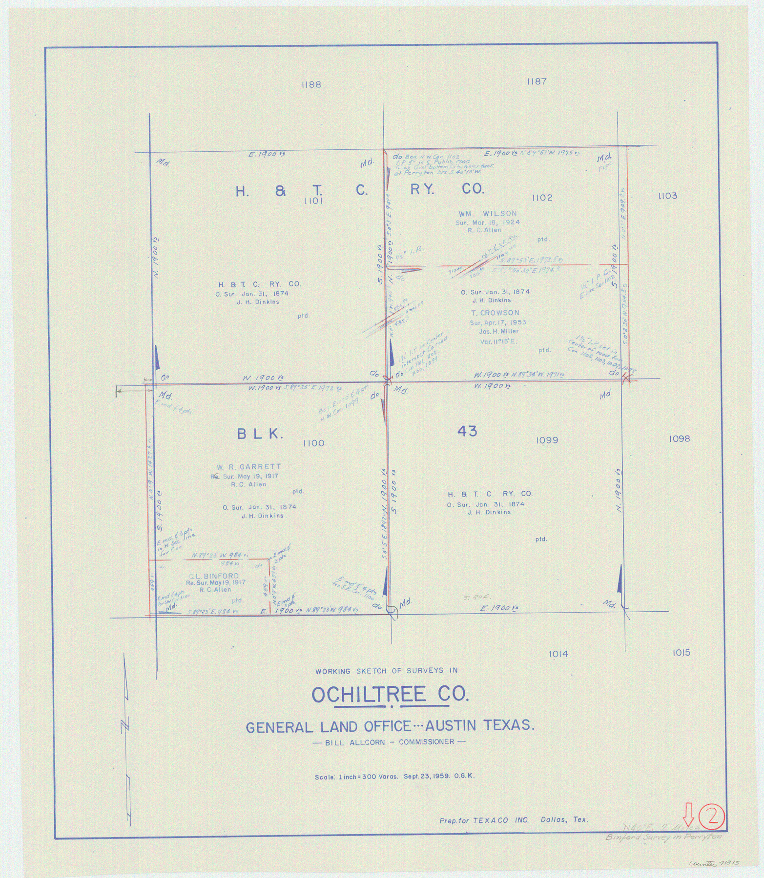
Ochiltree County Working Sketch 2
-
Map/Doc
71315
-
Collection
General Map Collection
-
Object Dates
9/23/1959 (Creation Date)
-
People and Organizations
Otto G. Kurio (Draftsman)
-
Counties
Ochiltree
-
Subjects
Surveying Working Sketch
-
Height x Width
23.9 x 20.8 inches
60.7 x 52.8 cm
-
Scale
1" = 300 varas
Part of: General Map Collection
Brewster County Working Sketch 83

Print $20.00
- Digital $50.00
Brewster County Working Sketch 83
1973
Size 43.6 x 41.1 inches
Map/Doc 67683
Starr County Sketch File 48a

Print $40.00
- Digital $50.00
Starr County Sketch File 48a
1950
Size 9.0 x 22.0 inches
Map/Doc 37005
Sketch of coast of Texas, Laguna Madre from Pt. of Rocks to Corpus Christi [and accompanying letter]
![72962, Sketch of coast of Texas, Laguna Madre from Pt. of Rocks to Corpus Christi [and accompanying letter], General Map Collection](https://historictexasmaps.com/wmedia_w700/maps/72962.tif.jpg)
Print $20.00
- Digital $50.00
Sketch of coast of Texas, Laguna Madre from Pt. of Rocks to Corpus Christi [and accompanying letter]
1881
Size 26.5 x 18.3 inches
Map/Doc 72962
Hays County Working Sketch 1

Print $20.00
- Digital $50.00
Hays County Working Sketch 1
1915
Size 20.0 x 17.3 inches
Map/Doc 66075
Webb County Boundary File 3a

Print $10.00
- Digital $50.00
Webb County Boundary File 3a
Size 14.2 x 8.7 inches
Map/Doc 59753
Jefferson County Rolled Sketch 50

Print $20.00
- Digital $50.00
Jefferson County Rolled Sketch 50
Size 34.2 x 41.6 inches
Map/Doc 9306
Val Verde County Sketch File 19

Print $4.00
- Digital $50.00
Val Verde County Sketch File 19
1858
Size 13.0 x 8.1 inches
Map/Doc 39229
Burleson County Working Sketch 29

Print $20.00
- Digital $50.00
Burleson County Working Sketch 29
1981
Size 24.7 x 24.7 inches
Map/Doc 67748
Glasscock County Rolled Sketch 4

Print $20.00
- Digital $50.00
Glasscock County Rolled Sketch 4
1928
Size 26.7 x 20.9 inches
Map/Doc 6015
Railroad and County Map of Texas

Print $20.00
- Digital $50.00
Railroad and County Map of Texas
1926
Size 42.9 x 45.2 inches
Map/Doc 65799
General Chart of the Coast No. XXI Gulf Coast from Galveston to the Rio Grande

Print $20.00
- Digital $50.00
General Chart of the Coast No. XXI Gulf Coast from Galveston to the Rio Grande
1883
Size 26.7 x 18.2 inches
Map/Doc 72727
Flight Mission No. DAG-18K, Frame 69, Matagorda County

Print $20.00
- Digital $50.00
Flight Mission No. DAG-18K, Frame 69, Matagorda County
1952
Size 16.3 x 16.2 inches
Map/Doc 86362
You may also like
Robertson County Working Sketch 10

Print $20.00
- Digital $50.00
Robertson County Working Sketch 10
1984
Size 20.1 x 21.6 inches
Map/Doc 63583
Sutton County Rolled Sketch 58

Print $20.00
- Digital $50.00
Sutton County Rolled Sketch 58
Size 31.2 x 15.9 inches
Map/Doc 7896
Right of Way and Track Map of The Missouri, Kansas & Texas Railway of Texas

Print $40.00
- Digital $50.00
Right of Way and Track Map of The Missouri, Kansas & Texas Railway of Texas
1918
Size 25.9 x 108.3 inches
Map/Doc 64526
Map of Jasper County

Print $40.00
- Digital $50.00
Map of Jasper County
1898
Size 49.1 x 39.6 inches
Map/Doc 66879
Flight Mission No. DQO-2K, Frame 86, Galveston County

Print $20.00
- Digital $50.00
Flight Mission No. DQO-2K, Frame 86, Galveston County
1952
Size 19.0 x 22.5 inches
Map/Doc 85013
Map of Public Land on Mustang Island

Print $20.00
- Digital $50.00
Map of Public Land on Mustang Island
1907
Size 17.7 x 22.3 inches
Map/Doc 91492
Colorado County Sketch File 30

Print $14.00
- Digital $50.00
Colorado County Sketch File 30
1943
Size 14.1 x 8.6 inches
Map/Doc 18977
Flight Mission No. DCL-7C, Frame 12, Kenedy County

Print $20.00
- Digital $50.00
Flight Mission No. DCL-7C, Frame 12, Kenedy County
1943
Size 15.4 x 15.3 inches
Map/Doc 86004
Gray County Sketch File 8

Print $20.00
- Digital $50.00
Gray County Sketch File 8
1888
Size 17.7 x 20.7 inches
Map/Doc 11577
Map of Bexar County

Print $20.00
- Digital $50.00
Map of Bexar County
1879
Size 24.2 x 27.6 inches
Map/Doc 4508
Palo Pinto County, Texas

Print $20.00
- Digital $50.00
Palo Pinto County, Texas
1879
Size 17.8 x 19.0 inches
Map/Doc 529
Shelby County Working Sketch 24

Print $20.00
- Digital $50.00
Shelby County Working Sketch 24
1985
Size 38.3 x 39.0 inches
Map/Doc 63878