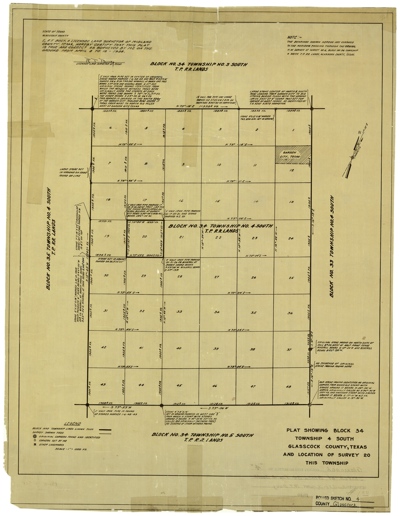
Glasscock County Rolled Sketch 4
Plat showing Block 34, Township 4 South, Glasscock County, Texas and location of survey 20 this Township
-
Map/Doc
6015
-
Collection
General Map Collection
-
Object Dates
4/18/1928 (Creation Date)
-
People and Organizations
R.T. Bucy (Surveyor/Engineer)
-
Counties
Glasscock
-
Subjects
Surveying Rolled Sketch
-
Height x Width
26.7 x 20.9 inches
67.8 x 53.1 cm
-
Medium
van dyke/brownline/sepia
-
Scale
1" = 1000 varas
Part of: General Map Collection
Index sheet to accompany map of survey for connecting the inland waters along margin of the Gulf of Mexico from Donaldsonville in Louisiana to the Rio Grande River in Texas

Print $20.00
- Digital $50.00
Index sheet to accompany map of survey for connecting the inland waters along margin of the Gulf of Mexico from Donaldsonville in Louisiana to the Rio Grande River in Texas
Size 18.2 x 27.4 inches
Map/Doc 72690

Upton County Sketch File 1

Print $40.00
- Digital $50.00
Upton County Sketch File 1
1881
Size 24.1 x 65.4 inches
Map/Doc 10412
Gray County Sketch File 1

Print $4.00
- Digital $50.00
Gray County Sketch File 1
1882
Size 10.4 x 7.2 inches
Map/Doc 24396
Map of the Straits of Florida and Gulf of Mexico

Print $20.00
- Digital $50.00
Map of the Straits of Florida and Gulf of Mexico
1851
Size 18.3 x 27.5 inches
Map/Doc 72673
Tyler County Boundary File 1

Print $2.00
- Digital $50.00
Tyler County Boundary File 1
Size 14.2 x 8.8 inches
Map/Doc 59494
Hays County Sketch File 1

Print $2.00
- Digital $50.00
Hays County Sketch File 1
1856
Size 12.6 x 8.3 inches
Map/Doc 26199
Map of Erath County

Print $40.00
- Digital $50.00
Map of Erath County
1896
Size 49.6 x 43.5 inches
Map/Doc 4943
Bell County Working Sketch 7

Print $20.00
- Digital $50.00
Bell County Working Sketch 7
1947
Size 43.7 x 34.9 inches
Map/Doc 67347
Bandera County Sketch File 34

Print $6.00
- Digital $50.00
Bandera County Sketch File 34
1987
Size 14.1 x 8.7 inches
Map/Doc 14030
Lynn County Sketch File 18

Print $4.00
- Digital $50.00
Lynn County Sketch File 18
1940
Size 11.2 x 8.8 inches
Map/Doc 30514
Schleicher County Sketch File 41

Print $6.00
- Digital $50.00
Schleicher County Sketch File 41
1963
Size 16.2 x 9.9 inches
Map/Doc 36544
You may also like
Brewster County Rolled Sketch 127

Print $20.00
- Digital $50.00
Brewster County Rolled Sketch 127
1969
Size 39.0 x 43.8 inches
Map/Doc 8521
Copy of Surveyor's Field Book, Morris Browning - In Blocks 7, 5 & 4, I&GNRRCo., Hutchinson and Carson Counties, Texas

Print $2.00
- Digital $50.00
Copy of Surveyor's Field Book, Morris Browning - In Blocks 7, 5 & 4, I&GNRRCo., Hutchinson and Carson Counties, Texas
1888
Size 6.9 x 8.8 inches
Map/Doc 62275
Flight Mission No. CRC-3R, Frame 24, Chambers County

Print $20.00
- Digital $50.00
Flight Mission No. CRC-3R, Frame 24, Chambers County
1956
Size 18.6 x 22.2 inches
Map/Doc 84798
Galveston County NRC Article 33.136 Sketch 5

Print $20.00
- Digital $50.00
Galveston County NRC Article 33.136 Sketch 5
2001
Size 23.5 x 19.1 inches
Map/Doc 61587
Atascosa County Boundary File 5

Print $32.00
- Digital $50.00
Atascosa County Boundary File 5
Size 8.8 x 6.3 inches
Map/Doc 50198
Nacogdoches County Working Sketch 11

Print $20.00
- Digital $50.00
Nacogdoches County Working Sketch 11
1985
Size 41.1 x 28.0 inches
Map/Doc 71227
Cameron County

Print $20.00
- Digital $50.00
Cameron County
1913
Size 30.0 x 33.8 inches
Map/Doc 1793
Webb County Sketch File 10-2

Print $10.00
- Digital $50.00
Webb County Sketch File 10-2
1933
Size 16.9 x 10.9 inches
Map/Doc 39766
Webb County Rolled Sketch 22

Print $40.00
- Digital $50.00
Webb County Rolled Sketch 22
Size 108.0 x 43.7 inches
Map/Doc 10120
Bandera County Boundary File 4a

Print $32.00
- Digital $50.00
Bandera County Boundary File 4a
Size 13.3 x 8.7 inches
Map/Doc 50276

Medina County Sketch File 5

Print $8.00
- Digital $50.00
Medina County Sketch File 5
Size 8.2 x 3.8 inches
Map/Doc 31450