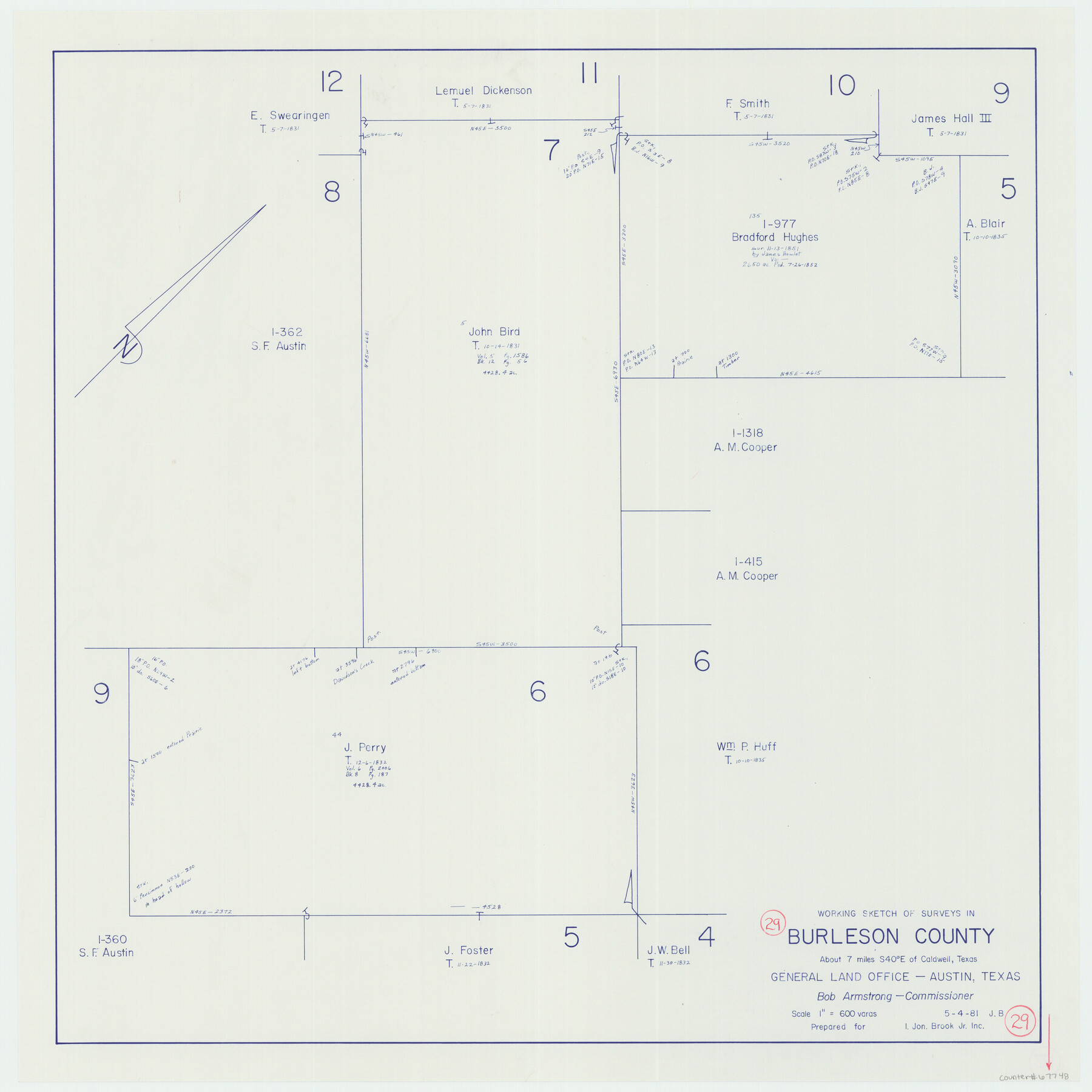
Burleson County Working Sketch 29
-
Map/Doc
67748
-
Collection
General Map Collection
-
Object Dates
5/4/1981 (Creation Date)
-
Counties
Burleson
-
Subjects
Surveying Working Sketch
-
Height x Width
24.7 x 24.7 inches
62.7 x 62.7 cm
-
Scale
1" = 600 varas
Part of: General Map Collection
Webb County Rolled Sketch 66

Print $20.00
- Digital $50.00
Webb County Rolled Sketch 66
1957
Size 31.9 x 21.8 inches
Map/Doc 8215
Cottle County Working Sketch 24

Print $20.00
- Digital $50.00
Cottle County Working Sketch 24
2014
Size 10.6 x 18.3 inches
Map/Doc 93707
[Texas & Pacific Railway, Longview to Dallas]
![64098, [Texas & Pacific Railway, Longview to Dallas], General Map Collection](https://historictexasmaps.com/wmedia_w700/maps/64098.tif.jpg)
Print $40.00
- Digital $50.00
[Texas & Pacific Railway, Longview to Dallas]
1873
Size 14.5 x 121.6 inches
Map/Doc 64098
Liberty County Rolled Sketch P

Print $33.00
- Digital $50.00
Liberty County Rolled Sketch P
Size 10.3 x 16.5 inches
Map/Doc 46545
Runnels County Rolled Sketch 46

Print $20.00
- Digital $50.00
Runnels County Rolled Sketch 46
1954
Size 32.3 x 38.5 inches
Map/Doc 10622
Map of Baffin & Alazan Bays, Cayo Infiernillo in Kenedy & Kleberg Counties Showing Subdivision for Mineral Development

Print $20.00
- Digital $50.00
Map of Baffin & Alazan Bays, Cayo Infiernillo in Kenedy & Kleberg Counties Showing Subdivision for Mineral Development
1937
Size 42.4 x 40.4 inches
Map/Doc 3016
University Lands Blocks 29-33, Crockett County, Texas

Print $20.00
- Digital $50.00
University Lands Blocks 29-33, Crockett County, Texas
1936
Size 29.8 x 42.7 inches
Map/Doc 2443
Crockett County Rolled Sketch 16

Print $20.00
- Digital $50.00
Crockett County Rolled Sketch 16
1880
Size 36.2 x 26.2 inches
Map/Doc 5581
Hansford County Working Sketch 5

Print $20.00
- Digital $50.00
Hansford County Working Sketch 5
1967
Size 30.2 x 28.3 inches
Map/Doc 63377
Liberty County Working Sketch 34

Print $20.00
- Digital $50.00
Liberty County Working Sketch 34
1946
Size 26.7 x 21.2 inches
Map/Doc 70493
Flight Mission No. CGI-3N, Frame 79, Cameron County

Print $20.00
- Digital $50.00
Flight Mission No. CGI-3N, Frame 79, Cameron County
1954
Size 18.6 x 22.4 inches
Map/Doc 84573
Taylor County

Print $20.00
- Digital $50.00
Taylor County
1934
Size 42.0 x 36.6 inches
Map/Doc 77432
You may also like
Dickens County Sketch File 19a

Print $23.00
- Digital $50.00
Dickens County Sketch File 19a
Size 9.6 x 7.8 inches
Map/Doc 21031
Flight Mission No. CRE-1R, Frame 132, Jackson County

Print $20.00
- Digital $50.00
Flight Mission No. CRE-1R, Frame 132, Jackson County
1956
Size 16.2 x 16.0 inches
Map/Doc 85340
Map of the City of Galveston Situated on the East end of Galveston Island

Print $20.00
- Digital $50.00
Map of the City of Galveston Situated on the East end of Galveston Island
1838
Size 22.0 x 38.1 inches
Map/Doc 2170
Karte von Texas entworfen nach den Vermessungen welche in den Acten der General-Land-Office der Republick

Print $20.00
- Digital $50.00
Karte von Texas entworfen nach den Vermessungen welche in den Acten der General-Land-Office der Republick
1846
Size 16.9 x 17.6 inches
Map/Doc 94118
Map of Survey of that portion of Fort Crockett, County of Galveston, Texas, lying east of 53rd Street & West of 39th Street, City of Galveston

Print $40.00
- Digital $50.00
Map of Survey of that portion of Fort Crockett, County of Galveston, Texas, lying east of 53rd Street & West of 39th Street, City of Galveston
1957
Size 23.0 x 59.8 inches
Map/Doc 73618
Frio County Rolled Sketch 23

Print $20.00
- Digital $50.00
Frio County Rolled Sketch 23
1962
Size 39.4 x 40.8 inches
Map/Doc 8912
Harris County Working Sketch 26

Print $20.00
- Digital $50.00
Harris County Working Sketch 26
1930
Size 23.9 x 27.2 inches
Map/Doc 65918
General Highway Map, Frio County, Texas

Print $20.00
General Highway Map, Frio County, Texas
1940
Size 18.4 x 24.9 inches
Map/Doc 79095
[H. & G. N. RR. Co. Block 1]
![90888, [H. & G. N. RR. Co. Block 1], Twichell Survey Records](https://historictexasmaps.com/wmedia_w700/maps/90888-1.tif.jpg)
Print $20.00
- Digital $50.00
[H. & G. N. RR. Co. Block 1]
Size 37.1 x 43.6 inches
Map/Doc 90888
Runnels County Rolled Sketch 51

Print $20.00
- Digital $50.00
Runnels County Rolled Sketch 51
Size 26.1 x 34.3 inches
Map/Doc 7536
Brooks County Working Sketch 20

Print $20.00
- Digital $50.00
Brooks County Working Sketch 20
Size 16.5 x 21.6 inches
Map/Doc 78198
Andrews County Working Sketch 19

Print $20.00
- Digital $50.00
Andrews County Working Sketch 19
1964
Size 24.9 x 23.5 inches
Map/Doc 67065