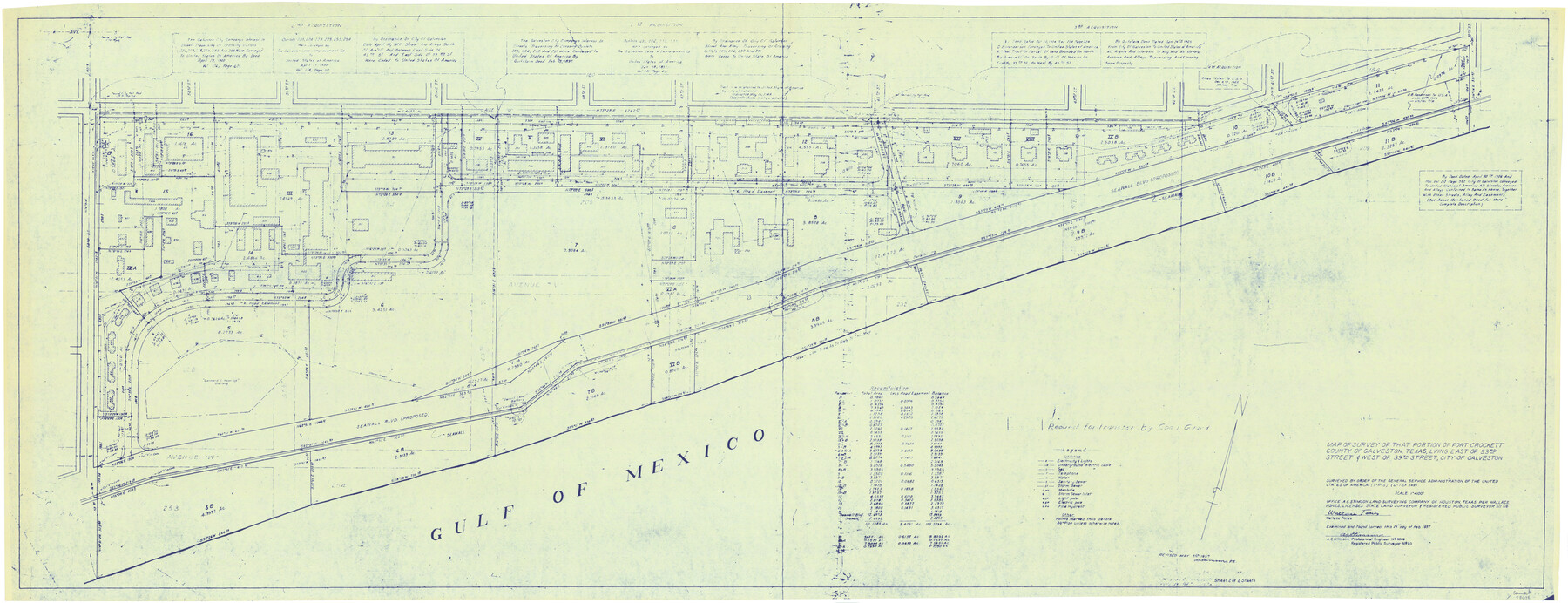
Map of Survey of that portion of Fort Crockett, County of Galveston, Texas, lying east of 53rd Street & West of 39th Street, City of Galveston
Galveston Miscellaneous 8
-
Map/Doc
73618
-
Collection
General Map Collection
-
Object Dates
5/8/1957 (Creation Date)
-
People and Organizations
A. C. Stimson Land Surveying Company of Houston (Publisher)
A.C. Stimson (Surveyor/Engineer)
-
Counties
Galveston
-
Subjects
City
-
Height x Width
23.0 x 59.8 inches
58.4 x 151.9 cm
Part of: General Map Collection
Duval County Sketch File 71

Print $4.00
- Digital $50.00
Duval County Sketch File 71
1953
Size 15.2 x 9.0 inches
Map/Doc 21458
Harris County Sketch File 80a

Print $20.00
- Digital $50.00
Harris County Sketch File 80a
1892
Size 27.8 x 17.6 inches
Map/Doc 11667
Flight Mission No. CGI-4N, Frame 161, Cameron County

Print $20.00
- Digital $50.00
Flight Mission No. CGI-4N, Frame 161, Cameron County
1955
Size 18.7 x 22.4 inches
Map/Doc 84669
Flight Mission No. DIX-6P, Frame 110, Aransas County

Print $20.00
- Digital $50.00
Flight Mission No. DIX-6P, Frame 110, Aransas County
1956
Size 19.7 x 23.4 inches
Map/Doc 83816
Calhoun County Rolled Sketch 30

Print $20.00
- Digital $50.00
Calhoun County Rolled Sketch 30
1974
Size 18.5 x 27.5 inches
Map/Doc 5496
Stephens County Working Sketch 3

Print $3.00
- Digital $50.00
Stephens County Working Sketch 3
1919
Size 11.3 x 9.9 inches
Map/Doc 63946
Red River County Working Sketch 61

Print $20.00
- Digital $50.00
Red River County Working Sketch 61
1973
Size 37.8 x 38.5 inches
Map/Doc 72044
Jack County Sketch File 18c

Print $60.00
- Digital $50.00
Jack County Sketch File 18c
Size 20.0 x 30.7 inches
Map/Doc 11828
South Part of Brewster Co.

Print $40.00
- Digital $50.00
South Part of Brewster Co.
1955
Size 48.2 x 40.5 inches
Map/Doc 73089
Flight Mission No. DQN-1K, Frame 117, Calhoun County

Print $20.00
- Digital $50.00
Flight Mission No. DQN-1K, Frame 117, Calhoun County
1953
Size 18.5 x 22.2 inches
Map/Doc 84183
Travis County Sketch File 63

Print $14.00
- Digital $50.00
Travis County Sketch File 63
Size 13.5 x 9.2 inches
Map/Doc 38431
Flight Mission No. DCL-6C, Frame 122, Kenedy County

Print $20.00
- Digital $50.00
Flight Mission No. DCL-6C, Frame 122, Kenedy County
1943
Size 18.5 x 22.4 inches
Map/Doc 85952
You may also like
Irion County Sketch File 13

Print $4.00
- Digital $50.00
Irion County Sketch File 13
1940
Size 11.2 x 8.8 inches
Map/Doc 27484
Map of Nacogdoches County

Print $40.00
- Digital $50.00
Map of Nacogdoches County
1839
Size 81.0 x 40.9 inches
Map/Doc 93374
Presidio County Sketch File 28

Print $20.00
- Digital $50.00
Presidio County Sketch File 28
1890
Size 30.2 x 16.1 inches
Map/Doc 11709
[League 239, Portion of Block B5]
![91443, [League 239, Portion of Block B5], Twichell Survey Records](https://historictexasmaps.com/wmedia_w700/maps/91443-1.tif.jpg)
Print $20.00
- Digital $50.00
[League 239, Portion of Block B5]
Size 18.4 x 11.7 inches
Map/Doc 91443

Hutchinson County Working Sketch 5

Print $20.00
- Digital $50.00
Hutchinson County Working Sketch 5
1912
Size 16.0 x 11.4 inches
Map/Doc 66363
Well Locations in Gaines County, Texas for American Liberty Oil Co.

Print $20.00
- Digital $50.00
Well Locations in Gaines County, Texas for American Liberty Oil Co.
Size 20.1 x 22.2 inches
Map/Doc 92855
Map of the United States constructed from the latest authorities

Print $20.00
- Digital $50.00
Map of the United States constructed from the latest authorities
1825
Size 19.4 x 24.5 inches
Map/Doc 93924
Dickens County Sketch File 18a

Print $20.00
- Digital $50.00
Dickens County Sketch File 18a
Size 17.6 x 19.4 inches
Map/Doc 11322
Bastrop County Rolled Sketch 1A

Print $20.00
- Digital $50.00
Bastrop County Rolled Sketch 1A
Size 37.0 x 24.5 inches
Map/Doc 5122
Hardeman County Sketch File 3

Print $8.00
- Digital $50.00
Hardeman County Sketch File 3
1880
Size 14.2 x 8.8 inches
Map/Doc 24987
Flight Mission No. BQR-22K, Frame 41, Brazoria County

Print $20.00
- Digital $50.00
Flight Mission No. BQR-22K, Frame 41, Brazoria County
1953
Size 18.8 x 22.5 inches
Map/Doc 84125