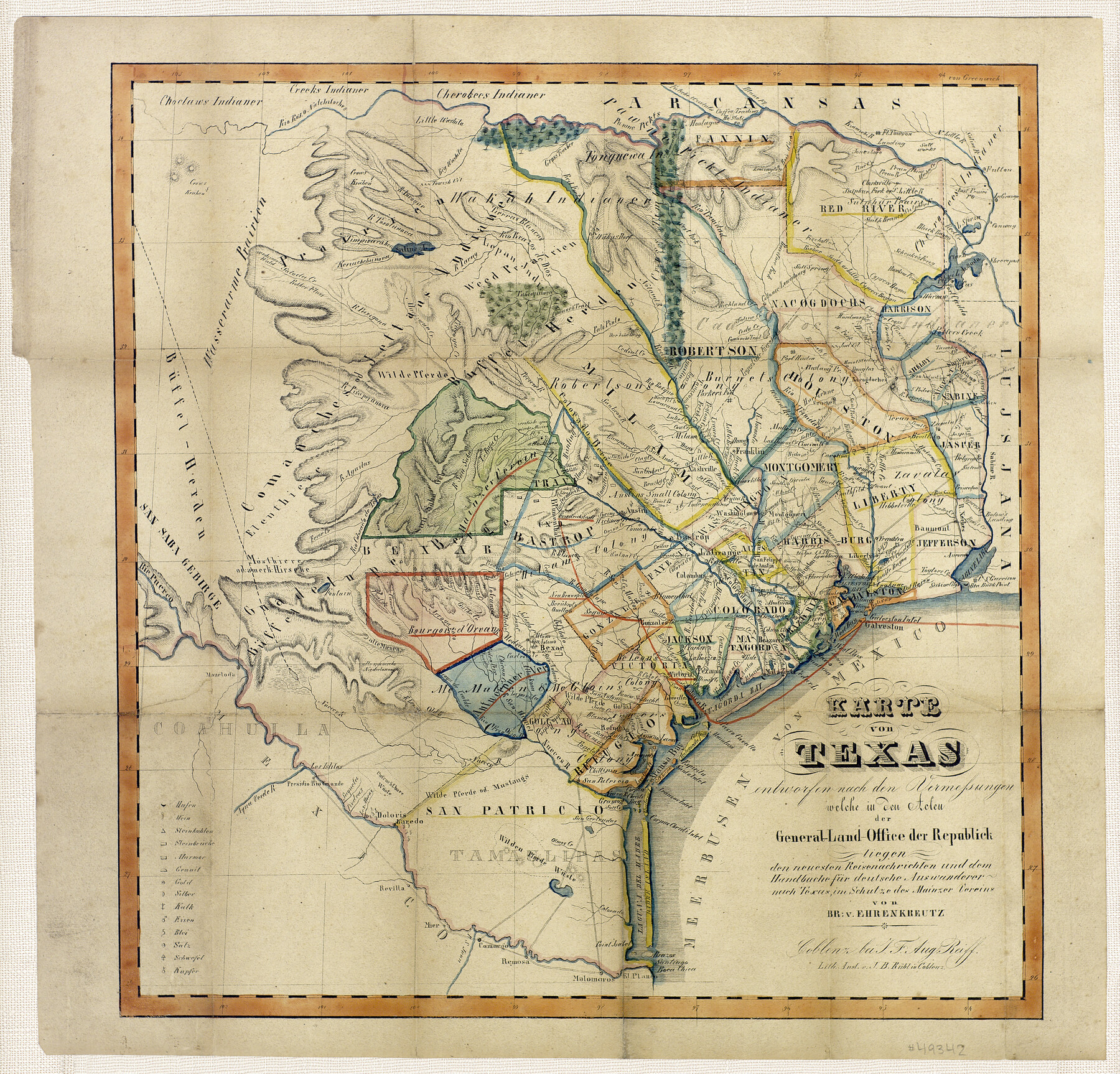
Karte von Texas entworfen nach den Vermessungen welche in den Acten der General-Land-Office der Republick
-
Map/Doc
94118
-
Collection
Holcomb Map Collection
-
Object Dates
1846 (Creation Date)
-
People and Organizations
Baron von Ehrenkreutz (Cartographer)
-
Subjects
Republic of Texas
-
Height x Width
16.9 x 17.6 inches
42.9 x 44.7 cm
-
Comments
Courtesy of Frank and Carol Holcomb.
Map accompanied a German emigrant guide to Texas. To view this guide, click "Download PDF" link above.
Part of: Holcomb Map Collection
The State of Texas

Print $20.00
- Digital $50.00
The State of Texas
1845
Size 18.9 x 23.2 inches
Map/Doc 93870
Mapa de los Estados Unidos de Méjico, Segun lo organizado y definido por las varias actas del Congreso de dicha Republica: y construido por las mejores autoridades

Print $20.00
- Digital $50.00
Mapa de los Estados Unidos de Méjico, Segun lo organizado y definido por las varias actas del Congreso de dicha Republica: y construido por las mejores autoridades
1847
Size 31.3 x 42.3 inches
Map/Doc 93878

Karte von Texas entworfen nach den Vermessungen welche in den Acten der General-Land-Office der Republick

Print $20.00
- Digital $50.00
Karte von Texas entworfen nach den Vermessungen welche in den Acten der General-Land-Office der Republick
1846
Size 16.9 x 17.6 inches
Map/Doc 94118
Map of the State of Texas from the Latest Authorities

Print $2.00
- Digital $50.00
Map of the State of Texas from the Latest Authorities
1854
Size 5.2 x 3.5 inches
Map/Doc 93902
Nova et Acurata Totius Americae Tabula

Print $40.00
Nova et Acurata Totius Americae Tabula
1608
Size 40.8 x 56.5 inches
Map/Doc 97019
Map of Mexico, including Yucatan & Upper California, exhibiting the chief cities and towns, the principal travelling routes &c.

Print $20.00
- Digital $50.00
Map of Mexico, including Yucatan & Upper California, exhibiting the chief cities and towns, the principal travelling routes &c.
1846
Size 18.3 x 26.1 inches
Map/Doc 93871

Map of Michigan and Wisconsin designed to accompany Smith's Geography for Schools

Print $20.00
- Digital $50.00
Map of Michigan and Wisconsin designed to accompany Smith's Geography for Schools
1850
Size 9.7 x 12.1 inches
Map/Doc 93890
Map of the United States of America, the British Provinces, Mexico, the West Indies and Central America with part of New Granada and Venezuela

Print $20.00
- Digital $50.00
Map of the United States of America, the British Provinces, Mexico, the West Indies and Central America with part of New Granada and Venezuela
1855
Size 34.7 x 44.0 inches
Map/Doc 93904
Texas compiled from the latest and best authorities

Print $20.00
- Digital $50.00
Texas compiled from the latest and best authorities
1842
Size 11.8 x 14.0 inches
Map/Doc 93864
J. De Cordova's Map of the State of Texas Compiled from the records of the General Land Office of the State

Print $2.00
- Digital $50.00
J. De Cordova's Map of the State of Texas Compiled from the records of the General Land Office of the State
1855
Size 6.8 x 4.0 inches
Map/Doc 93912
You may also like
Map of Trinity Co.

Print $20.00
- Digital $50.00
Map of Trinity Co.
1896
Size 41.3 x 38.3 inches
Map/Doc 78446
A plat representing the survey and resubdivision of four tracts of land known as tracts no. 27, no. 26, no. 23, and no. 22, all of which are part of the Tara Subdivision, an unrecorded subdivision of 263.28 acres out of the J. M. Speer Subdivision

Print $6.00
- Digital $50.00
A plat representing the survey and resubdivision of four tracts of land known as tracts no. 27, no. 26, no. 23, and no. 22, all of which are part of the Tara Subdivision, an unrecorded subdivision of 263.28 acres out of the J. M. Speer Subdivision
1991
Size 24.7 x 34.3 inches
Map/Doc 3112
Hemphill County Working Sketch 32

Print $20.00
- Digital $50.00
Hemphill County Working Sketch 32
1976
Size 45.8 x 34.2 inches
Map/Doc 66127
Robertson County Working Sketch 8

Print $20.00
- Digital $50.00
Robertson County Working Sketch 8
1983
Size 36.7 x 38.7 inches
Map/Doc 63581
[Block D, John H. Gibson]
![92003, [Block D, John H. Gibson], Twichell Survey Records](https://historictexasmaps.com/wmedia_w700/maps/92003-1.tif.jpg)
Print $20.00
- Digital $50.00
[Block D, John H. Gibson]
Size 33.2 x 18.4 inches
Map/Doc 92003
Potter County Sketch File 1

Print $28.00
- Digital $50.00
Potter County Sketch File 1
1882
Size 7.4 x 8.8 inches
Map/Doc 34378

Upton County Rolled Sketch 58

Print $20.00
- Digital $50.00
Upton County Rolled Sketch 58
1988
Size 38.6 x 36.2 inches
Map/Doc 10061
[Sketch for Mineral Application 26501 - Sabine River, T. A. Oldhausen]
![2847, [Sketch for Mineral Application 26501 - Sabine River, T. A. Oldhausen], General Map Collection](https://historictexasmaps.com/wmedia_w700/maps/2847.tif.jpg)
Print $20.00
- Digital $50.00
[Sketch for Mineral Application 26501 - Sabine River, T. A. Oldhausen]
1931
Size 24.7 x 37.1 inches
Map/Doc 2847
Palo Pinto County Working Sketch 14

Print $20.00
- Digital $50.00
Palo Pinto County Working Sketch 14
1960
Size 27.2 x 27.4 inches
Map/Doc 71397
Trinity County Sketch File 8

Print $6.00
- Digital $50.00
Trinity County Sketch File 8
1859
Size 12.8 x 7.9 inches
Map/Doc 38513
Wilson County Sketch File 12

Print $8.00
- Digital $50.00
Wilson County Sketch File 12
1841
Size 14.1 x 8.6 inches
Map/Doc 40425