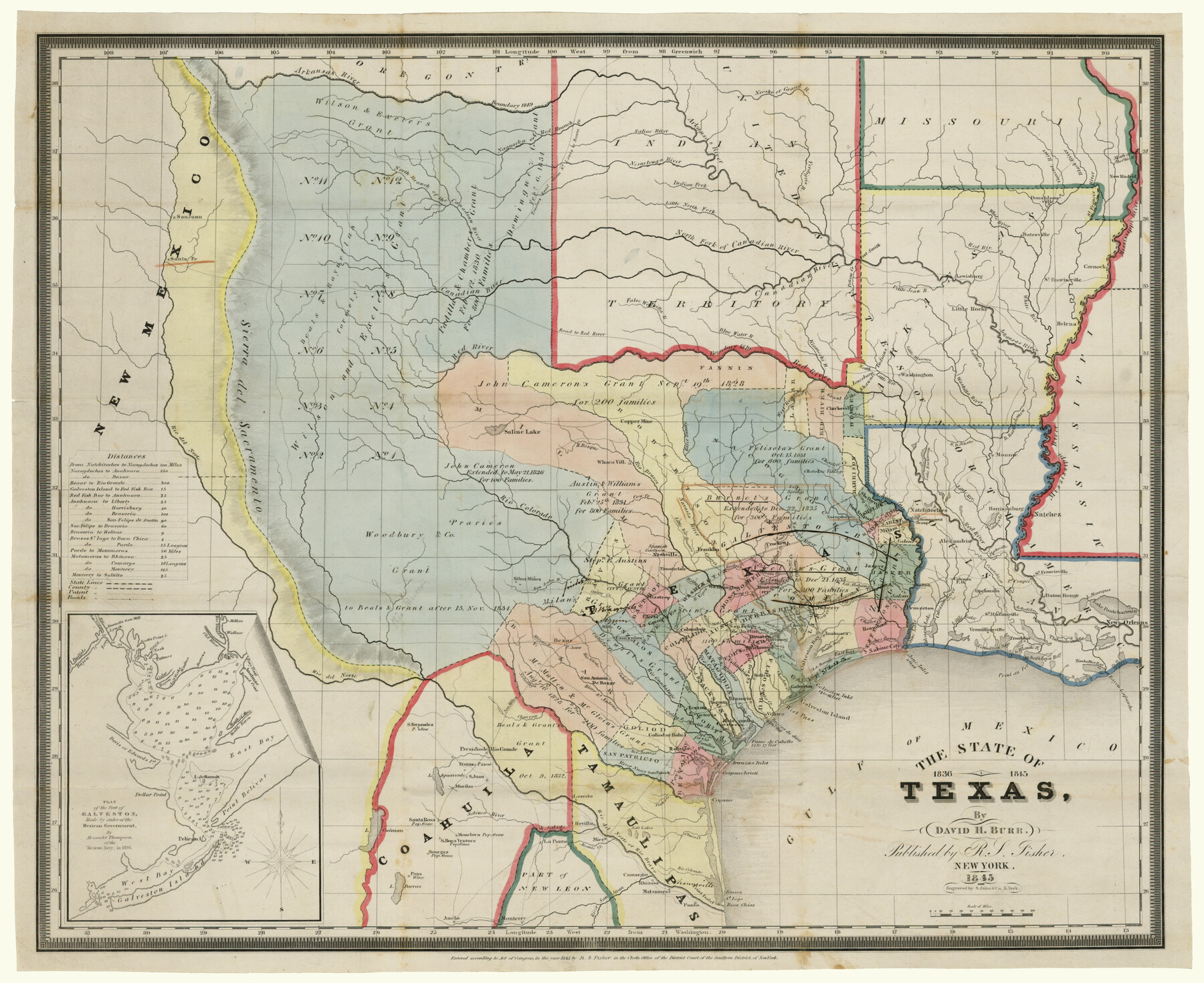
The State of Texas
[Inset:] Plan of the Port of Galveston made by order of the Mexican Government
-
Map/Doc
93870
-
Collection
Holcomb Map Collection
-
Object Dates
1845 (Creation Date)
-
People and Organizations
R. S. Fisher (Publisher)
S. Stiles & Co. (Printer)
David H. Burr (Author)
-
Subjects
State of Texas
-
Height x Width
18.9 x 23.2 inches
48.0 x 58.9 cm
-
Comments
Courtesy of Frank and Carol Holcomb.
For land documents and correspondence that originally accompanied this map click the "Download PDF" link above. -
URLs
https://medium.com/save-texas-history/the-state-of-texas-1845-e6a5bd239910#.hpxv42t2u
Part of: Holcomb Map Collection
Map of Oceanica designed to accompany Smith's Geography for Schools

Print $20.00
- Digital $50.00
Map of Oceanica designed to accompany Smith's Geography for Schools
1850
Size 9.7 x 12.1 inches
Map/Doc 93898
Reynolds's Political Map of the United States Designed to Exhibit the Comparative Area of the Free and Slave States and the Territory open to Slavery or Freedom by the Repeal of the Missouri Compromise

Print $20.00
- Digital $50.00
Reynolds's Political Map of the United States Designed to Exhibit the Comparative Area of the Free and Slave States and the Territory open to Slavery or Freedom by the Repeal of the Missouri Compromise
1856
Size 24.0 x 27.0 inches
Map/Doc 97115
A General Map of North America; In which is Express'd the several New Roads, Forts, Engagements, & c. taken from Actual Surveys and Observations Made in the Army employ'd there

Print $20.00
- Digital $50.00
A General Map of North America; In which is Express'd the several New Roads, Forts, Engagements, & c. taken from Actual Surveys and Observations Made in the Army employ'd there
1761
Size 37.6 x 38.6 inches
Map/Doc 93827
Map of the State of Coahuila and Texas

Print $20.00
- Digital $50.00
Map of the State of Coahuila and Texas
1834
Size 13.2 x 14.7 inches
Map/Doc 93848
North America corrected from the observations communicated to the Royal Society at London and the Royal Academy at Paris

Print $20.00
- Digital $50.00
North America corrected from the observations communicated to the Royal Society at London and the Royal Academy at Paris
1710
Size 38.9 x 26.9 inches
Map/Doc 93820
Map of Texas to accompany "Brady's Glimpses of Texas"

Print $20.00
- Digital $50.00
Map of Texas to accompany "Brady's Glimpses of Texas"
1871
Size 13.0 x 16.1 inches
Map/Doc 93907
A Map of North America, constructed according to the latest information

Print $40.00
- Digital $50.00
A Map of North America, constructed according to the latest information
1822
Size 44.4 x 59.6 inches
Map/Doc 93845
Karte von Texas entworfen nach den Vermessungen welche in den Acten der General-Land-Office der Republick

Print $20.00
- Digital $50.00
Karte von Texas entworfen nach den Vermessungen welche in den Acten der General-Land-Office der Republick
1846
Size 16.9 x 17.6 inches
Map/Doc 94118
Map of Texas compiled from surveys at the Land Office of Texas

Print $20.00
- Digital $50.00
Map of Texas compiled from surveys at the Land Office of Texas
1851
Size 26.7 x 19.1 inches
Map/Doc 96431
Map of the Middle States designed to accompany Smith's Geography for Schools

Print $20.00
- Digital $50.00
Map of the Middle States designed to accompany Smith's Geography for Schools
1850
Size 19.4 x 12.2 inches
Map/Doc 93887
Amèrica noviter delineata

Print $20.00
- Digital $50.00
Amèrica noviter delineata
1630
Size 21.5 x 24.7 inches
Map/Doc 93814
A New Map of Texas with the Contiguous American & Mexican States

Print $20.00
- Digital $50.00
A New Map of Texas with the Contiguous American & Mexican States
1837
Size 12.5 x 15.1 inches
Map/Doc 96643
You may also like
Crockett County Working Sketch 12

Print $20.00
- Digital $50.00
Crockett County Working Sketch 12
1915
Size 19.3 x 15.4 inches
Map/Doc 68345
Kent County Rolled Sketch 8

Print $20.00
- Digital $50.00
Kent County Rolled Sketch 8
1873
Size 31.5 x 35.5 inches
Map/Doc 9344
Flight Mission No. DIX-8P, Frame 92, Aransas County

Print $20.00
- Digital $50.00
Flight Mission No. DIX-8P, Frame 92, Aransas County
1956
Size 18.5 x 22.3 inches
Map/Doc 83917
Webb County Sketch File 14a

Print $40.00
- Digital $50.00
Webb County Sketch File 14a
1893
Size 17.4 x 13.7 inches
Map/Doc 39810
Pecos County Working Sketch 2

Print $20.00
- Digital $50.00
Pecos County Working Sketch 2
Size 18.1 x 28.3 inches
Map/Doc 71472

Revised map of Matagorda Bay and vicinity in Matagorda and Calhoun Counties showing subdivision for mineral development

Print $40.00
- Digital $50.00
Revised map of Matagorda Bay and vicinity in Matagorda and Calhoun Counties showing subdivision for mineral development
1941
Size 43.4 x 56.6 inches
Map/Doc 3098
Gaines County Rolled Sketch 35

Print $20.00
- Digital $50.00
Gaines County Rolled Sketch 35
2014
Size 18.7 x 25.9 inches
Map/Doc 93695
In the Supreme Court of the United States The State of Oklahoma, Complainant vs. The State of Texas, Defendant, The United States of America, Intervener - 1921

Print $40.00
- Digital $50.00
In the Supreme Court of the United States The State of Oklahoma, Complainant vs. The State of Texas, Defendant, The United States of America, Intervener - 1921
1921
Size 25.7 x 61.1 inches
Map/Doc 75127

Old Miscellaneous File 9

Print $4.00
- Digital $50.00
Old Miscellaneous File 9
1871
Size 9.8 x 8.0 inches
Map/Doc 75433
Winkler County Working Sketch 2

Print $20.00
- Digital $50.00
Winkler County Working Sketch 2
1944
Size 36.9 x 29.9 inches
Map/Doc 72596