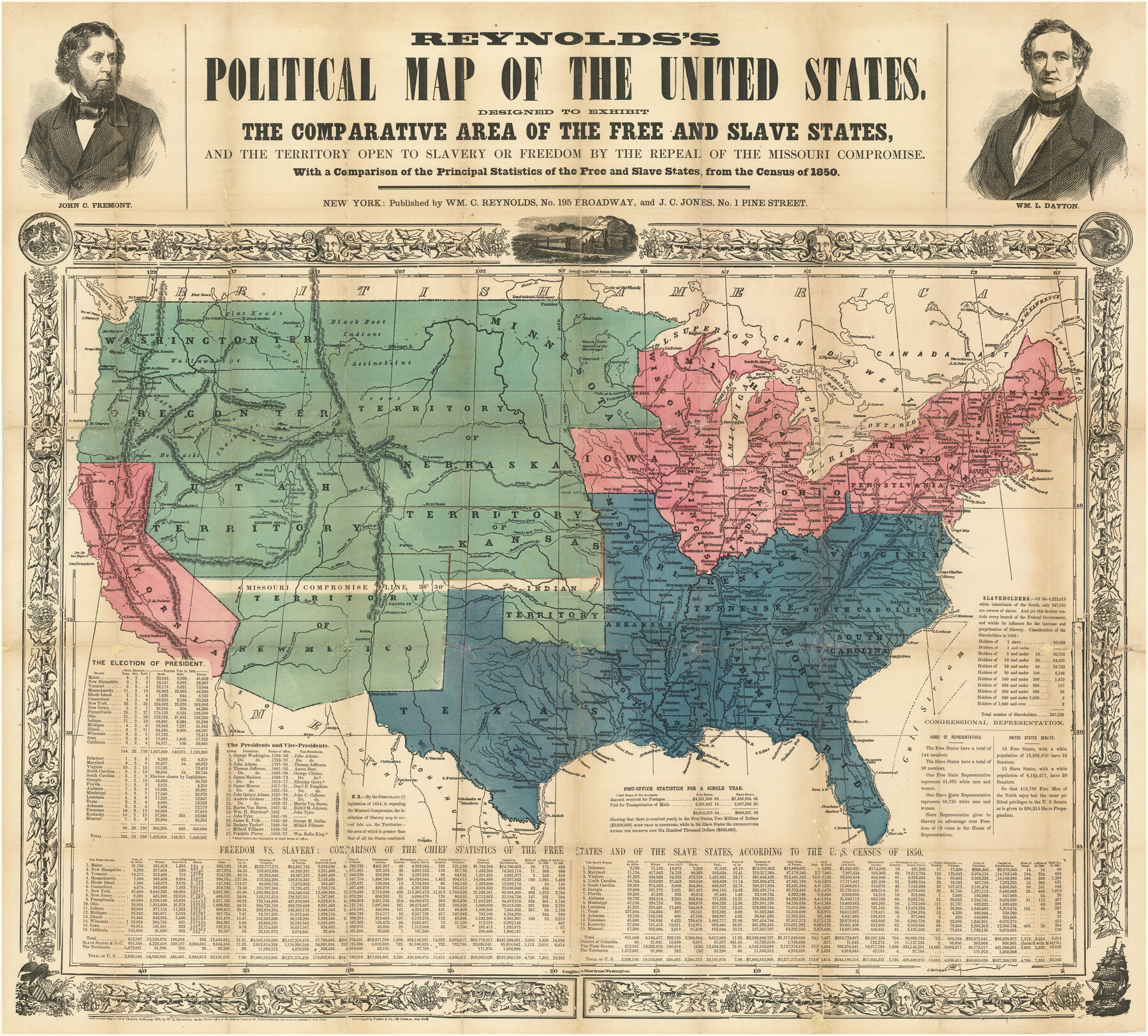
Reynolds's Political Map of the United States Designed to Exhibit the Comparative Area of the Free and Slave States and the Territory open to Slavery or Freedom by the Repeal of the Missouri Compromise
With a Comparison of the Principal Statistics of the Free and Slave States, from the Census of 1850
-
Map/Doc
97115
-
Collection
Holcomb Map Collection
-
Object Dates
1856 (Creation Date)
-
People and Organizations
William C. Reynolds (Publisher)
J.C. Jones (Publisher)
-
Subjects
United States
-
Height x Width
24.0 x 27.0 inches
61.0 x 68.6 cm
-
Comments
Courtesy of Frank and Carol Holcomb.
Part of: Holcomb Map Collection
Map of Texas compiled from surveys included in the General Land Office

Print $20.00
- Digital $50.00
Map of Texas compiled from surveys included in the General Land Office
1851
Size 31.4 x 25.3 inches
Map/Doc 94417
Map of Texas to accompany "Brady's Glimpses of Texas"

Print $20.00
- Digital $50.00
Map of Texas to accompany "Brady's Glimpses of Texas"
1871
Size 13.0 x 16.1 inches
Map/Doc 93907
General Topographical Map. Sheet XXII

Print $20.00
- Digital $50.00
General Topographical Map. Sheet XXII
1891
Size 18.4 x 29.4 inches
Map/Doc 97526
Carta Geografica General de la Republica Mexicana

Print $40.00
- Digital $50.00
Carta Geografica General de la Republica Mexicana
1845
Size 38.1 x 52.9 inches
Map/Doc 96438
Amèrica noviter delineata

Print $20.00
- Digital $50.00
Amèrica noviter delineata
1630
Size 21.5 x 24.7 inches
Map/Doc 93814
Map of the World on Mercator's Projection, flags of all nations and cities of the United States

Print $40.00
- Digital $50.00
Map of the World on Mercator's Projection, flags of all nations and cities of the United States
1874
Size 40.4 x 55.6 inches
Map/Doc 93914
L'Amerique, divisée selon l[']etendue de ses principales parties, et dont les points principaux sont placez sur les observations de messieurs de l'Academie Royale des Sciences
![95688, L'Amerique, divisée selon l[']etendue de ses principales parties, et dont les points principaux sont placez sur les observations de messieurs de l'Academie Royale des Sciences, Holcomb Digital Map Collection](https://historictexasmaps.com/wmedia_w700/maps/95688.tif.jpg)
Print $40.00
- Digital $50.00
L'Amerique, divisée selon l[']etendue de ses principales parties, et dont les points principaux sont placez sur les observations de messieurs de l'Academie Royale des Sciences
1705
Size 44.9 x 65.4 inches
Map/Doc 95688
Colton's New Map of the State of Texas, the Indian Territory and adjoining portions of New Mexico, Louisiana and Arkansas

Print $20.00
- Digital $50.00
Colton's New Map of the State of Texas, the Indian Territory and adjoining portions of New Mexico, Louisiana and Arkansas
1882
Size 32.8 x 37.3 inches
Map/Doc 93909
Pressler's Map of the State of Texas

Print $40.00
- Digital $50.00
Pressler's Map of the State of Texas
1862
Size 48.0 x 52.7 inches
Map/Doc 95714
America with those known parts in that unknowne worlde both people and manner of buildings

Print $20.00
- Digital $50.00
America with those known parts in that unknowne worlde both people and manner of buildings
1626
Size 17.2 x 22.3 inches
Map/Doc 93830
Reynolds's Political Map of the United States Designed to Exhibit the Comparative Area of the Free and Slave States and the Territory open to Slavery or Freedom by the Repeal of the Missouri Compromise

Print $20.00
- Digital $50.00
Reynolds's Political Map of the United States Designed to Exhibit the Comparative Area of the Free and Slave States and the Territory open to Slavery or Freedom by the Repeal of the Missouri Compromise
1856
Size 24.0 x 27.0 inches
Map/Doc 97115
Topographisch-geognostische Karte von Texas mit Zugrundelegung der geographischen Karte v. Wilson nach eigenen Beobachtungen bearbeitet von Dr. Ferd. Roemer

Print $20.00
- Digital $50.00
Topographisch-geognostische Karte von Texas mit Zugrundelegung der geographischen Karte v. Wilson nach eigenen Beobachtungen bearbeitet von Dr. Ferd. Roemer
1849
Size 24.5 x 21.0 inches
Map/Doc 94099
You may also like
Kimble County Sketch File 9a

Print $4.00
- Digital $50.00
Kimble County Sketch File 9a
Size 12.4 x 9.2 inches
Map/Doc 28929
[Copy of a portion of] The Coast & Bays of Western Texas, St. Joseph's and Mustang Islands from Actual Survey, the Remainder from County Maps, Etc.
![72768, [Copy of a portion of] The Coast & Bays of Western Texas, St. Joseph's and Mustang Islands from Actual Survey, the Remainder from County Maps, Etc., General Map Collection](https://historictexasmaps.com/wmedia_w700/maps/72768.tif.jpg)
Print $20.00
- Digital $50.00
[Copy of a portion of] The Coast & Bays of Western Texas, St. Joseph's and Mustang Islands from Actual Survey, the Remainder from County Maps, Etc.
1857
Size 26.0 x 18.3 inches
Map/Doc 72768
Hutson Addition to Umbarger, sec. 76, Blk. B-5, Randall Co., Texas

Print $20.00
- Digital $50.00
Hutson Addition to Umbarger, sec. 76, Blk. B-5, Randall Co., Texas
Size 30.5 x 29.5 inches
Map/Doc 92155
Map of Kerr County

Print $20.00
- Digital $50.00
Map of Kerr County
1878
Size 20.5 x 25.7 inches
Map/Doc 3762
Andrews County

Print $40.00
- Digital $50.00
Andrews County
1901
Size 42.5 x 55.2 inches
Map/Doc 4779
Flight Mission No. DQN-2K, Frame 42, Calhoun County

Print $20.00
- Digital $50.00
Flight Mission No. DQN-2K, Frame 42, Calhoun County
1953
Size 18.5 x 22.2 inches
Map/Doc 84247
Crockett County Working Sketch 24

Print $20.00
- Digital $50.00
Crockett County Working Sketch 24
1920
Size 43.0 x 17.7 inches
Map/Doc 68357
Fisher County

Print $20.00
- Digital $50.00
Fisher County
1921
Size 45.2 x 41.0 inches
Map/Doc 16829
Harris County Working Sketch 24

Print $20.00
- Digital $50.00
Harris County Working Sketch 24
1928
Size 29.3 x 15.9 inches
Map/Doc 65916
Flight Mission No. DIX-6P, Frame 196, Aransas County

Print $20.00
- Digital $50.00
Flight Mission No. DIX-6P, Frame 196, Aransas County
1956
Size 18.9 x 22.6 inches
Map/Doc 83858

Flight Mission No. BRA-16M, Frame 75, Jefferson County

Print $20.00
- Digital $50.00
Flight Mission No. BRA-16M, Frame 75, Jefferson County
1953
Size 18.6 x 22.3 inches
Map/Doc 85692