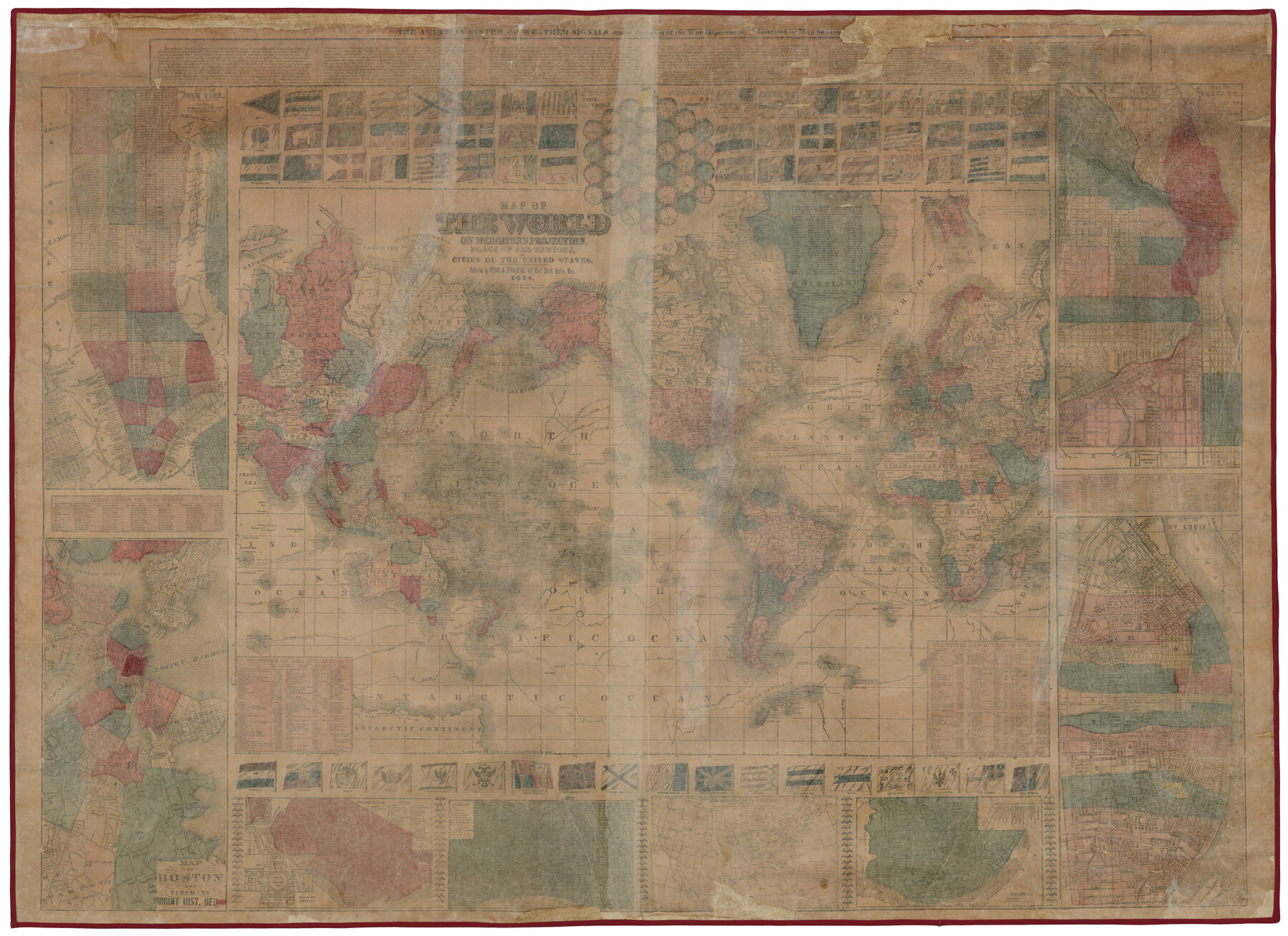
Map of the World on Mercator's Projection, flags of all nations and cities of the United States
[Multiple insets showing New York, Boston, Washington, Philadelphia, Cincinnati, St. Louis, Chicago] / [Inset:] War Department Weather Map
-
Map/Doc
93914
-
Collection
Holcomb Map Collection
-
Object Dates
1874 (Creation Date)
-
People and Organizations
Perry and Spaulding (Publisher)
-
Subjects
Atlas World
-
Height x Width
40.4 x 55.6 inches
102.6 x 141.2 cm
-
Comments
Courtesy of Frank and Carol Holcomb.
Part of: Holcomb Map Collection
J. De Cordova's Map of the State of Texas Compiled from the records of the General Land Office of the State

Print $20.00
- Digital $50.00
J. De Cordova's Map of the State of Texas Compiled from the records of the General Land Office of the State
1854
Size 25.6 x 23.4 inches
Map/Doc 93903
Traveller's Map of the State of Texas

Print $20.00
- Digital $50.00
Traveller's Map of the State of Texas
1867
Size 43.4 x 41.6 inches
Map/Doc 93906
Pressler's Map of Texas

Print $2.00
- Digital $50.00
Pressler's Map of Texas
1867
Size 9.0 x 6.0 inches
Map/Doc 93920
Bird's Eye View of the City of Houston, Texas

Print $20.00
- Digital $50.00
Bird's Eye View of the City of Houston, Texas
1873
Size 25.2 x 31.5 inches
Map/Doc 93908
Map of the State of Texas from the Latest Authorities

Print $2.00
- Digital $50.00
Map of the State of Texas from the Latest Authorities
1854
Size 5.2 x 3.5 inches
Map/Doc 93902
Bowles's New Pocket Map of America divided into its Provinces, Colonies, States, Governments &c. exhibiting the British and Spanish Empires therein; together with the Territories belonging to the French, Dutch, Danes & Portuguese

Print $20.00
- Digital $50.00
Bowles's New Pocket Map of America divided into its Provinces, Colonies, States, Governments &c. exhibiting the British and Spanish Empires therein; together with the Territories belonging to the French, Dutch, Danes & Portuguese
1784
Size 21.3 x 23.1 inches
Map/Doc 93838
The Scarborough Company's New Railroad, Post Office & County Map of Texas, Oklahoma and Indian Territory Compiled from the Latest Government Surveys and Original Sources

Print $20.00
- Digital $50.00
The Scarborough Company's New Railroad, Post Office & County Map of Texas, Oklahoma and Indian Territory Compiled from the Latest Government Surveys and Original Sources
1904
Size 42.8 x 46.6 inches
Map/Doc 93911
The State of Texas

Print $20.00
- Digital $50.00
The State of Texas
1845
Size 18.9 x 23.2 inches
Map/Doc 93870
Genl. Austins Map of Texas With Parts of the Adjoining States

Print $20.00
- Digital $50.00
Genl. Austins Map of Texas With Parts of the Adjoining States
1840
Size 30.6 x 25.3 inches
Map/Doc 93860
Carte de la Nouvelle France ou le voit le cours des Grandes Rivieres de S. Laurens & de Mississipi

Print $20.00
- Digital $50.00
Carte de la Nouvelle France ou le voit le cours des Grandes Rivieres de S. Laurens & de Mississipi
1720
Size 25.9 x 41.5 inches
Map/Doc 93822
A New Map of Texas

Print $20.00
- Digital $50.00
A New Map of Texas
1841
Size 17.6 x 16.2 inches
Map/Doc 93862
Nova Totivs Americae Descriptio

Print $20.00
- Digital $50.00
Nova Totivs Americae Descriptio
1666
Size 21.2 x 24.3 inches
Map/Doc 93818
You may also like
Sutton County Working Sketch 10

Print $40.00
- Digital $50.00
Sutton County Working Sketch 10
1972
Size 71.0 x 42.9 inches
Map/Doc 62353
Erath County Working Sketch 39

Print $20.00
- Digital $50.00
Erath County Working Sketch 39
1976
Size 26.9 x 28.0 inches
Map/Doc 69120
Jones County Sketch File 5a

Print $20.00
- Digital $50.00
Jones County Sketch File 5a
1857
Size 18.4 x 23.5 inches
Map/Doc 11896
Map of Part of Texas Prison System, Blue Ridge State Farm near Camp No. 1 Showing Buildings and Property Lines

Print $20.00
- Digital $50.00
Map of Part of Texas Prison System, Blue Ridge State Farm near Camp No. 1 Showing Buildings and Property Lines
Size 20.3 x 25.4 inches
Map/Doc 62980
Reagan County Boundary File 1c

Print $56.00
- Digital $50.00
Reagan County Boundary File 1c
Size 9.2 x 8.2 inches
Map/Doc 58171
Marion County Sketch File 2

Print $4.00
- Digital $50.00
Marion County Sketch File 2
1853
Size 8.3 x 14.2 inches
Map/Doc 30564
Galveston Harbor, Texas - U.S. Harbor Lines - Galveston Harbor, Galveston Channel, Channel from Galveston Harbor to Texas City and Channel to Port Bolivar

Print $20.00
- Digital $50.00
Galveston Harbor, Texas - U.S. Harbor Lines - Galveston Harbor, Galveston Channel, Channel from Galveston Harbor to Texas City and Channel to Port Bolivar
1939
Size 39.4 x 26.7 inches
Map/Doc 73631
Crockett County Working Sketch 8

Print $20.00
- Digital $50.00
Crockett County Working Sketch 8
1903
Size 15.2 x 30.3 inches
Map/Doc 68341
McLennan County Sketch File 31

Print $22.00
- Digital $50.00
McLennan County Sketch File 31
Size 14.2 x 17.2 inches
Map/Doc 31306
Amistad International Reservoir on Rio Grande 74a

Print $20.00
- Digital $50.00
Amistad International Reservoir on Rio Grande 74a
1949
Size 28.6 x 40.0 inches
Map/Doc 75502
Galveston County NRC Article 33.136 Sketch 28

Print $26.00
- Digital $50.00
Galveston County NRC Article 33.136 Sketch 28
2004
Size 35.3 x 25.0 inches
Map/Doc 82909
Montgomery County Rolled Sketch 42

Print $20.00
- Digital $50.00
Montgomery County Rolled Sketch 42
1939
Size 13.9 x 20.1 inches
Map/Doc 6819