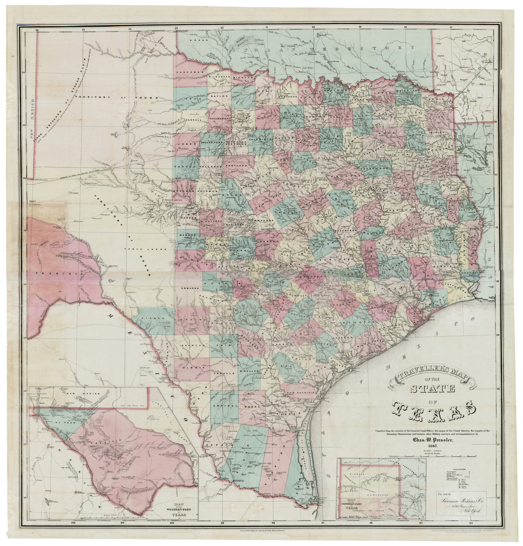
Traveller's Map of the State of Texas
-
Map/Doc
93906
-
Collection
Holcomb Map Collection
-
Object Dates
1867 (Creation Date)
-
People and Organizations
Swenson Perkins and Co. (Publisher)
American Photo-Lithographic Company (Printer)
Chas. W. Pressler (Compiler)
-
Subjects
State of Texas
-
Height x Width
43.4 x 41.6 inches
110.2 x 105.7 cm
-
Scale
1:1,000,000
-
Comments
See 93920 for original cover for this map. Courtesy of Frank and Carol Holcomb.
-
URLs
https://medium.com/save-texas-history/travellers-sic-map-of-the-state-of-texas-a376d4b88923
Related maps
Pressler's Map of Texas

Print $2.00
- Digital $50.00
Pressler's Map of Texas
1867
Size 9.0 x 6.0 inches
Map/Doc 93920
Part of: Holcomb Map Collection
Novissima et Accuratissima Totius Americae Descriptio

Print $20.00
- Digital $50.00
Novissima et Accuratissima Totius Americae Descriptio
1677
Size 20.9 x 25.0 inches
Map/Doc 93819
America with those known parts in that unknowne worlde both people and manner of buildings

Print $20.00
- Digital $50.00
America with those known parts in that unknowne worlde both people and manner of buildings
1626
Size 17.1 x 22.2 inches
Map/Doc 93816
Map of the State of Texas from the Latest Authorities

Print $20.00
- Digital $50.00
Map of the State of Texas from the Latest Authorities
1854
Size 13.1 x 16.1 inches
Map/Doc 93901
J. De Cordova's Map of the State of Texas Compiled from the records of the General Land Office of the State

Print $20.00
- Digital $50.00
J. De Cordova's Map of the State of Texas Compiled from the records of the General Land Office of the State
1849
Size 33.7 x 36.1 inches
Map/Doc 94026
Texas, Oregon and California [Cover and accompaniment]
![93873, Texas, Oregon and California [Cover and accompaniment], Holcomb Digital Map Collection](https://historictexasmaps.com/wmedia_w700/pdf_converted_jpg/qi_pdf_thumbnail_38543.jpg)
Print $108.00
- Digital $50.00
Texas, Oregon and California [Cover and accompaniment]
1846
Size 5.4 x 3.4 inches
Map/Doc 93873
Map of Texas with parts of the Adjoining States

Print $20.00
- Digital $50.00
Map of Texas with parts of the Adjoining States
1830
Size 29.6 x 24.1 inches
Map/Doc 94440
The State of Texas

Print $20.00
- Digital $50.00
The State of Texas
1845
Size 18.9 x 23.2 inches
Map/Doc 93870
Carta Geografica General de la Republica Mexicana

Print $40.00
- Digital $50.00
Carta Geografica General de la Republica Mexicana
1845
Size 38.1 x 52.9 inches
Map/Doc 96438
Map of the World on Mercator's Projection, flags of all nations and cities of the United States

Print $40.00
- Digital $50.00
Map of the World on Mercator's Projection, flags of all nations and cities of the United States
1874
Size 40.4 x 55.6 inches
Map/Doc 93914
America siue India Nova ad magnae Gerardi Mercatoris aui Vniversalis imitationem in compendium redacta

Print $20.00
- Digital $50.00
America siue India Nova ad magnae Gerardi Mercatoris aui Vniversalis imitationem in compendium redacta
1585
Size 16.9 x 20.2 inches
Map/Doc 93808
Qvivirae Regnv, cum alijs verfus Borea

Print $20.00
- Digital $50.00
Qvivirae Regnv, cum alijs verfus Borea
1593
Size 16.7 x 11.7 inches
Map/Doc 93833
Texas Nach den besten Quellen

Print $20.00
- Digital $50.00
Texas Nach den besten Quellen
1846
Size 15.4 x 18.7 inches
Map/Doc 93874
You may also like
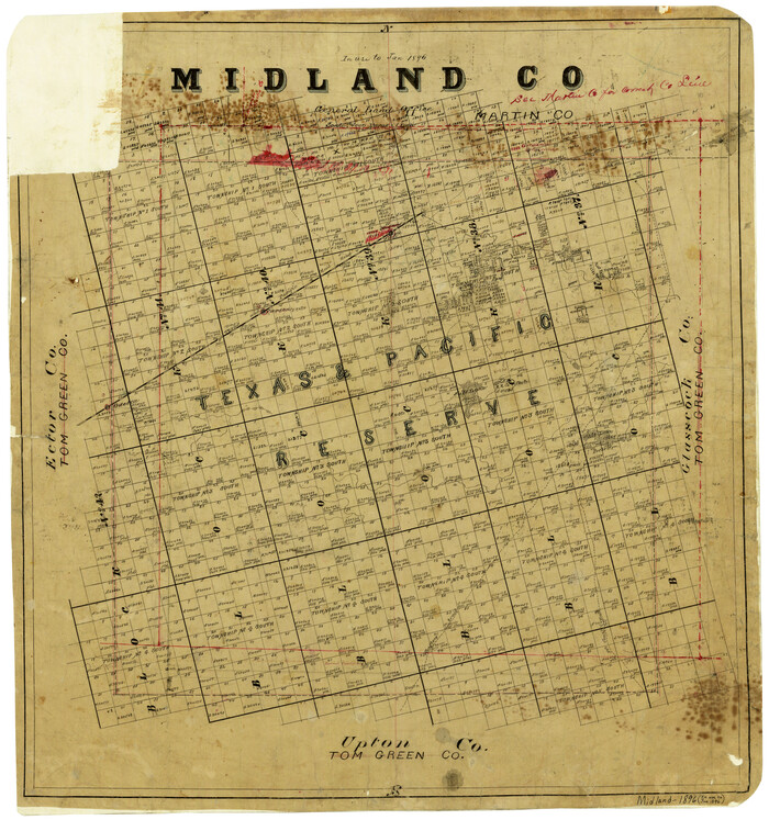
Midland County
Print $20.00
- Digital $50.00
Midland County
1896
Size 21.5 x 20.0 inches
Map/Doc 3877
[Surveys in Williamson County]
![78376, [Surveys in Williamson County], General Map Collection](https://historictexasmaps.com/wmedia_w700/maps/78376.tif.jpg)
Print $2.00
- Digital $50.00
[Surveys in Williamson County]
1847
Size 12.6 x 8.3 inches
Map/Doc 78376
Calhoun County Sketch File 17

Print $4.00
- Digital $50.00
Calhoun County Sketch File 17
Size 5.1 x 8.4 inches
Map/Doc 35984
Uvalde County Working Sketch 2

Print $20.00
- Digital $50.00
Uvalde County Working Sketch 2
1911
Size 23.3 x 21.3 inches
Map/Doc 72072
[Sketch of surveys in the vicinity of sections 171 and 172 along Pedernales]
![91882, [Sketch of surveys in the vicinity of sections 171 and 172 along Pedernales], Twichell Survey Records](https://historictexasmaps.com/wmedia_w700/maps/91882-1.tif.jpg)
Print $20.00
- Digital $50.00
[Sketch of surveys in the vicinity of sections 171 and 172 along Pedernales]
Size 17.2 x 12.9 inches
Map/Doc 91882
Jefferson County Rolled Sketch 57

Print $20.00
- Digital $50.00
Jefferson County Rolled Sketch 57
1874
Size 25.9 x 18.6 inches
Map/Doc 6408
Flight Mission No. BQR-20K, Frame 9, Brazoria County

Print $20.00
- Digital $50.00
Flight Mission No. BQR-20K, Frame 9, Brazoria County
1952
Size 18.6 x 22.4 inches
Map/Doc 84111
Kinney County Rolled Sketch 2

Print $20.00
- Digital $50.00
Kinney County Rolled Sketch 2
Size 24.5 x 36.2 inches
Map/Doc 6534
[I. & G. N. Block 1]
![91572, [I. & G. N. Block 1], Twichell Survey Records](https://historictexasmaps.com/wmedia_w700/maps/91572-1.tif.jpg)
Print $20.00
- Digital $50.00
[I. & G. N. Block 1]
Size 17.5 x 13.6 inches
Map/Doc 91572
Midland County Boundary File 4b

Print $18.00
- Digital $50.00
Midland County Boundary File 4b
Size 13.6 x 9.0 inches
Map/Doc 57186
Val Verde County Sketch File 51

Print $10.00
- Digital $50.00
Val Verde County Sketch File 51
1959
Size 9.8 x 8.7 inches
Map/Doc 39320
Grimes County Working Sketch 11

Print $20.00
- Digital $50.00
Grimes County Working Sketch 11
1981
Size 22.7 x 22.6 inches
Map/Doc 63302