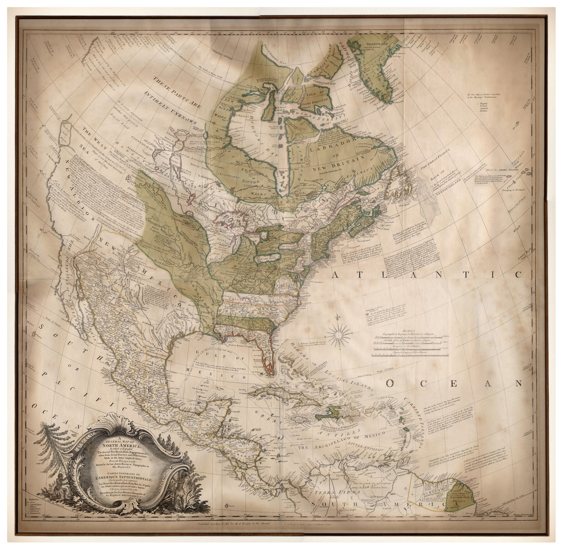
A General Map of North America; In which is Express'd the several New Roads, Forts, Engagements, & c. taken from Actual Surveys and Observations Made in the Army employ'd there
-
Map/Doc
93827
-
Collection
Holcomb Map Collection
-
Object Dates
1761 (Creation Date)
-
People and Organizations
M. A. Rocque (Publisher)
John Rocque (Author)
-
Subjects
North America
-
Height x Width
37.6 x 38.6 inches
95.5 x 98.0 cm
-
Comments
Courtesy of Frank and Carol Holcomb.
Part of: Holcomb Map Collection
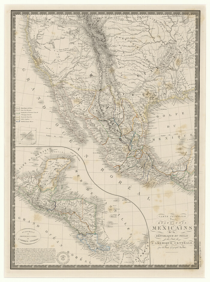
Carte Générale des États-Unis Mexicains de la République du Texas et des Etats de L'Amérique Centrale
Print $20.00
- Digital $50.00
Carte Générale des États-Unis Mexicains de la République du Texas et des Etats de L'Amérique Centrale
1844
Size 21.9 x 16.3 inches
Map/Doc 97532
America siue India Nova ad magnae Gerardi Mercatoris aui Vniversalis imitationem in compendium redacta

Print $20.00
- Digital $50.00
America siue India Nova ad magnae Gerardi Mercatoris aui Vniversalis imitationem in compendium redacta
1585
Size 16.9 x 20.2 inches
Map/Doc 93808
Mexico and Guatimala

Print $20.00
- Digital $50.00
Mexico and Guatimala
1828
Size 9.4 x 11.4 inches
Map/Doc 97524
A.R. Roessler's Latest Map of the State of Texas Exhibiting Mineral and Agricultural Districts, Post Offices & Mailroutes, Railroads projected and finished, Timber, Prairie, Swamp Lands, etc. etc. etc.

Print $20.00
- Digital $50.00
A.R. Roessler's Latest Map of the State of Texas Exhibiting Mineral and Agricultural Districts, Post Offices & Mailroutes, Railroads projected and finished, Timber, Prairie, Swamp Lands, etc. etc. etc.
1874
Size 39.9 x 44.6 inches
Map/Doc 95369
Map of the Southern States designed to accompany Smith's Geography for Schools

Print $20.00
- Digital $50.00
Map of the Southern States designed to accompany Smith's Geography for Schools
1850
Size 12.1 x 19.2 inches
Map/Doc 93888
A New Map of Texas with the Contiguous American & Mexican States

Print $20.00
- Digital $50.00
A New Map of Texas with the Contiguous American & Mexican States
1835
Size 12.9 x 15.8 inches
Map/Doc 93853
Map of the West Indies designed to accompany Smith's Geography for Schools

Print $20.00
- Digital $50.00
Map of the West Indies designed to accompany Smith's Geography for Schools
1850
Size 9.6 x 12.0 inches
Map/Doc 93893
Carte de la Nouvelle France ou le voit le cours des Grandes Rivieres de S. Laurens & de Mississipi

Print $20.00
- Digital $50.00
Carte de la Nouvelle France ou le voit le cours des Grandes Rivieres de S. Laurens & de Mississipi
1720
Size 25.9 x 41.5 inches
Map/Doc 93822
Map of the Middle States designed to accompany Smith's Geography for Schools

Print $20.00
- Digital $50.00
Map of the Middle States designed to accompany Smith's Geography for Schools
1850
Size 19.4 x 12.2 inches
Map/Doc 93887
Map of the State of Coahuila and Texas

Print $20.00
- Digital $50.00
Map of the State of Coahuila and Texas
1834
Size 13.2 x 14.7 inches
Map/Doc 93848
America Settentrionale Colle Nuoue Scoperte fin all' Anno 1688

Print $20.00
- Digital $50.00
America Settentrionale Colle Nuoue Scoperte fin all' Anno 1688
1688
Size 25.4 x 37.6 inches
Map/Doc 96506
Disturnell's New Map of the United States and Canada; showing all the canals, railroads, telegraph lines and principal stage routes

Print $20.00
- Digital $50.00
Disturnell's New Map of the United States and Canada; showing all the canals, railroads, telegraph lines and principal stage routes
1853
Size 28.1 x 40.9 inches
Map/Doc 93900
You may also like
Jefferson County Rolled Sketch 62

Print $40.00
- Digital $50.00
Jefferson County Rolled Sketch 62
1974
Size 78.4 x 43.1 inches
Map/Doc 9318
Taylor County Sketch File 3

Print $4.00
- Digital $50.00
Taylor County Sketch File 3
Size 7.5 x 8.3 inches
Map/Doc 37778
Flight Mission No. DAG-23K, Frame 167, Matagorda County

Print $20.00
- Digital $50.00
Flight Mission No. DAG-23K, Frame 167, Matagorda County
1953
Size 15.9 x 19.1 inches
Map/Doc 86505
Frio County Sketch File 11

Print $4.00
- Digital $50.00
Frio County Sketch File 11
1912
Size 8.4 x 11.2 inches
Map/Doc 23125
Harris County Sketch File 13a

Print $4.00
- Digital $50.00
Harris County Sketch File 13a
1860
Size 10.8 x 6.0 inches
Map/Doc 25357
Outer Continental Shelf Leasing Maps (Louisiana Offshore Operations)

Print $20.00
- Digital $50.00
Outer Continental Shelf Leasing Maps (Louisiana Offshore Operations)
1959
Size 17.9 x 14.0 inches
Map/Doc 76097
Crane County Working Sketch 8

Print $20.00
- Digital $50.00
Crane County Working Sketch 8
1929
Size 33.2 x 28.4 inches
Map/Doc 68285
Throckmorton County Sketch File 5a

Print $22.00
- Digital $50.00
Throckmorton County Sketch File 5a
Size 8.0 x 7.8 inches
Map/Doc 38075
[Littlefield Subdivision Blocks 657-687]
![91008, [Littlefield Subdivision Blocks 657-687], Twichell Survey Records](https://historictexasmaps.com/wmedia_w700/maps/91008-1.tif.jpg)
Print $20.00
- Digital $50.00
[Littlefield Subdivision Blocks 657-687]
Size 15.7 x 12.1 inches
Map/Doc 91008
El Paso County Boundary File 26

Print $14.00
- Digital $50.00
El Paso County Boundary File 26
Size 14.8 x 9.3 inches
Map/Doc 53231

Real County Working Sketch 70

Print $20.00
- Digital $50.00
Real County Working Sketch 70
1976
Size 32.3 x 31.8 inches
Map/Doc 71962