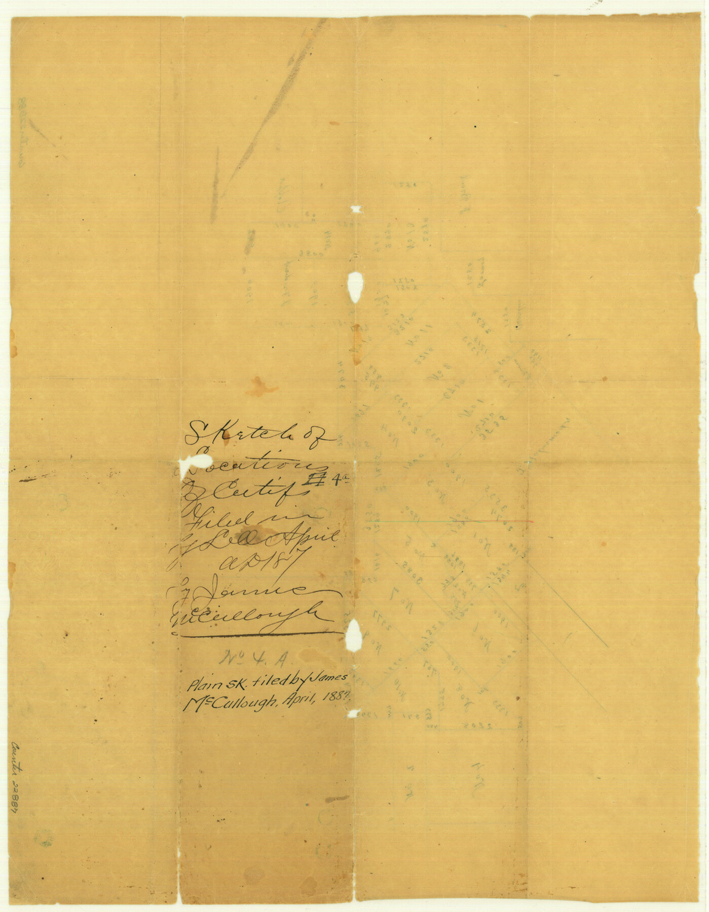
Fort Bend County Sketch File 4a
[Plain sketch in Fort Bend County]
-
Map/Doc
22887
-
Collection
General Map Collection
-
Object Dates
1887 (Creation Date)
1887 (Survey Date)
-
People and Organizations
James McCullough ()
-
Counties
Fort Bend
-
Subjects
Surveying Sketch File
-
Height x Width
15.8 x 12.3 inches
40.1 x 31.2 cm
-
Medium
paper, manuscript
Part of: General Map Collection
Live Oak County Working Sketch 17

Print $20.00
- Digital $50.00
Live Oak County Working Sketch 17
1960
Size 29.5 x 26.9 inches
Map/Doc 70602

Navasota River, Springfield Sheet

Print $20.00
- Digital $50.00
Navasota River, Springfield Sheet
1934
Size 41.5 x 37.8 inches
Map/Doc 65074
Carson County Working Sketch 4

Print $20.00
- Digital $50.00
Carson County Working Sketch 4
1952
Size 26.1 x 37.0 inches
Map/Doc 67875
Lee County Working Sketch 5

Print $20.00
- Digital $50.00
Lee County Working Sketch 5
1975
Size 38.5 x 36.2 inches
Map/Doc 70384
Hunt County Rolled Sketch 5

Print $20.00
- Digital $50.00
Hunt County Rolled Sketch 5
1956
Size 22.9 x 23.0 inches
Map/Doc 6271


Culberson County Working Sketch 13

Print $20.00
- Digital $50.00
Culberson County Working Sketch 13
1922
Size 25.7 x 21.3 inches
Map/Doc 68465
Hudspeth county Sketch File 12a

Print $20.00
- Digital $50.00
Hudspeth county Sketch File 12a
1894
Size 13.3 x 34.7 inches
Map/Doc 11800

Map of Great Britain and Ireland engraved to illustrate Mitchell's school and family geography

Print $20.00
- Digital $50.00
Map of Great Britain and Ireland engraved to illustrate Mitchell's school and family geography
1840
Size 11.8 x 9.5 inches
Map/Doc 93503
You may also like
Eastland County Sketch File 14

Print $8.00
- Digital $50.00
Eastland County Sketch File 14
Size 11.5 x 9.2 inches
Map/Doc 21595
Jackson County Rolled Sketch 5

Print $20.00
- Digital $50.00
Jackson County Rolled Sketch 5
1914
Size 22.3 x 20.2 inches
Map/Doc 6340
J. De Cordova's Map of the State of Texas Compiled from the records of the General Land Office of the State

Print $20.00
- Digital $50.00
J. De Cordova's Map of the State of Texas Compiled from the records of the General Land Office of the State
1851
Size 34.9 x 32.0 inches
Map/Doc 442
Edwards County Working Sketch 74

Print $20.00
- Digital $50.00
Edwards County Working Sketch 74
1959
Size 23.6 x 38.4 inches
Map/Doc 68950
Preliminary Re-Plat of Lots 13-20, 45-52, 77-84, and 97-104 James Subdivision

Print $20.00
- Digital $50.00
Preliminary Re-Plat of Lots 13-20, 45-52, 77-84, and 97-104 James Subdivision
1953
Size 11.8 x 36.7 inches
Map/Doc 93222
Edwards County Sketch File 44

Print $4.00
- Digital $50.00
Edwards County Sketch File 44
1948
Size 11.4 x 8.9 inches
Map/Doc 21777
Concho County Sketch File 50

Print $20.00
- Digital $50.00
Concho County Sketch File 50
1890
Size 15.9 x 13.6 inches
Map/Doc 19217
Bird's Eye View of La Grange, Fayette County, Texas

Print $20.00
Bird's Eye View of La Grange, Fayette County, Texas
1880
Size 24.1 x 31.2 inches
Map/Doc 89096
West Part of Edwards County

Print $40.00
- Digital $50.00
West Part of Edwards County
1975
Size 58.7 x 38.5 inches
Map/Doc 73139
Polk County Sketch File 17

Print $4.00
- Digital $50.00
Polk County Sketch File 17
1861
Size 8.1 x 9.5 inches
Map/Doc 34163
PSL Field Notes for Block CS in Hartley County

PSL Field Notes for Block CS in Hartley County
Map/Doc 81656
Schleicher County Working Sketch 20
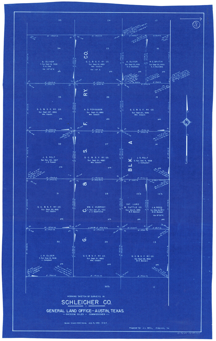
Print $20.00
- Digital $50.00
Schleicher County Working Sketch 20
1951
Size 33.8 x 21.2 inches
Map/Doc 63822