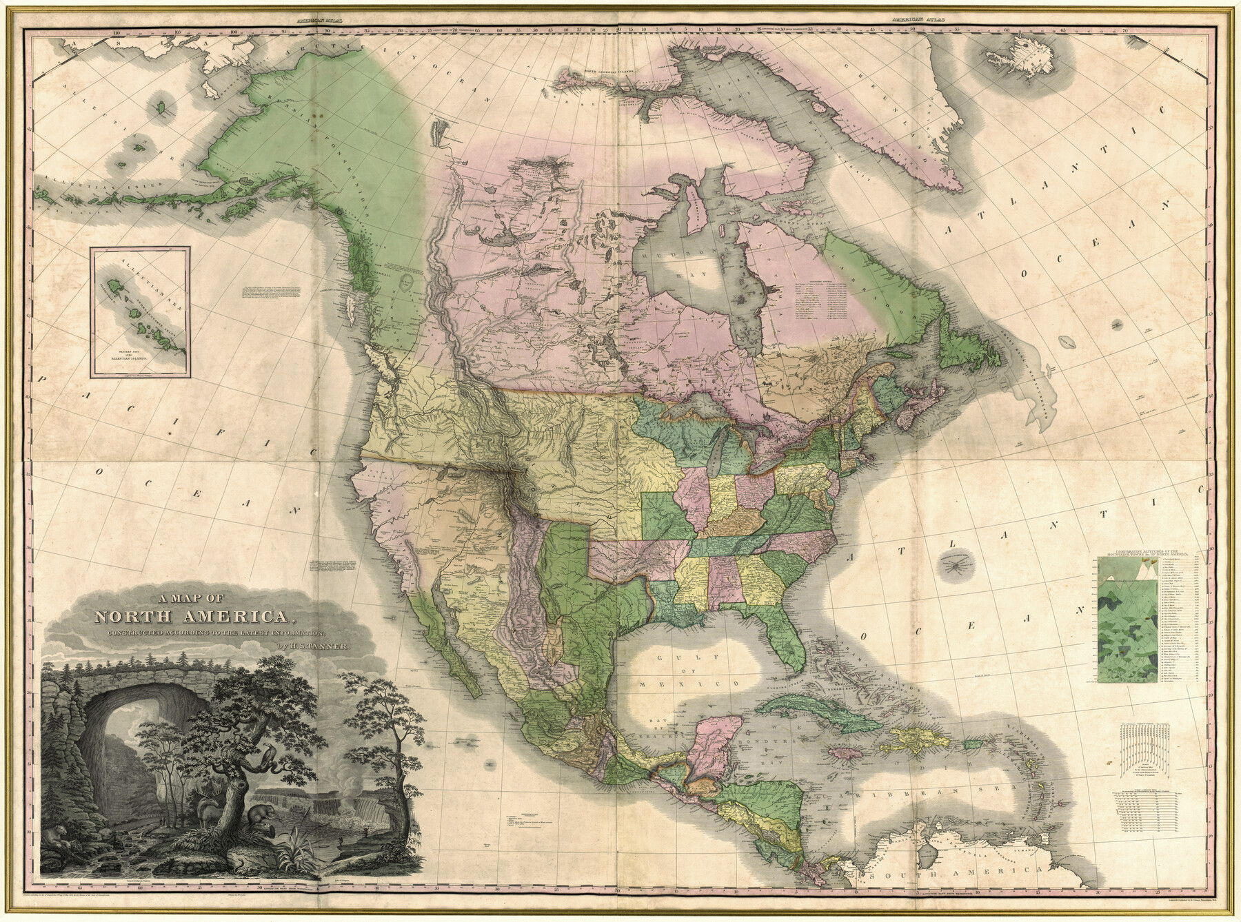
A Map of North America, constructed according to the latest information
-
Map/Doc
93845
-
Collection
Holcomb Map Collection
-
Object Dates
1822 (Creation Date)
-
People and Organizations
William Duffee (Printer)
H.S. Tanner (Author)
-
Subjects
North America
-
Height x Width
44.4 x 59.6 inches
112.8 x 151.4 cm
-
Comments
Courtesy of Frank and Carol Holcomb.
-
URLs
https://medium.com/save-texas-history/a-map-of-north-america-constructed-according-to-the-latest-information-1822-54639ffab458#.ug9tkils9
Part of: Holcomb Map Collection
J. De Cordova's Map of the State of Texas Compiled from the records of the General Land Office of the State

Print $2.00
- Digital $50.00
J. De Cordova's Map of the State of Texas Compiled from the records of the General Land Office of the State
1855
Size 6.8 x 4.0 inches
Map/Doc 93912
Colton's New Map of the State of Texas, the Indian Territory and adjoining portions of New Mexico, Louisiana and Arkansas

Print $20.00
- Digital $50.00
Colton's New Map of the State of Texas, the Indian Territory and adjoining portions of New Mexico, Louisiana and Arkansas
1882
Size 32.8 x 37.3 inches
Map/Doc 93909
America siue India Nova ad magnae Gerardi Mercatoris aui Vniversalis imitationem in compendium redacta

Print $20.00
- Digital $50.00
America siue India Nova ad magnae Gerardi Mercatoris aui Vniversalis imitationem in compendium redacta
1585
Size 16.9 x 20.2 inches
Map/Doc 93808
[Map of the Texas & Pacific Railway and connections]
![95414, [Map of the Texas & Pacific Railway and connections], Holcomb Digital Map Collection](https://historictexasmaps.com/wmedia_w700/maps/95414.tif.jpg)
Print $20.00
- Digital $50.00
[Map of the Texas & Pacific Railway and connections]
1902
Size 18.0 x 37.0 inches
Map/Doc 95414
America sive novvs orbis respectv evropaeorvm inferior globi terrestris pars 1596

Print $20.00
- Digital $50.00
America sive novvs orbis respectv evropaeorvm inferior globi terrestris pars 1596
1596
Size 14.7 x 18.1 inches
Map/Doc 93809
Map of Texas compiled from surveys at the Land Office of Texas

Print $20.00
- Digital $50.00
Map of Texas compiled from surveys at the Land Office of Texas
1851
Size 26.7 x 19.1 inches
Map/Doc 96431
Map of Michigan and Wisconsin designed to accompany Smith's Geography for Schools

Print $20.00
- Digital $50.00
Map of Michigan and Wisconsin designed to accompany Smith's Geography for Schools
1850
Size 9.7 x 12.1 inches
Map/Doc 93890
J. De Cordova's Map of the State of Texas Compiled from the records of the General Land Office of the State

Print $20.00
- Digital $50.00
J. De Cordova's Map of the State of Texas Compiled from the records of the General Land Office of the State
1854
Size 25.6 x 23.4 inches
Map/Doc 93903
Carte du Mexique et de la Floride des Terres Angloises et des Isles Antilles du cours et des environs de la Riviere de Mississipi

Print $20.00
- Digital $50.00
Carte du Mexique et de la Floride des Terres Angloises et des Isles Antilles du cours et des environs de la Riviere de Mississipi
1703
Size 19.0 x 25.8 inches
Map/Doc 96519
America with those known parts in that unknowne worlde both people and manner of buildings

Print $20.00
- Digital $50.00
America with those known parts in that unknowne worlde both people and manner of buildings
1626
Size 17.1 x 22.2 inches
Map/Doc 93816
Burlington Route

Print $20.00
- Digital $50.00
Burlington Route
1892
Size 34.9 x 47.7 inches
Map/Doc 93910
Map of Texas to accompany "Brady's Glimpses of Texas"

Print $20.00
- Digital $50.00
Map of Texas to accompany "Brady's Glimpses of Texas"
1871
Size 13.0 x 16.1 inches
Map/Doc 93907
You may also like
Cottle County Sketch File 11

Print $40.00
- Digital $50.00
Cottle County Sketch File 11
Size 12.9 x 13.3 inches
Map/Doc 19489
Freestone County Boundary File 30b

Print $20.00
- Digital $50.00
Freestone County Boundary File 30b
Size 43.9 x 12.4 inches
Map/Doc 53598
Working Sketch of surveys in Mason, Kimble & Menard Counties

Print $20.00
- Digital $50.00
Working Sketch of surveys in Mason, Kimble & Menard Counties
1900
Size 32.1 x 42.4 inches
Map/Doc 75805
Ward County Working Sketch 1

Print $20.00
- Digital $50.00
Ward County Working Sketch 1
1937
Size 24.7 x 24.5 inches
Map/Doc 72307
Young County Working Sketch 1

Print $20.00
- Digital $50.00
Young County Working Sketch 1
1960
Size 31.1 x 41.9 inches
Map/Doc 62024
Throckmorton County

Print $20.00
- Digital $50.00
Throckmorton County
1885
Size 24.9 x 18.7 inches
Map/Doc 4080
[Reverse of] Plan of the City of Austin
![76228, [Reverse of] Plan of the City of Austin, Texas State Library and Archives](https://historictexasmaps.com/wmedia_w700/maps/76228.tif.jpg)
Print $20.00
[Reverse of] Plan of the City of Austin
1839
Size 19.2 x 24.3 inches
Map/Doc 76228
Brewster County Working Sketch 55

Print $40.00
- Digital $50.00
Brewster County Working Sketch 55
1953
Size 51.1 x 27.5 inches
Map/Doc 67656

Jasper County Sketch File 24

Print $4.00
- Digital $50.00
Jasper County Sketch File 24
1925
Size 10.9 x 8.3 inches
Map/Doc 27824
Wise County Working Sketch 24

Print $40.00
- Digital $50.00
Wise County Working Sketch 24
1983
Size 37.1 x 58.2 inches
Map/Doc 72638
Hardin County Sketch File 66

Print $20.00
- Digital $50.00
Hardin County Sketch File 66
1948
Size 19.5 x 35.8 inches
Map/Doc 11639