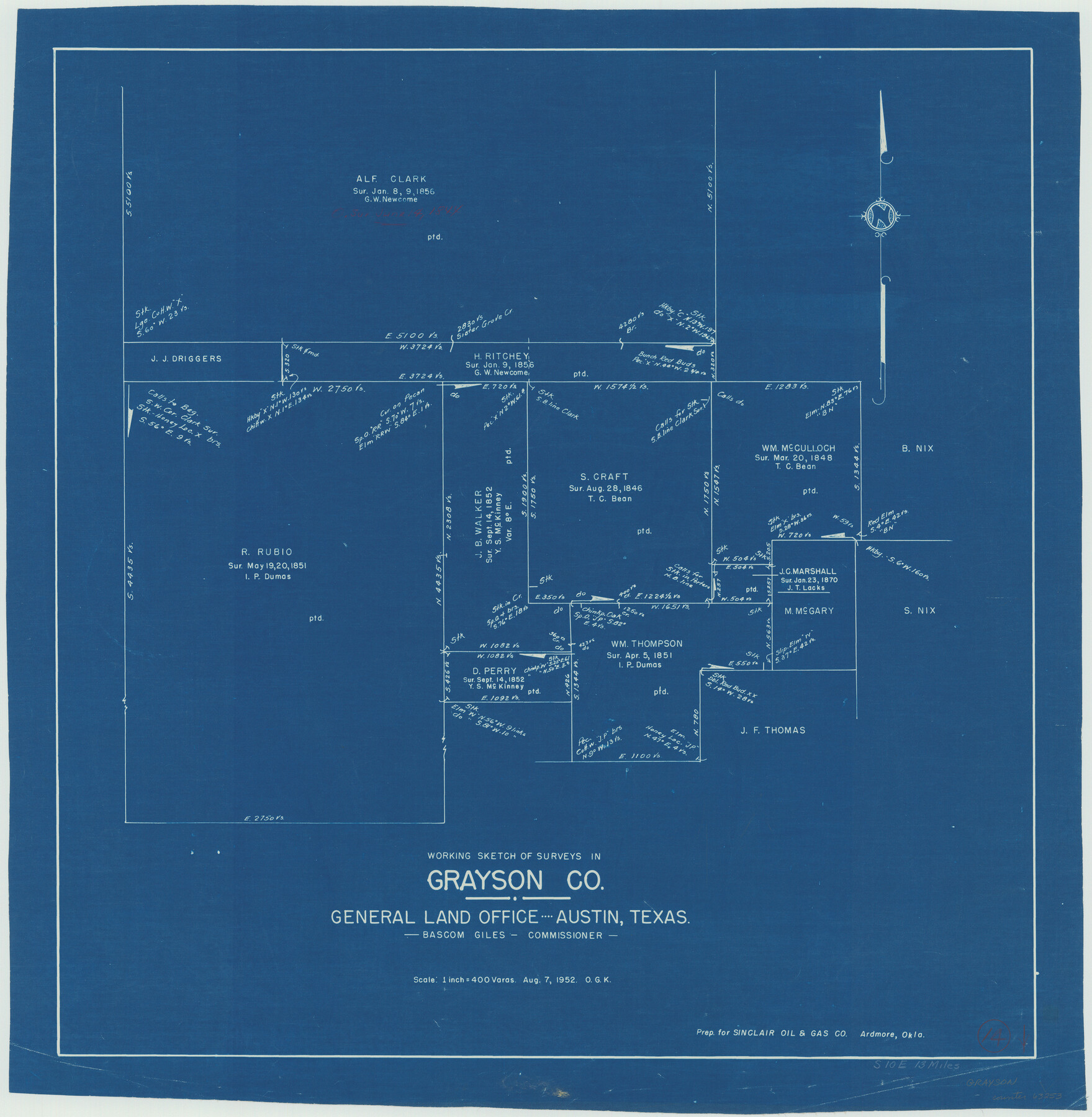
Grayson County Working Sketch 14
-
Map/Doc
63253
-
Collection
General Map Collection
-
Object Dates
8/7/1952 (Creation Date)
-
People and Organizations
Otto G. Kurio (Draftsman)
-
Counties
Grayson
-
Subjects
Surveying Working Sketch
-
Height x Width
23.9 x 23.3 inches
60.7 x 59.2 cm
-
Scale
1" = 400 varas
Part of: General Map Collection
Hardin County Working Sketch 39, part 2

Print $40.00
- Digital $50.00
Hardin County Working Sketch 39, part 2
1985
Size 36.0 x 48.5 inches
Map/Doc 63438
Comanche County

Print $20.00
- Digital $50.00
Comanche County
1896
Size 40.5 x 45.1 inches
Map/Doc 66783

Franklin County Sketch File 2a

Print $6.00
- Digital $50.00
Franklin County Sketch File 2a
1857
Size 8.6 x 10.5 inches
Map/Doc 23012
Texas Aranzas-Bay [sic]
![145, Texas Aranzas-Bay [sic], General Map Collection](https://historictexasmaps.com/wmedia_w700/maps/145.tif.jpg)
Print $20.00
- Digital $50.00
Texas Aranzas-Bay [sic]
1832
Size 21.4 x 15.5 inches
Map/Doc 145
Howard County Boundary File 3

Print $51.00
- Digital $50.00
Howard County Boundary File 3
Size 9.3 x 4.5 inches
Map/Doc 55130
McMullen County Working Sketch Graphic Index

Print $40.00
- Digital $50.00
McMullen County Working Sketch Graphic Index
1967
Size 49.4 x 34.6 inches
Map/Doc 76638
Map of Stephens Buchanan County north of the Clearfork of the Brazos River, Young- the balance Milam- Land- District

Print $20.00
- Digital $50.00
Map of Stephens Buchanan County north of the Clearfork of the Brazos River, Young- the balance Milam- Land- District
1859
Size 24.4 x 19.6 inches
Map/Doc 4052
Travis County Sketch File 2

Print $4.00
- Digital $50.00
Travis County Sketch File 2
1851
Size 8.2 x 9.9 inches
Map/Doc 38271
Flight Mission No. DQO-1K, Frame 156, Galveston County

Print $20.00
- Digital $50.00
Flight Mission No. DQO-1K, Frame 156, Galveston County
1952
Size 18.8 x 22.4 inches
Map/Doc 85009
Index sheet to accompany map of survey for connecting the inland waters along margin of the Gulf of Mexico from Donaldsonville in Louisiana to the Rio Grande River in Texas

Print $20.00
- Digital $50.00
Index sheet to accompany map of survey for connecting the inland waters along margin of the Gulf of Mexico from Donaldsonville in Louisiana to the Rio Grande River in Texas
1874
Size 18.2 x 27.1 inches
Map/Doc 72695
Pecos County Working Sketch 36

Print $20.00
- Digital $50.00
Pecos County Working Sketch 36
1939
Size 47.4 x 38.8 inches
Map/Doc 71508
You may also like
Flight Mission No. CRK-7P, Frame 132, Refugio County

Print $20.00
- Digital $50.00
Flight Mission No. CRK-7P, Frame 132, Refugio County
1956
Size 18.3 x 22.1 inches
Map/Doc 86955
[Sketch showing the Rio Grande with towns and features annotated]
![72896, [Sketch showing the Rio Grande with towns and features annotated], General Map Collection](https://historictexasmaps.com/wmedia_w700/maps/72896.tif.jpg)
Print $20.00
- Digital $50.00
[Sketch showing the Rio Grande with towns and features annotated]
1854
Size 24.1 x 18.2 inches
Map/Doc 72896
Correct Map of Lamb County, Texas

Print $40.00
- Digital $50.00
Correct Map of Lamb County, Texas
1914
Size 47.1 x 57.1 inches
Map/Doc 89954
Jackson County Boundary File 2

Print $22.00
- Digital $50.00
Jackson County Boundary File 2
Size 8.6 x 4.1 inches
Map/Doc 55437
Kendall County Working Sketch 11

Print $20.00
- Digital $50.00
Kendall County Working Sketch 11
1954
Size 34.0 x 24.8 inches
Map/Doc 66683
[Sketch for Mineral Application 35981 - Liberty County, John Mecom]
![65617, [Sketch for Mineral Application 35981 - Liberty County, John Mecom], General Map Collection](https://historictexasmaps.com/wmedia_w700/maps/65617.tif.jpg)
Print $20.00
- Digital $50.00
[Sketch for Mineral Application 35981 - Liberty County, John Mecom]
1941
Size 30.2 x 26.5 inches
Map/Doc 65617
Map of Jasper County Republic of Texas

Print $20.00
- Digital $50.00
Map of Jasper County Republic of Texas
1841
Size 36.1 x 30.0 inches
Map/Doc 3712
Amarillo City Stock Yards

Print $20.00
- Digital $50.00
Amarillo City Stock Yards
Size 21.6 x 12.2 inches
Map/Doc 91745
Newton County Sketch File 7

Print $4.00
- Digital $50.00
Newton County Sketch File 7
1872
Size 6.1 x 8.3 inches
Map/Doc 32374
Flight Mission No. DIX-8P, Frame 73, Aransas County

Print $20.00
- Digital $50.00
Flight Mission No. DIX-8P, Frame 73, Aransas County
1956
Size 18.7 x 22.3 inches
Map/Doc 83904
Deaf Smith County, Texas

Print $20.00
- Digital $50.00
Deaf Smith County, Texas
1880
Size 22.9 x 25.6 inches
Map/Doc 678
Photo Index of Texas Coast - Sheet 1 of 6

Print $20.00
- Digital $50.00
Photo Index of Texas Coast - Sheet 1 of 6
1954
Size 20.0 x 24.0 inches
Map/Doc 83438