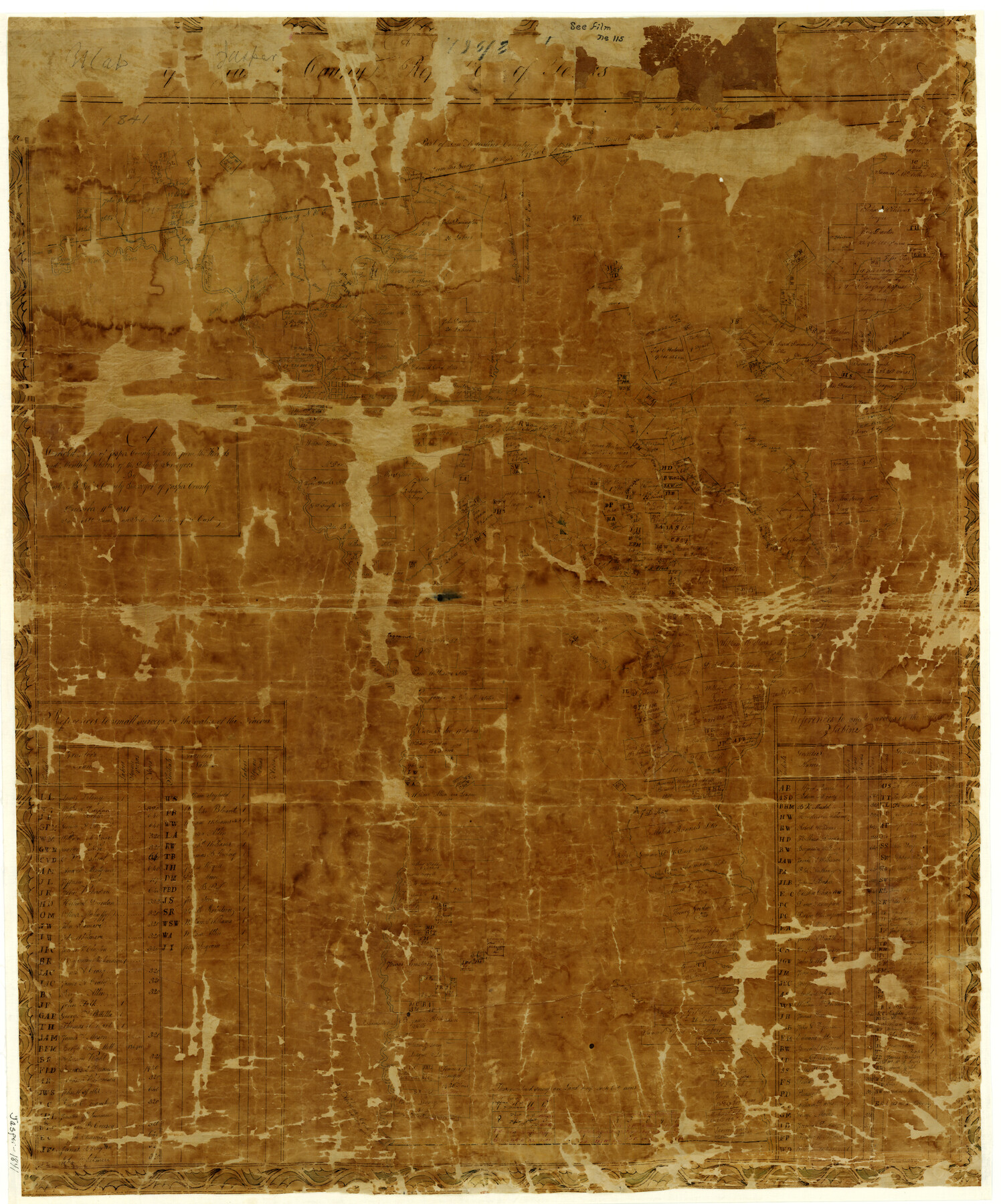
Map of Jasper County Republic of Texas
-
Map/Doc
3712
-
Collection
General Map Collection
-
Object Dates
1841 (Creation Date)
-
People and Organizations
Martin B. Lewis (Author)
-
Counties
Jasper
-
Subjects
County
-
Height x Width
36.1 x 30.0 inches
91.7 x 76.2 cm
-
Comments
Adopted in 2014 by the family and friends of Martin B. Lewis.
-
Features
Indian Creek
Duck Creek
Belgrade
Burkville
Jasper
Sabine River
Richardson's Bluff
Big Alabama Creek
Oak Creek
Cypress Creek
Zachy's Ferry
Crowley Creek
Big Cow Creek
Bevelport
Bevil Creek
Neches River
Sandy Creek
Little Cow Creek
Cat Creek
New Columbia
Angelina River
Trout Creek
Ayish Bayou
Fife Ferry
Bear Creek Bridge
Lewis' Ferry
Hulwig's Ferry
Angelina
Trot Creek
Teran
Part of: General Map Collection
Burnet County Sketch File 29

Print $4.00
- Digital $50.00
Burnet County Sketch File 29
1874
Size 10.1 x 8.1 inches
Map/Doc 16744
Marion County Working Sketch 30

Print $20.00
- Digital $50.00
Marion County Working Sketch 30
1979
Size 31.7 x 38.3 inches
Map/Doc 70806
Cherokee County Sketch File 14

Print $4.00
- Digital $50.00
Cherokee County Sketch File 14
1860
Size 8.0 x 5.9 inches
Map/Doc 18147
Map of Texas from the most recent authorities

Map of Texas from the most recent authorities
1845
Size 11.2 x 17.2 inches
Map/Doc 4333
Dallam County

Print $20.00
- Digital $50.00
Dallam County
1926
Size 34.0 x 41.0 inches
Map/Doc 77257
McLennan County Sketch File 8

Print $14.00
- Digital $50.00
McLennan County Sketch File 8
1858
Size 12.4 x 7.7 inches
Map/Doc 31251
Map of the State of Texas

Print $40.00
- Digital $50.00
Map of the State of Texas
1879
Size 102.7 x 106.6 inches
Map/Doc 16973
Pecos County Rolled Sketch 25 1/2

Print $20.00
- Digital $50.00
Pecos County Rolled Sketch 25 1/2
1888
Size 41.9 x 39.2 inches
Map/Doc 9688
Nueces County Sketch File 8

Print $22.00
- Digital $50.00
Nueces County Sketch File 8
1849
Size 8.2 x 12.4 inches
Map/Doc 32512
Val Verde County Working Sketch 106

Print $20.00
- Digital $50.00
Val Verde County Working Sketch 106
1984
Size 30.4 x 40.8 inches
Map/Doc 72241
Polk County Working Sketch 35

Print $20.00
- Digital $50.00
Polk County Working Sketch 35
1961
Size 16.7 x 12.1 inches
Map/Doc 71652
Lipscomb County Working Sketch 4

Print $40.00
- Digital $50.00
Lipscomb County Working Sketch 4
1974
Size 51.7 x 43.8 inches
Map/Doc 70580
You may also like
Brooks County Sketch File 11

Print $14.00
- Digital $50.00
Brooks County Sketch File 11
Size 11.3 x 8.9 inches
Map/Doc 16573
Jim Hogg County Working Sketch 4

Print $20.00
- Digital $50.00
Jim Hogg County Working Sketch 4
1939
Size 20.9 x 25.4 inches
Map/Doc 66590
Karnes County Rolled Sketch 3

Print $20.00
- Digital $50.00
Karnes County Rolled Sketch 3
1959
Size 27.9 x 41.6 inches
Map/Doc 6454
King County Sketch File 11

Print $40.00
- Digital $50.00
King County Sketch File 11
1902
Size 13.7 x 9.1 inches
Map/Doc 29085
La Salle County Rolled Sketch 11

Print $20.00
- Digital $50.00
La Salle County Rolled Sketch 11
1947
Size 22.1 x 35.8 inches
Map/Doc 6574
Vereinigte Staaten von Nord America

Print $20.00
- Digital $50.00
Vereinigte Staaten von Nord America
1828
Size 17.6 x 21.9 inches
Map/Doc 93644
Flight Mission No. BRA-7M, Frame 13, Jefferson County

Print $20.00
- Digital $50.00
Flight Mission No. BRA-7M, Frame 13, Jefferson County
1953
Size 18.6 x 22.4 inches
Map/Doc 85464
Sketch of Liberty County

Print $2.00
- Digital $50.00
Sketch of Liberty County
1841
Size 6.8 x 8.1 inches
Map/Doc 160
Harris County Historic Topographic 7

Print $20.00
- Digital $50.00
Harris County Historic Topographic 7
1916
Size 20.4 x 23.4 inches
Map/Doc 65817
Jeff Davis County Rolled Sketch 9

Print $20.00
- Digital $50.00
Jeff Davis County Rolled Sketch 9
Size 18.3 x 22.9 inches
Map/Doc 6362
Comal County Sketch File 5

Print $4.00
- Digital $50.00
Comal County Sketch File 5
1848
Size 12.9 x 8.4 inches
Map/Doc 19006
