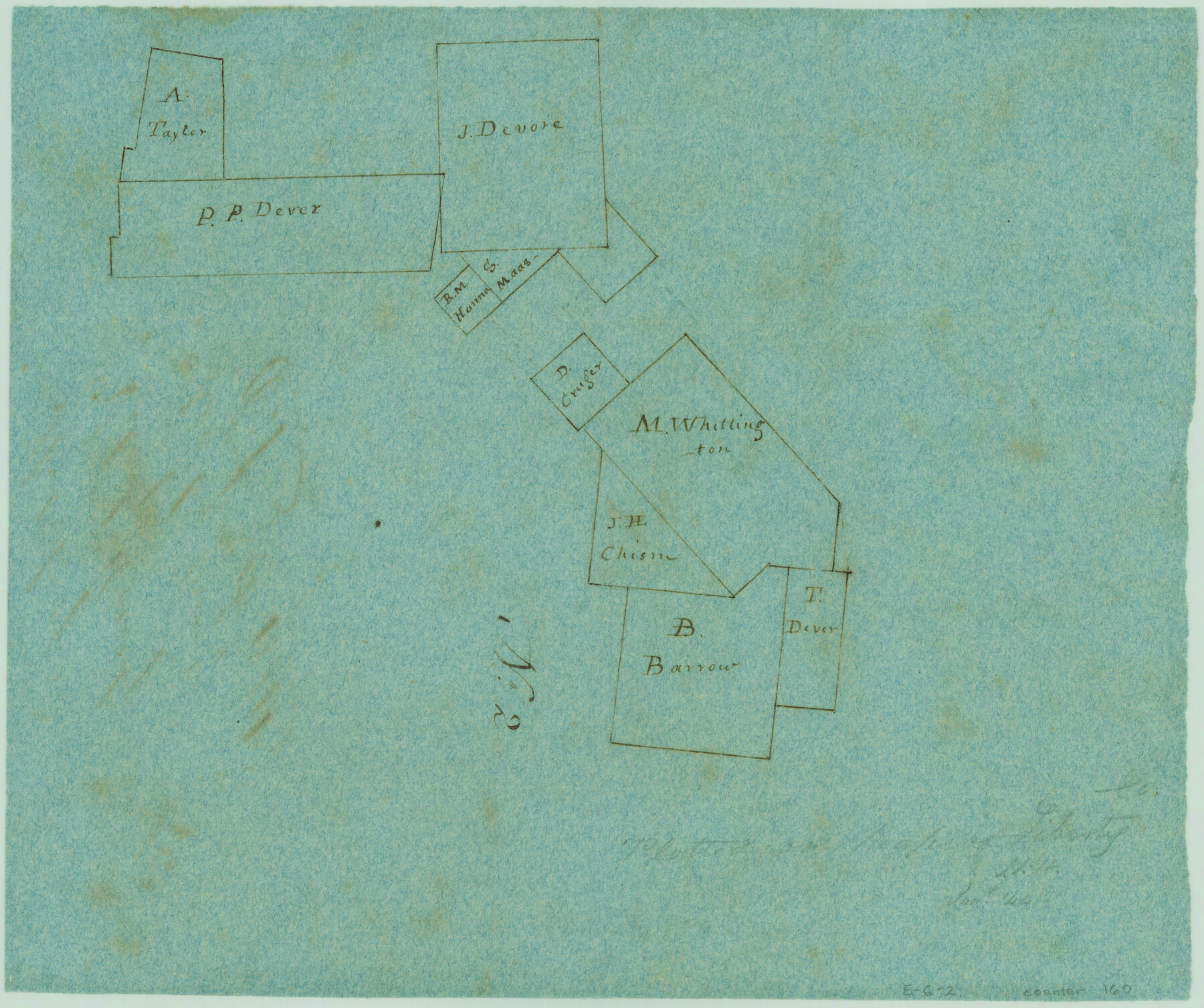
Sketch of Liberty County
Atlas E, Page 6, Sketch 2 (E-6-2)
E-6-2
-
Map/Doc
160
-
Collection
General Map Collection
-
Object Dates
1841 (Creation Date)
-
Counties
Liberty
-
Subjects
Atlas
-
Height x Width
6.8 x 8.1 inches
17.3 x 20.6 cm
-
Medium
paper, manuscript
-
Scale
[1:4000]
-
Comments
Conserved in 2004.
Part of: General Map Collection
PSL Field Notes for Blocks 87 through 98 in Culberson County

PSL Field Notes for Blocks 87 through 98 in Culberson County
Map/Doc 81664
Val Verde County Working Sketch 8

Print $20.00
- Digital $50.00
Val Verde County Working Sketch 8
1917
Size 31.4 x 32.0 inches
Map/Doc 72143
Motley County Sketch File 8 (N)

Print $6.00
- Digital $50.00
Motley County Sketch File 8 (N)
1901
Size 13.2 x 8.1 inches
Map/Doc 32016
Hopkins County Sketch File 7

Print $6.00
- Digital $50.00
Hopkins County Sketch File 7
Size 10.4 x 6.1 inches
Map/Doc 26692
Duval County Sketch File 28

Print $20.00
- Digital $50.00
Duval County Sketch File 28
1932
Size 26.2 x 24.8 inches
Map/Doc 11387
Railroad Track Map, H&TCRRCo., Falls County, Texas

Print $4.00
- Digital $50.00
Railroad Track Map, H&TCRRCo., Falls County, Texas
1918
Size 11.5 x 18.4 inches
Map/Doc 62846
United States Atlantic and Gulf Coasts Including Puerto Rico and the Virgin Islands

Print $40.00
- Digital $50.00
United States Atlantic and Gulf Coasts Including Puerto Rico and the Virgin Islands
1989
Size 21.4 x 60.4 inches
Map/Doc 73552
Duval County Working Sketch 14

Print $20.00
- Digital $50.00
Duval County Working Sketch 14
1938
Size 15.2 x 17.7 inches
Map/Doc 68727
Montgomery County Rolled Sketch 29

Print $20.00
- Digital $50.00
Montgomery County Rolled Sketch 29
1948
Size 36.4 x 31.7 inches
Map/Doc 9537
Jefferson Co.

Print $40.00
- Digital $50.00
Jefferson Co.
1978
Size 49.3 x 43.5 inches
Map/Doc 95546
Anderson County Working Sketch 3

Print $20.00
- Digital $50.00
Anderson County Working Sketch 3
Size 15.4 x 14.1 inches
Map/Doc 67002
Bastrop County Sketch File 14

Print $6.00
- Digital $50.00
Bastrop County Sketch File 14
2018
Size 11.0 x 8.5 inches
Map/Doc 95248
You may also like

Travis County State Real Property Sketch 5

Print $20.00
- Digital $50.00
Travis County State Real Property Sketch 5
1990
Size 25.4 x 37.5 inches
Map/Doc 61696
Flight Mission No. CGI-3N, Frame 73, Cameron County

Print $20.00
- Digital $50.00
Flight Mission No. CGI-3N, Frame 73, Cameron County
1954
Size 18.4 x 22.4 inches
Map/Doc 84567
[Sketch showing Block 42, Sections 221 and 222 and Block H, Sections 7 and 9]
![91714, [Sketch showing Block 42, Sections 221 and 222 and Block H, Sections 7 and 9], Twichell Survey Records](https://historictexasmaps.com/wmedia_w700/maps/91714-1.tif.jpg)
Print $2.00
- Digital $50.00
[Sketch showing Block 42, Sections 221 and 222 and Block H, Sections 7 and 9]
1919
Size 5.6 x 5.0 inches
Map/Doc 91714
Duval County Sketch File 6b

Print $5.00
- Digital $50.00
Duval County Sketch File 6b
1875
Size 8.3 x 10.8 inches
Map/Doc 21290
Henderson County

Print $40.00
- Digital $50.00
Henderson County
1988
Size 30.8 x 63.0 inches
Map/Doc 77310
Taylor County Working Sketch 6

Print $20.00
- Digital $50.00
Taylor County Working Sketch 6
1951
Size 35.4 x 31.9 inches
Map/Doc 69616
Chambers County Sketch File 35

Print $14.00
- Digital $50.00
Chambers County Sketch File 35
Size 7.1 x 7.6 inches
Map/Doc 17625
Galveston County Rolled Sketch 37

Print $20.00
- Digital $50.00
Galveston County Rolled Sketch 37
Size 26.8 x 16.5 inches
Map/Doc 5971
Garza County Sketch File 24

Print $8.00
- Digital $50.00
Garza County Sketch File 24
Size 9.1 x 7.7 inches
Map/Doc 24083
Chambers County Sketch File 23

Print $2.00
- Digital $50.00
Chambers County Sketch File 23
1878
Size 10.0 x 7.9 inches
Map/Doc 17597
[Sketch showing vicinity of Wm. McCutcheon League near the Bastrop-Caldwell County Line]
![90144, [Sketch showing vicinity of Wm. McCutcheon League near the Bastrop-Caldwell County Line], Twichell Survey Records](https://historictexasmaps.com/wmedia_w700/maps/90144-1.tif.jpg)
Print $2.00
- Digital $50.00
[Sketch showing vicinity of Wm. McCutcheon League near the Bastrop-Caldwell County Line]
1923
Size 7.7 x 12.9 inches
Map/Doc 90144