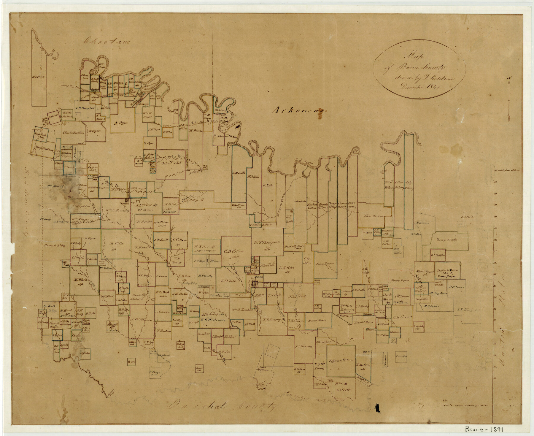
Map of Bowie County
-
Map/Doc
3316
-
Collection
General Map Collection
-
Object Dates
1841 (Creation Date)
-
People and Organizations
Texas General Land Office (Publisher)
F. Siedikum (Draftsman)
-
Counties
Bowie
-
Subjects
County
-
Height x Width
17.8 x 21.8 inches
45.2 x 55.4 cm
-
Features
Blythe's Creek
Sulphur Fork
Epperson Ferry
Stephenson Ferry
Brook's Creek
Rocky Creek
Longham's Creek
Rick's Creek
Piney Creek
Weaver's Creek
Berlin
Ward's Creek
Ross Creek
Anderson Creek
DeKalb
North Mud Creek
Mud Creek
Red Bayou
Red River
Mill Creek
Part of: General Map Collection
[Galveston, Harrisburg & San Antonio through El Paso County]
![64007, [Galveston, Harrisburg & San Antonio through El Paso County], General Map Collection](https://historictexasmaps.com/wmedia_w700/maps/64007.tif.jpg)
Print $20.00
- Digital $50.00
[Galveston, Harrisburg & San Antonio through El Paso County]
1906
Size 13.4 x 33.9 inches
Map/Doc 64007
Brooks County Working Sketch 11

Print $20.00
- Digital $50.00
Brooks County Working Sketch 11
1942
Size 41.8 x 23.5 inches
Map/Doc 67795
Flight Mission No. DCL-7C, Frame 142, Kenedy County

Print $20.00
- Digital $50.00
Flight Mission No. DCL-7C, Frame 142, Kenedy County
1943
Size 18.6 x 22.5 inches
Map/Doc 86099
Flight Mission No. CRC-4R, Frame 102, Chambers County

Print $20.00
- Digital $50.00
Flight Mission No. CRC-4R, Frame 102, Chambers County
1956
Size 18.5 x 22.4 inches
Map/Doc 84899
Dickens County Sketch File 18aa

Print $20.00
- Digital $50.00
Dickens County Sketch File 18aa
Size 17.2 x 18.2 inches
Map/Doc 11323
Flight Mission No. DCL-4C, Frame 145, Kenedy County

Print $20.00
- Digital $50.00
Flight Mission No. DCL-4C, Frame 145, Kenedy County
1943
Size 18.6 x 22.4 inches
Map/Doc 85823
Titus County Sketch File 8

Print $4.00
- Digital $50.00
Titus County Sketch File 8
1855
Size 12.7 x 7.9 inches
Map/Doc 38144
Brewster County Rolled Sketch 71

Print $20.00
- Digital $50.00
Brewster County Rolled Sketch 71
1940
Size 29.9 x 42.9 inches
Map/Doc 8491
Reyno de la Nueva España a Principios del Siglo XIX

Print $20.00
- Digital $50.00
Reyno de la Nueva España a Principios del Siglo XIX
1885
Size 25.6 x 32.7 inches
Map/Doc 93751
Map of Retrieve Plantation, Brazoria County, Texas

Print $20.00
- Digital $50.00
Map of Retrieve Plantation, Brazoria County, Texas
Size 26.6 x 28.5 inches
Map/Doc 62999
Panola County Rolled Sketch 2

Print $20.00
- Digital $50.00
Panola County Rolled Sketch 2
1944
Size 20.7 x 27.0 inches
Map/Doc 7197
Crockett County Rolled Sketch 55

Print $40.00
- Digital $50.00
Crockett County Rolled Sketch 55
Size 42.3 x 95.8 inches
Map/Doc 8718
You may also like
Stephens County Sketch File 27

Print $6.00
- Digital $50.00
Stephens County Sketch File 27
Size 9.7 x 8.5 inches
Map/Doc 37101
General Highway Map. Detail of Cities and Towns in Tarrant County, Texas. City Map, Fort Worth and vicinity, Tarrant County, Texas

Print $20.00
General Highway Map. Detail of Cities and Towns in Tarrant County, Texas. City Map, Fort Worth and vicinity, Tarrant County, Texas
1961
Size 18.2 x 25.0 inches
Map/Doc 79670
Maverick County Sketch File 1 1/2

Print $20.00
- Digital $50.00
Maverick County Sketch File 1 1/2
1875
Size 23.2 x 27.6 inches
Map/Doc 12049
Jefferson County Sketch File 3

Print $8.00
- Digital $50.00
Jefferson County Sketch File 3
1849
Size 8.2 x 7.8 inches
Map/Doc 28097
Nueces County Rolled Sketch 121

Print $32.00
Nueces County Rolled Sketch 121
1994
Size 18.2 x 24.5 inches
Map/Doc 7152
Flight Mission No. BRA-16M, Frame 70, Jefferson County

Print $20.00
- Digital $50.00
Flight Mission No. BRA-16M, Frame 70, Jefferson County
1953
Size 18.6 x 22.3 inches
Map/Doc 85687
Howard County Working Sketch 7a

Print $40.00
- Digital $50.00
Howard County Working Sketch 7a
1950
Size 81.9 x 24.7 inches
Map/Doc 66273
[Section 2, Block S]
![92860, [Section 2, Block S], Twichell Survey Records](https://historictexasmaps.com/wmedia_w700/maps/92860-1.tif.jpg)
Print $20.00
- Digital $50.00
[Section 2, Block S]
1958
Size 22.2 x 6.8 inches
Map/Doc 92860
Brewster County Working Sketch 94

Print $40.00
- Digital $50.00
Brewster County Working Sketch 94
1975
Size 58.7 x 39.5 inches
Map/Doc 67694
Stonewall County

Print $20.00
- Digital $50.00
Stonewall County
1933
Size 47.6 x 39.5 inches
Map/Doc 73295
Nueces County NRC Article 33.136 Sketch 13

Print $24.00
- Digital $50.00
Nueces County NRC Article 33.136 Sketch 13
2007
Size 22.3 x 34.3 inches
Map/Doc 88809
Jeff Davis County

Print $40.00
- Digital $50.00
Jeff Davis County
1893
Size 26.2 x 48.2 inches
Map/Doc 3719