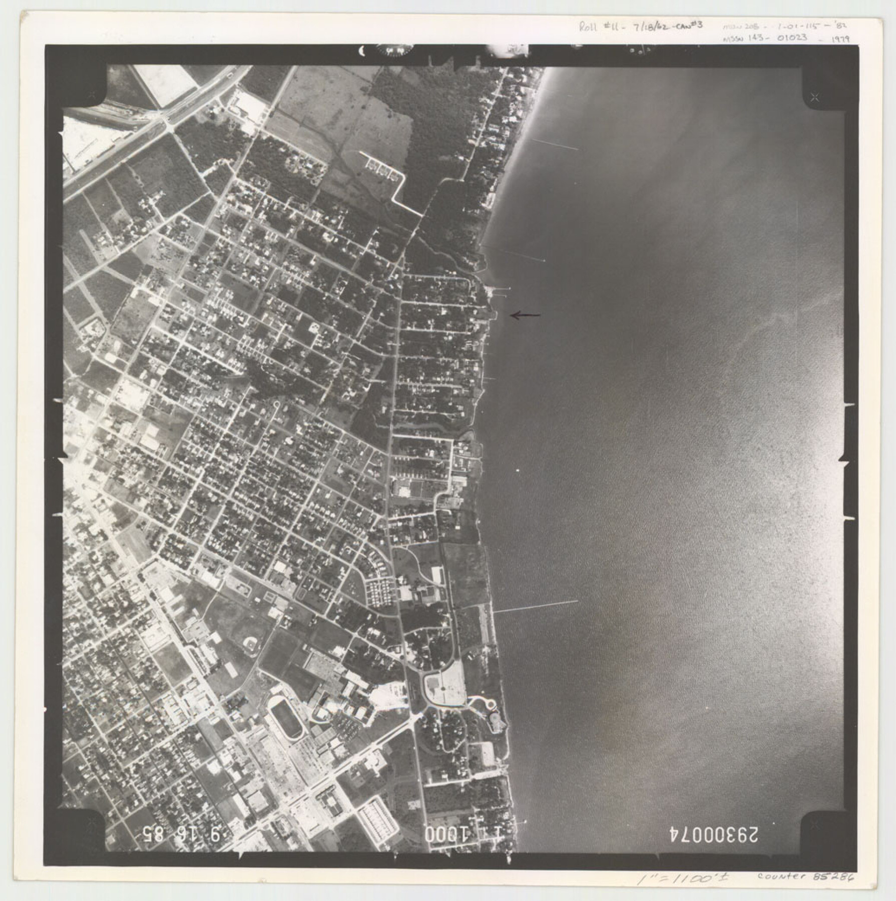
Flight Mission No. 29300074, Harris County
Coastal Maps, Flight Mission No. 29300074, Harris County
-
Map/Doc
85286
-
Collection
General Map Collection
-
Object Dates
1985/9/16 (Creation Date)
-
People and Organizations
U. S. Department of Agriculture (Publisher)
-
Counties
Harris
-
Subjects
Aerial Photograph
-
Height x Width
10.4 x 10.4 inches
26.4 x 26.4 cm
Part of: General Map Collection
Tom Green County Sketch File 80

Print $20.00
- Digital $50.00
Tom Green County Sketch File 80
1962
Size 20.6 x 35.6 inches
Map/Doc 12452
Flight Mission No. BRA-8M, Frame 115, Jefferson County

Print $20.00
- Digital $50.00
Flight Mission No. BRA-8M, Frame 115, Jefferson County
1953
Size 18.6 x 22.2 inches
Map/Doc 85611
Anderson County Working Sketch 12

Print $20.00
- Digital $50.00
Anderson County Working Sketch 12
1914
Size 15.1 x 12.4 inches
Map/Doc 67012
Aransas County Working Sketch 3

Print $20.00
- Digital $50.00
Aransas County Working Sketch 3
1928
Size 20.6 x 32.9 inches
Map/Doc 67170
Right of Way and Track Map, International & Gt. Northern Ry. operated by the International & Gt. Northern Ry. Co. Gulf Division, Mineola Branch

Print $40.00
- Digital $50.00
Right of Way and Track Map, International & Gt. Northern Ry. operated by the International & Gt. Northern Ry. Co. Gulf Division, Mineola Branch
1917
Size 26.3 x 125.4 inches
Map/Doc 64700
Liberty County Sketch File 33

Print $4.00
- Digital $50.00
Liberty County Sketch File 33
Size 10.7 x 7.8 inches
Map/Doc 29967
Martin County Rolled Sketch 9

Print $20.00
- Digital $50.00
Martin County Rolled Sketch 9
1990
Size 17.3 x 11.4 inches
Map/Doc 6669
Tyler County Sketch File A

Print $5.00
- Digital $50.00
Tyler County Sketch File A
1849
Size 9.9 x 15.1 inches
Map/Doc 38603
Map of the City of Kerens (Navarro County) Texas

Print $40.00
- Digital $50.00
Map of the City of Kerens (Navarro County) Texas
1958
Size 44.2 x 54.9 inches
Map/Doc 93670
Carson County Sketch File 3

Print $32.00
- Digital $50.00
Carson County Sketch File 3
1888
Size 5.4 x 8.4 inches
Map/Doc 17335
Presidio County Working Sketch 105

Print $20.00
- Digital $50.00
Presidio County Working Sketch 105
1980
Size 27.5 x 27.5 inches
Map/Doc 71782
Limestone County Working Sketch 17

Print $20.00
- Digital $50.00
Limestone County Working Sketch 17
1959
Size 42.2 x 33.1 inches
Map/Doc 70567
You may also like
McMullen County Working Sketch 6

Print $20.00
- Digital $50.00
McMullen County Working Sketch 6
1926
Size 24.5 x 22.9 inches
Map/Doc 70707
Liberty County Sketch File 38

Print $22.00
- Digital $50.00
Liberty County Sketch File 38
1899
Size 13.9 x 8.9 inches
Map/Doc 29983
Flight Mission No. DIX-8P, Frame 94, Aransas County

Print $20.00
- Digital $50.00
Flight Mission No. DIX-8P, Frame 94, Aransas County
1956
Size 18.5 x 22.3 inches
Map/Doc 83919
Flight Mission No. DAG-17K, Frame 76, Matagorda County

Print $20.00
- Digital $50.00
Flight Mission No. DAG-17K, Frame 76, Matagorda County
1952
Size 16.6 x 16.6 inches
Map/Doc 86335
Fayette County Sketch File 5

Print $4.00
- Digital $50.00
Fayette County Sketch File 5
Size 14.3 x 8.7 inches
Map/Doc 22506
Atascosa County Sketch File 3c

Print $4.00
- Digital $50.00
Atascosa County Sketch File 3c
1858
Size 14.3 x 7.3 inches
Map/Doc 13743
Kleberg County NRC Article 33.136 Sketch 1

Print $143.00
- Digital $50.00
Kleberg County NRC Article 33.136 Sketch 1
2000
Size 18.5 x 23.6 inches
Map/Doc 6555
Dexter Quadrangle

Print $20.00
- Digital $50.00
Dexter Quadrangle
1999
Size 35.4 x 23.4 inches
Map/Doc 97361
Flight Mission No. BQR-4K, Frame 59, Brazoria County

Print $20.00
- Digital $50.00
Flight Mission No. BQR-4K, Frame 59, Brazoria County
1952
Size 18.7 x 22.4 inches
Map/Doc 83992
Boundary Between the United States & Mexico Agreed upon by the Joint Commission under the Treaty of Guadalupe Hidalgo

Print $20.00
- Digital $50.00
Boundary Between the United States & Mexico Agreed upon by the Joint Commission under the Treaty of Guadalupe Hidalgo
1853
Size 18.4 x 26.5 inches
Map/Doc 72884
Nueces County Rolled Sketch 27A

Print $40.00
- Digital $50.00
Nueces County Rolled Sketch 27A
1946
Size 12.4 x 121.3 inches
Map/Doc 9597
Edwards County Rolled Sketch 32

Print $20.00
- Digital $50.00
Edwards County Rolled Sketch 32
1986
Size 36.7 x 24.3 inches
Map/Doc 8850