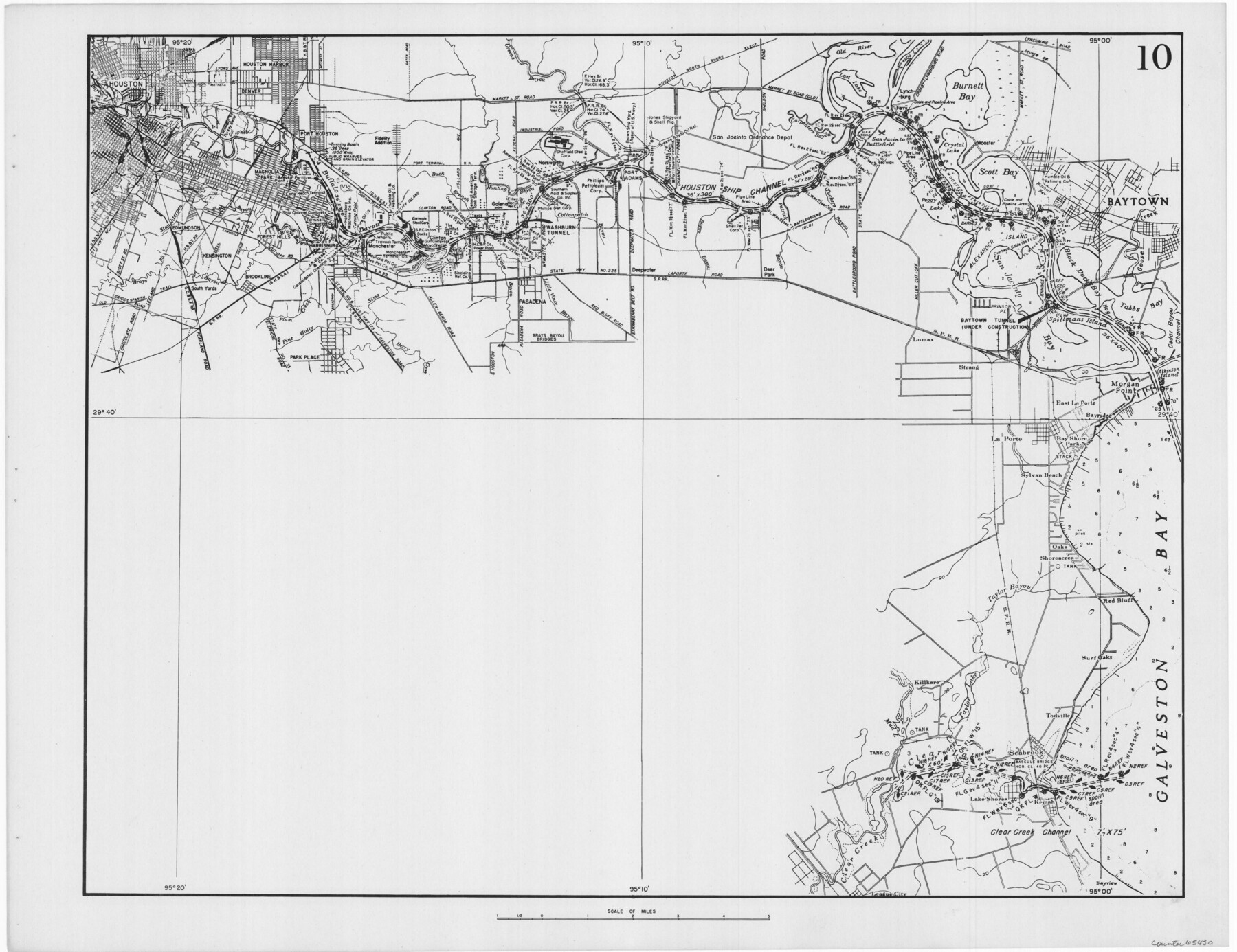
Navigation Maps of Gulf Intracoastal Waterway, Port Arthur to Brownsville, Texas
K-7-68
-
Map/Doc
65430
-
Collection
General Map Collection
-
Object Dates
1951 (Creation Date)
-
People and Organizations
Corps of Engineers (Publisher)
-
Counties
Harris
-
Subjects
Intracoastal Waterways
-
Height x Width
16.6 x 21.5 inches
42.2 x 54.6 cm
Part of: General Map Collection
El Paso County Boundary File 16

Print $6.00
- Digital $50.00
El Paso County Boundary File 16
Size 14.0 x 8.5 inches
Map/Doc 53189
Harris County Texas

Print $20.00
- Digital $50.00
Harris County Texas
1908
Size 19.7 x 24.7 inches
Map/Doc 11652
Mitchell County Sketch File 2

Print $22.00
- Digital $50.00
Mitchell County Sketch File 2
Size 9.1 x 14.0 inches
Map/Doc 31688
Galveston Bay Entrance - Galveston and Texas City Harbors

Print $40.00
- Digital $50.00
Galveston Bay Entrance - Galveston and Texas City Harbors
1975
Size 37.4 x 53.5 inches
Map/Doc 69864
Kinney County Working Sketch 54

Print $20.00
- Digital $50.00
Kinney County Working Sketch 54
1981
Size 40.0 x 32.8 inches
Map/Doc 70236
Bandera County Working Sketch 26

Print $20.00
- Digital $50.00
Bandera County Working Sketch 26
1951
Size 32.3 x 28.4 inches
Map/Doc 67622
Henderson County Working Sketch 16

Print $40.00
- Digital $50.00
Henderson County Working Sketch 16
1937
Size 49.9 x 30.9 inches
Map/Doc 66149
San Patricio County NRC Article 33.136 Sketch 10

Print $692.00
San Patricio County NRC Article 33.136 Sketch 10
2023
Map/Doc 97294
Presidio County Sketch File 28

Print $20.00
- Digital $50.00
Presidio County Sketch File 28
1890
Size 30.2 x 16.1 inches
Map/Doc 11709
Reeves County Boundary File 73a

Print $16.00
- Digital $50.00
Reeves County Boundary File 73a
Size 13.3 x 8.2 inches
Map/Doc 58208
Jeff Davis County Rolled Sketch 11

Print $20.00
- Digital $50.00
Jeff Davis County Rolled Sketch 11
1914
Size 17.9 x 14.4 inches
Map/Doc 6364
Reagan County Rolled Sketch 30

Print $20.00
- Digital $50.00
Reagan County Rolled Sketch 30
Size 32.7 x 28.5 inches
Map/Doc 7446
You may also like
Wilbarger County Working Sketch Graphic Index

Print $20.00
- Digital $50.00
Wilbarger County Working Sketch Graphic Index
1949
Size 46.7 x 38.0 inches
Map/Doc 76740
[SW Corner of Lynn County]
![92903, [SW Corner of Lynn County], Twichell Survey Records](https://historictexasmaps.com/wmedia_w700/maps/92903-1.tif.jpg)
Print $20.00
- Digital $50.00
[SW Corner of Lynn County]
1954
Size 32.2 x 31.1 inches
Map/Doc 92903
Duval County Working Sketch 33

Print $20.00
- Digital $50.00
Duval County Working Sketch 33
1951
Size 21.9 x 23.3 inches
Map/Doc 68757
Brooks County Sketch File 9

Print $2.00
- Digital $50.00
Brooks County Sketch File 9
1988
Size 14.4 x 8.8 inches
Map/Doc 16571
Lampasas County Sketch File 18

Print $4.00
- Digital $50.00
Lampasas County Sketch File 18
Size 8.1 x 4.8 inches
Map/Doc 29430
I. & G. N. - International and Great Northern R.R. - International Route - Galveston, Ft. Worth, Waco, Houston, Austin, Laredo, San Antonio

Print $20.00
- Digital $50.00
I. & G. N. - International and Great Northern R.R. - International Route - Galveston, Ft. Worth, Waco, Houston, Austin, Laredo, San Antonio
1910
Size 24.0 x 16.2 inches
Map/Doc 95779
Cooke County Sketch File 20

Print $22.00
- Digital $50.00
Cooke County Sketch File 20
1862
Size 9.1 x 6.9 inches
Map/Doc 19264
Coryell County Working Sketch 25

Print $20.00
- Digital $50.00
Coryell County Working Sketch 25
1986
Size 22.2 x 29.4 inches
Map/Doc 68232
Cass County Working Sketch 5

Print $20.00
- Digital $50.00
Cass County Working Sketch 5
1936
Size 45.6 x 43.1 inches
Map/Doc 67908
Starr County Rolled Sketch 2

Print $40.00
- Digital $50.00
Starr County Rolled Sketch 2
1853
Size 31.7 x 48.5 inches
Map/Doc 9938
The Chief Justice County of Washington. Undated

Print $20.00
The Chief Justice County of Washington. Undated
2020
Size 13.0 x 21.7 inches
Map/Doc 96077
Right of Way and Track Map Texas & New Orleans R.R. Co. operated by the T. & N. O. R.R. Co. Dallas-Sabine Branch

Print $40.00
- Digital $50.00
Right of Way and Track Map Texas & New Orleans R.R. Co. operated by the T. & N. O. R.R. Co. Dallas-Sabine Branch
1918
Size 25.8 x 56.1 inches
Map/Doc 64155