Reeves County Boundary File 73a
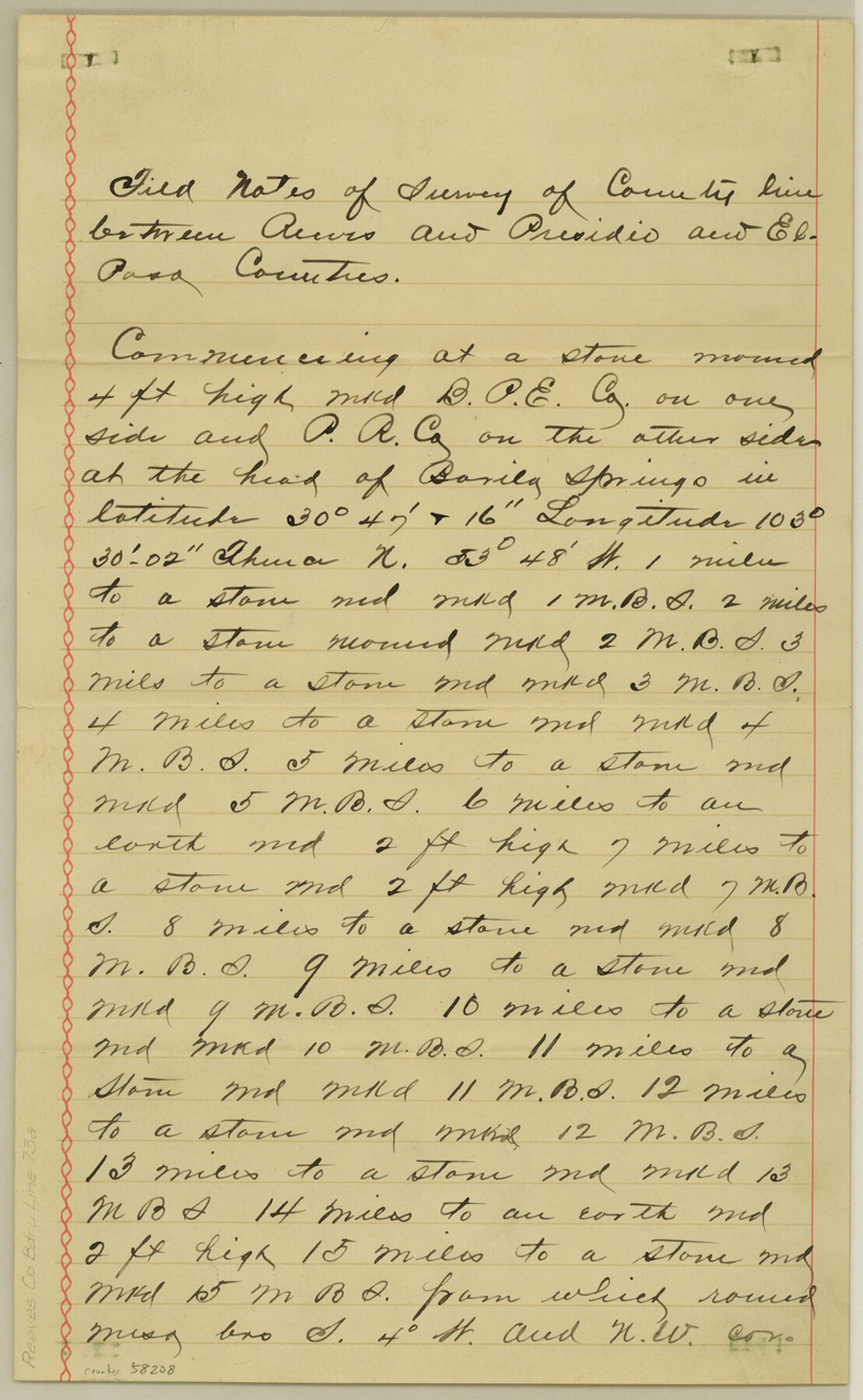
Boundary Line between Reeves and Presidio
-
Map/Doc
58208
-
Collection
General Map Collection
-
Counties
Reeves
-
Subjects
County Boundaries
-
Height x Width
13.3 x 8.2 inches
33.8 x 20.8 cm
Part of: General Map Collection
Ellis County Sketch File 15

Print $40.00
- Digital $50.00
Ellis County Sketch File 15
1861
Size 15.7 x 12.5 inches
Map/Doc 21856
Brewster County Rolled Sketch 134

Print $20.00
- Digital $50.00
Brewster County Rolled Sketch 134
Size 19.0 x 24.9 inches
Map/Doc 5303
McLennan County Sketch File 20

Print $2.00
- Digital $50.00
McLennan County Sketch File 20
Size 8.0 x 9.1 inches
Map/Doc 31293
Flight Mission No. CRC-4R, Frame 70, Chambers County

Print $20.00
- Digital $50.00
Flight Mission No. CRC-4R, Frame 70, Chambers County
1956
Size 18.7 x 22.4 inches
Map/Doc 84874
A New Map of Texas

Print $20.00
- Digital $50.00
A New Map of Texas
1841
Size 18.2 x 17.2 inches
Map/Doc 96636
Mitchell County Rolled Sketch 3

Print $40.00
- Digital $50.00
Mitchell County Rolled Sketch 3
1940
Size 39.6 x 49.0 inches
Map/Doc 9524
Uvalde County Working Sketch 29

Print $20.00
- Digital $50.00
Uvalde County Working Sketch 29
1958
Size 25.3 x 41.0 inches
Map/Doc 72099
Dickens County Rolled Sketch C & C1

Print $35.00
- Digital $50.00
Dickens County Rolled Sketch C & C1
1895
Size 10.6 x 15.5 inches
Map/Doc 44297
Duval County Rolled Sketch 11

Print $20.00
- Digital $50.00
Duval County Rolled Sketch 11
Size 20.4 x 30.1 inches
Map/Doc 5733
Clay County Boundary File 5

Print $6.00
- Digital $50.00
Clay County Boundary File 5
Size 11.1 x 8.5 inches
Map/Doc 51373
Orange County - West one half of Sabine River showing leases 5 & 6 traced from U. S. C. & G. S. chart no. 533

Print $20.00
- Digital $50.00
Orange County - West one half of Sabine River showing leases 5 & 6 traced from U. S. C. & G. S. chart no. 533
1957
Size 30.6 x 35.4 inches
Map/Doc 2899
Hamilton County Working Sketch 11

Print $20.00
- Digital $50.00
Hamilton County Working Sketch 11
1949
Size 45.1 x 43.7 inches
Map/Doc 63349
You may also like
Map of Tom Green County

Print $40.00
- Digital $50.00
Map of Tom Green County
1892
Size 42.9 x 48.2 inches
Map/Doc 63069
General Highway Map. Detail of Cities and Towns in Travis County, Texas. City Map, Austin and vicinity, Travis County, Texas

Print $20.00
General Highway Map. Detail of Cities and Towns in Travis County, Texas. City Map, Austin and vicinity, Travis County, Texas
1961
Size 18.1 x 24.7 inches
Map/Doc 79687

Cameron County Rolled Sketch 16

Print $20.00
- Digital $50.00
Cameron County Rolled Sketch 16
Size 31.8 x 37.4 inches
Map/Doc 8569
[Movements & Objectives of the 143rd & 144th Infantry on October 12-13, 1918] - Verso
![94136, [Movements & Objectives of the 143rd & 144th Infantry on October 12-13, 1918] - Verso, Non-GLO Digital Images](https://historictexasmaps.com/wmedia_w700/maps/94136-1.tif.jpg)
Print $20.00
[Movements & Objectives of the 143rd & 144th Infantry on October 12-13, 1918] - Verso
1918
Size 42.4 x 30.0 inches
Map/Doc 94136
Knox County Working Sketch 15

Print $20.00
- Digital $50.00
Knox County Working Sketch 15
1958
Size 29.5 x 32.4 inches
Map/Doc 70257
Brewster County Rolled Sketch 71

Print $20.00
- Digital $50.00
Brewster County Rolled Sketch 71
1940
Size 29.9 x 42.9 inches
Map/Doc 8491
Sabine County Working Sketch 6

Print $20.00
- Digital $50.00
Sabine County Working Sketch 6
1918
Size 17.5 x 17.6 inches
Map/Doc 63677
Montgomery County Working Sketch 4

Print $20.00
- Digital $50.00
Montgomery County Working Sketch 4
1926
Size 20.9 x 22.2 inches
Map/Doc 71110
Right of Way and Track Map, the Missouri, Kansas and Texas Ry. of Texas operated by the Missouri, Kansas and Texas Ry. of Texas, San Antonio Division

Print $40.00
- Digital $50.00
Right of Way and Track Map, the Missouri, Kansas and Texas Ry. of Texas operated by the Missouri, Kansas and Texas Ry. of Texas, San Antonio Division
1918
Size 25.6 x 58.7 inches
Map/Doc 64581
Jeff Davis County Sketch File 17

Print $6.00
- Digital $50.00
Jeff Davis County Sketch File 17
1884
Size 8.8 x 7.3 inches
Map/Doc 27948
Kimble County Working Sketch 76

Print $20.00
- Digital $50.00
Kimble County Working Sketch 76
1969
Size 27.7 x 41.0 inches
Map/Doc 70144