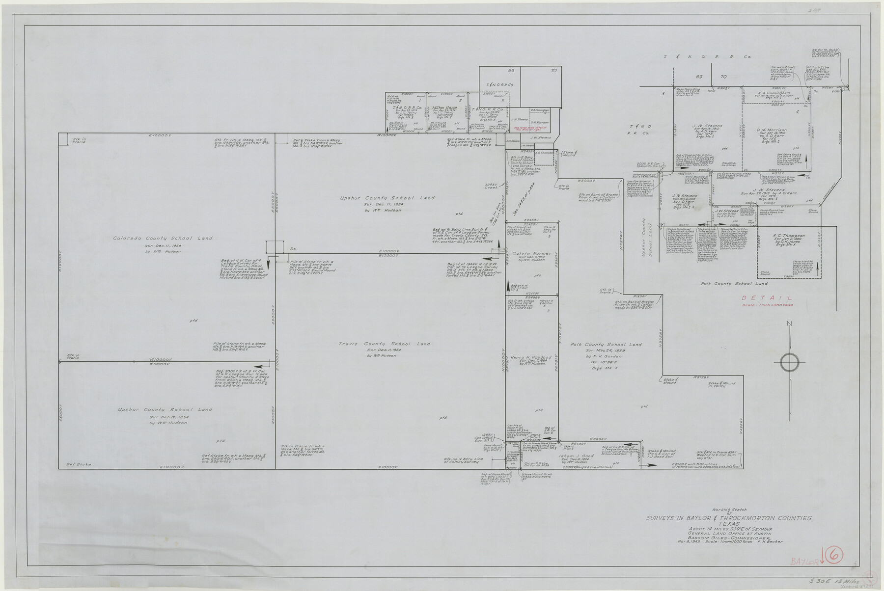
Baylor County Working Sketch 6
-
Map/Doc
67291
-
Collection
General Map Collection
-
Object Dates
11/8/1943 (Creation Date)
-
People and Organizations
Bascom Giles (GLO Commissioner)
F.H. Becker (Draftsman)
-
Counties
Baylor Throckmorton
-
Subjects
Surveying Working Sketch
-
Height x Width
27.5 x 41.0 inches
69.9 x 104.1 cm
-
Scale
1" = 1000 varas
-
Comments
Surveys located about 13 miles South 30 degrees East of Seymour, Texas.
Part of: General Map Collection
Segunda parte del Mapa, que comprende la Frontera, de los Dominios del Rey, en la America Septentrional

Print $40.00
- Digital $50.00
Segunda parte del Mapa, que comprende la Frontera, de los Dominios del Rey, en la America Septentrional
1769
Size 26.7 x 63.8 inches
Map/Doc 4667
Fort Bend County Rolled Sketch A

Print $20.00
- Digital $50.00
Fort Bend County Rolled Sketch A
1900
Size 19.8 x 29.7 inches
Map/Doc 5903
Flight Mission No. DQO-7K, Frame 106, Galveston County

Print $20.00
- Digital $50.00
Flight Mission No. DQO-7K, Frame 106, Galveston County
1952
Size 18.5 x 22.6 inches
Map/Doc 85121
Morris County Rolled Sketch 2A

Print $20.00
- Digital $50.00
Morris County Rolled Sketch 2A
Size 24.1 x 18.9 inches
Map/Doc 10261
Smith County Rolled Sketch 6D2

Print $2.00
- Digital $50.00
Smith County Rolled Sketch 6D2
Size 11.3 x 8.9 inches
Map/Doc 76014
Nueces County Sketch File 70

Print $8.00
- Digital $50.00
Nueces County Sketch File 70
Size 11.2 x 8.6 inches
Map/Doc 33007
Webb County Working Sketch 3

Print $20.00
- Digital $50.00
Webb County Working Sketch 3
1906
Size 18.2 x 27.2 inches
Map/Doc 72368
San Jacinto County Rolled Sketch 5

Print $20.00
- Digital $50.00
San Jacinto County Rolled Sketch 5
Size 13.7 x 18.6 inches
Map/Doc 8386
[Field book of Martin Duval, Wilbarger Co., H&TC RR Co. Blocks 13 & 14]
![61431, [Field book of Martin Duval, Wilbarger Co., H&TC RR Co. Blocks 13 & 14], General Map Collection](https://historictexasmaps.com/wmedia_w700/pdf_converted_jpg/qi_pdf_thumbnail_17161.jpg)
[Field book of Martin Duval, Wilbarger Co., H&TC RR Co. Blocks 13 & 14]
Size 6.7 x 8.2 inches
Map/Doc 61431
[Surveys in Polk County]
![69751, [Surveys in Polk County], General Map Collection](https://historictexasmaps.com/wmedia_w700/maps/69751.tif.jpg)
Print $2.00
- Digital $50.00
[Surveys in Polk County]
1847
Size 4.6 x 6.6 inches
Map/Doc 69751
Flight Mission No. BQR-14K, Frame 38, Brazoria County

Print $20.00
- Digital $50.00
Flight Mission No. BQR-14K, Frame 38, Brazoria County
1952
Size 18.8 x 22.3 inches
Map/Doc 84095
Coryell County Sketch File 13

Print $4.00
- Digital $50.00
Coryell County Sketch File 13
1872
Size 5.0 x 8.5 inches
Map/Doc 19366
You may also like
Ochiltree County Working Sketch 6

Print $20.00
- Digital $50.00
Ochiltree County Working Sketch 6
1962
Size 31.1 x 22.9 inches
Map/Doc 71319
University Land Field Notes for Block L in El Paso County

University Land Field Notes for Block L in El Paso County
Map/Doc 81725
Titus County Working Sketch 7

Print $20.00
- Digital $50.00
Titus County Working Sketch 7
1970
Size 31.5 x 28.7 inches
Map/Doc 69368
Pecos County Working Sketch 118

Print $20.00
- Digital $50.00
Pecos County Working Sketch 118
1973
Size 46.2 x 36.9 inches
Map/Doc 71591
Morris County Rolled Sketch 2A

Print $20.00
- Digital $50.00
Morris County Rolled Sketch 2A
Size 24.0 x 18.7 inches
Map/Doc 10277
Briscoe County Rolled Sketch 20

Print $20.00
- Digital $50.00
Briscoe County Rolled Sketch 20
1949
Size 37.4 x 21.7 inches
Map/Doc 5334
Newton County Sketch File 19

Print $20.00
- Digital $50.00
Newton County Sketch File 19
Size 22.8 x 9.4 inches
Map/Doc 42158
Tarrant County Working Sketch 14

Print $20.00
- Digital $50.00
Tarrant County Working Sketch 14
1989
Size 26.5 x 31.0 inches
Map/Doc 62431
Wharton County Sketch File 15

Print $20.00
- Digital $50.00
Wharton County Sketch File 15
Size 18.2 x 21.1 inches
Map/Doc 12665
National Parks, Monuments and Shrines of the United States and Canada

National Parks, Monuments and Shrines of the United States and Canada
1958
Size 25.5 x 19.5 inches
Map/Doc 92378
Map of Colorado County

Print $20.00
- Digital $50.00
Map of Colorado County
1864
Size 22.1 x 25.0 inches
Map/Doc 3423
Ward County, Texas

Print $20.00
- Digital $50.00
Ward County, Texas
1888
Size 20.2 x 25.5 inches
Map/Doc 657