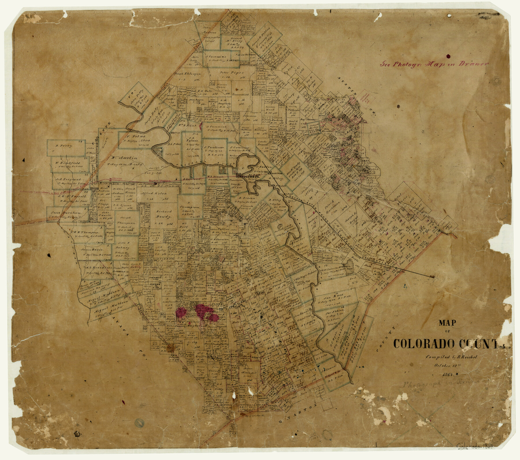
Map of Colorado County
-
Map/Doc
3423
-
Collection
General Map Collection
-
Object Dates
10/12/1864 (Creation Date)
-
People and Organizations
Robert Reichel (Compiler)
-
Counties
Colorado
-
Subjects
County
-
Height x Width
22.1 x 25.0 inches
56.1 x 63.5 cm
-
Features
Waterhole Creek
Gonzales Road
Prairie Creek
Miller's Creek
Live Oak Creek
San Bernard River
Eagle Lake
Skull Creek
Crascoe's Creek
GH&SA
Navidad River
Honey Creek
South Sandies Creek
Sandies Creek
Clear Fork of South Sandies Creek
North Sandies Creek
Mustang Creek
Cummins Creek
Weimar
Borden Station
Columbus
Alleyton
Wolfpen Creek
BBB&C
Stuart's Creek
Pine Creek
Colorado River
Marvey's Creek
Brush Creek
Crier Creek
Rocky Creek
Redgates Creek
Mill Creek
Part of: General Map Collection
Bowie County Working Sketch 10b

Print $20.00
- Digital $50.00
Bowie County Working Sketch 10b
1956
Size 31.1 x 37.6 inches
Map/Doc 67414
Chambers County Sketch File 57

Print $13.00
- Digital $50.00
Chambers County Sketch File 57
1935
Size 14.7 x 8.9 inches
Map/Doc 18102
Ward County Working Sketch 47

Print $20.00
- Digital $50.00
Ward County Working Sketch 47
1974
Size 41.3 x 33.9 inches
Map/Doc 72353
Sterling County Sketch File 17x

Print $4.00
- Digital $50.00
Sterling County Sketch File 17x
Size 9.0 x 13.7 inches
Map/Doc 37165
Lynn County Rolled Sketch W

Print $20.00
- Digital $50.00
Lynn County Rolled Sketch W
Size 23.0 x 40.0 inches
Map/Doc 6655
Carson County Boundary File 8a

Print $40.00
- Digital $50.00
Carson County Boundary File 8a
Size 12.5 x 34.7 inches
Map/Doc 51173
Flight Mission No. DIX-6P, Frame 109, Aransas County

Print $20.00
- Digital $50.00
Flight Mission No. DIX-6P, Frame 109, Aransas County
1956
Size 18.8 x 22.5 inches
Map/Doc 83815
Flight Mission No. CUG-3P, Frame 12, Kleberg County

Print $20.00
- Digital $50.00
Flight Mission No. CUG-3P, Frame 12, Kleberg County
1956
Size 18.5 x 22.3 inches
Map/Doc 86222
Anderson County Working Sketch 42

Print $40.00
- Digital $50.00
Anderson County Working Sketch 42
1987
Size 34.4 x 51.1 inches
Map/Doc 67042
Randall County Rolled Sketch 10

Print $20.00
- Digital $50.00
Randall County Rolled Sketch 10
Size 26.9 x 22.6 inches
Map/Doc 7431
Hunt County Sketch File 16a

Print $4.00
- Digital $50.00
Hunt County Sketch File 16a
Size 4.6 x 8.1 inches
Map/Doc 27109
Callahan County Sketch File 6a

Print $24.00
- Digital $50.00
Callahan County Sketch File 6a
Size 8.0 x 6.8 inches
Map/Doc 35860
You may also like
Cottle County Working Sketch 16

Print $20.00
- Digital $50.00
Cottle County Working Sketch 16
1975
Size 24.5 x 21.6 inches
Map/Doc 68326
Galveston Bay and Approaches

Print $20.00
- Digital $50.00
Galveston Bay and Approaches
1957
Size 43.6 x 32.7 inches
Map/Doc 69877
Presidio County Rolled Sketch 4

Print $40.00
- Digital $50.00
Presidio County Rolled Sketch 4
Size 19.1 x 69.8 inches
Map/Doc 10733
Map of the United States showing the Texas & Pacific Railway and its connections

Print $20.00
- Digital $50.00
Map of the United States showing the Texas & Pacific Railway and its connections
1875
Size 11.9 x 16.8 inches
Map/Doc 93960
Flight Mission No. CRC-4R, Frame 103, Chambers County

Print $20.00
- Digital $50.00
Flight Mission No. CRC-4R, Frame 103, Chambers County
1956
Size 18.4 x 22.3 inches
Map/Doc 84900
Polk County Texas

Print $20.00
- Digital $50.00
Polk County Texas
1897
Size 27.1 x 21.0 inches
Map/Doc 3956
Pecos County Rolled Sketch 32A

Print $7.00
- Digital $50.00
Pecos County Rolled Sketch 32A
1890
Size 10.5 x 15.2 inches
Map/Doc 48096
Map of Defunct and Ghost Counties in Texas

Print $20.00
- Digital $50.00
Map of Defunct and Ghost Counties in Texas
1939
Size 35.0 x 35.9 inches
Map/Doc 2148
[Sketch showing voting precincts in Jim Hogg and Brooks Counties]
![4497, [Sketch showing voting precincts in Jim Hogg and Brooks Counties], Maddox Collection](https://historictexasmaps.com/wmedia_w700/maps/4497-1.tif.jpg)
Print $20.00
- Digital $50.00
[Sketch showing voting precincts in Jim Hogg and Brooks Counties]
Size 10.1 x 18.2 inches
Map/Doc 4497
Flight Mission No. DAG-24K, Frame 132, Matagorda County

Print $20.00
- Digital $50.00
Flight Mission No. DAG-24K, Frame 132, Matagorda County
1953
Size 15.8 x 15.8 inches
Map/Doc 86550
Map of the Fort Worth & Denver City Railway, Wichita County, Texas

Print $40.00
- Digital $50.00
Map of the Fort Worth & Denver City Railway, Wichita County, Texas
1885
Size 25.2 x 122.4 inches
Map/Doc 64454
Williamson County Sketch File 17

Print $8.00
- Digital $50.00
Williamson County Sketch File 17
1876
Size 6.5 x 8.1 inches
Map/Doc 40338