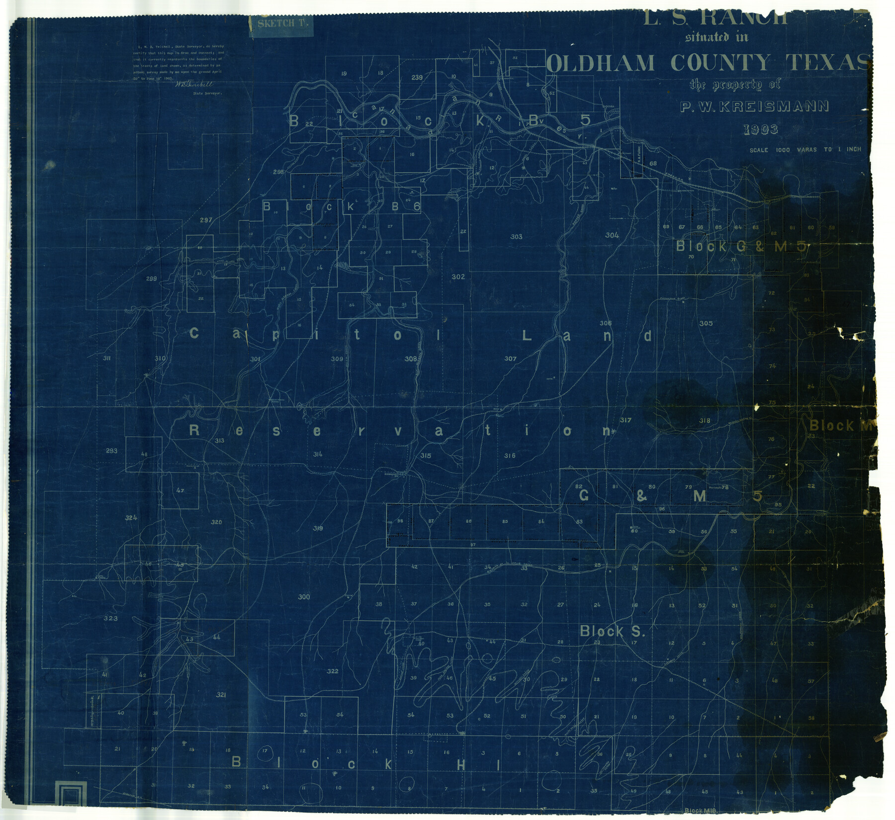
Oldham County Rolled Sketch T
L.S. Ranch situated in Oldham County, Texas - the property of P.W. Kreismann
-
Map/Doc
9642
-
Collection
General Map Collection
-
Object Dates
1903/6/18 (Creation Date)
-
People and Organizations
W.D. Twichell (Surveyor/Engineer)
-
Counties
Oldham
-
Subjects
Surveying Rolled Sketch
-
Height x Width
42.3 x 46.2 inches
107.4 x 117.3 cm
-
Medium
blueprint/diazo
-
Scale
1" = 1000 varas
Part of: General Map Collection
Texas, Matagorda Bay, Matagorda Peninsula, Cany Creek to Tiger Island Channel

Print $40.00
- Digital $50.00
Texas, Matagorda Bay, Matagorda Peninsula, Cany Creek to Tiger Island Channel
1933
Size 31.4 x 48.6 inches
Map/Doc 69991

Crockett County Working Sketch 16

Print $20.00
- Digital $50.00
Crockett County Working Sketch 16
1917
Size 24.0 x 29.0 inches
Map/Doc 68349
Webb County Rolled Sketch 38

Print $20.00
- Digital $50.00
Webb County Rolled Sketch 38
1940
Size 22.2 x 16.0 inches
Map/Doc 8193
Montgomery County Working Sketch 58

Print $40.00
- Digital $50.00
Montgomery County Working Sketch 58
1962
Size 39.1 x 51.0 inches
Map/Doc 71165
[Surveys in Austin's Colony along the east bank of the Navidad River]
![211, [Surveys in Austin's Colony along the east bank of the Navidad River], General Map Collection](https://historictexasmaps.com/wmedia_w700/maps/211.tif.jpg)
Print $20.00
- Digital $50.00
[Surveys in Austin's Colony along the east bank of the Navidad River]
1827
Size 20.2 x 16.1 inches
Map/Doc 211
Map of Portion of the Gulf of Mexico Adjoining Jefferson County Showing Subdivision Thereof for Mineral Development

Print $20.00
- Digital $50.00
Map of Portion of the Gulf of Mexico Adjoining Jefferson County Showing Subdivision Thereof for Mineral Development
1937
Size 20.5 x 39.0 inches
Map/Doc 3020
Coleman County Working Sketch 19

Print $20.00
- Digital $50.00
Coleman County Working Sketch 19
1953
Size 18.1 x 15.4 inches
Map/Doc 68085
Zavala County Sketch File 9

Print $20.00
- Digital $50.00
Zavala County Sketch File 9
1884
Size 29.1 x 15.9 inches
Map/Doc 12727
Flight Mission No. DCL-7C, Frame 146, Kenedy County

Print $20.00
- Digital $50.00
Flight Mission No. DCL-7C, Frame 146, Kenedy County
1943
Size 18.8 x 22.4 inches
Map/Doc 86103
Grayson County Working Sketch 22

Print $20.00
- Digital $50.00
Grayson County Working Sketch 22
1962
Size 21.5 x 33.6 inches
Map/Doc 63261
Live Oak County Sketch File 15

Print $4.00
- Digital $50.00
Live Oak County Sketch File 15
Size 12.6 x 8.1 inches
Map/Doc 30280
You may also like
Flight Mission No. BQY-4M, Frame 53, Harris County

Print $20.00
- Digital $50.00
Flight Mission No. BQY-4M, Frame 53, Harris County
1953
Size 18.6 x 22.3 inches
Map/Doc 85262
Gray County Sketch File 6

Print $20.00
- Digital $50.00
Gray County Sketch File 6
1882
Size 26.3 x 21.4 inches
Map/Doc 11575
Lampasas County Boundary File 4

Print $44.00
- Digital $50.00
Lampasas County Boundary File 4
Size 14.0 x 8.5 inches
Map/Doc 56110
Liberty County Sketch File 54

Print $54.00
- Digital $50.00
Liberty County Sketch File 54
1889
Size 14.3 x 8.7 inches
Map/Doc 30022

Young County Working Sketch 2

Print $20.00
- Digital $50.00
Young County Working Sketch 2
1918
Size 28.1 x 33.7 inches
Map/Doc 62025
Stephens County Working Sketch 38

Print $20.00
- Digital $50.00
Stephens County Working Sketch 38
1988
Size 24.3 x 32.7 inches
Map/Doc 63981
Lynn County Sketch File 19

Print $36.00
- Digital $50.00
Lynn County Sketch File 19
Size 11.2 x 8.7 inches
Map/Doc 30519
Garza County Plat

Print $20.00
- Digital $50.00
Garza County Plat
1948
Size 21.1 x 17.7 inches
Map/Doc 92703
Flight Mission No. BRA-8M, Frame 114, Jefferson County

Print $20.00
- Digital $50.00
Flight Mission No. BRA-8M, Frame 114, Jefferson County
1953
Size 18.6 x 22.2 inches
Map/Doc 85610
Flight Mission No. BRA-6M, Frame 79, Jefferson County

Print $20.00
- Digital $50.00
Flight Mission No. BRA-6M, Frame 79, Jefferson County
1953
Size 18.6 x 22.4 inches
Map/Doc 85423
[Block C-41, Sections 32, 35, 35 1/2, and vicinity]
![92570, [Block C-41, Sections 32, 35, 35 1/2, and vicinity], Twichell Survey Records](https://historictexasmaps.com/wmedia_w700/maps/92570-1.tif.jpg)
Print $20.00
- Digital $50.00
[Block C-41, Sections 32, 35, 35 1/2, and vicinity]
Size 23.9 x 19.4 inches
Map/Doc 92570