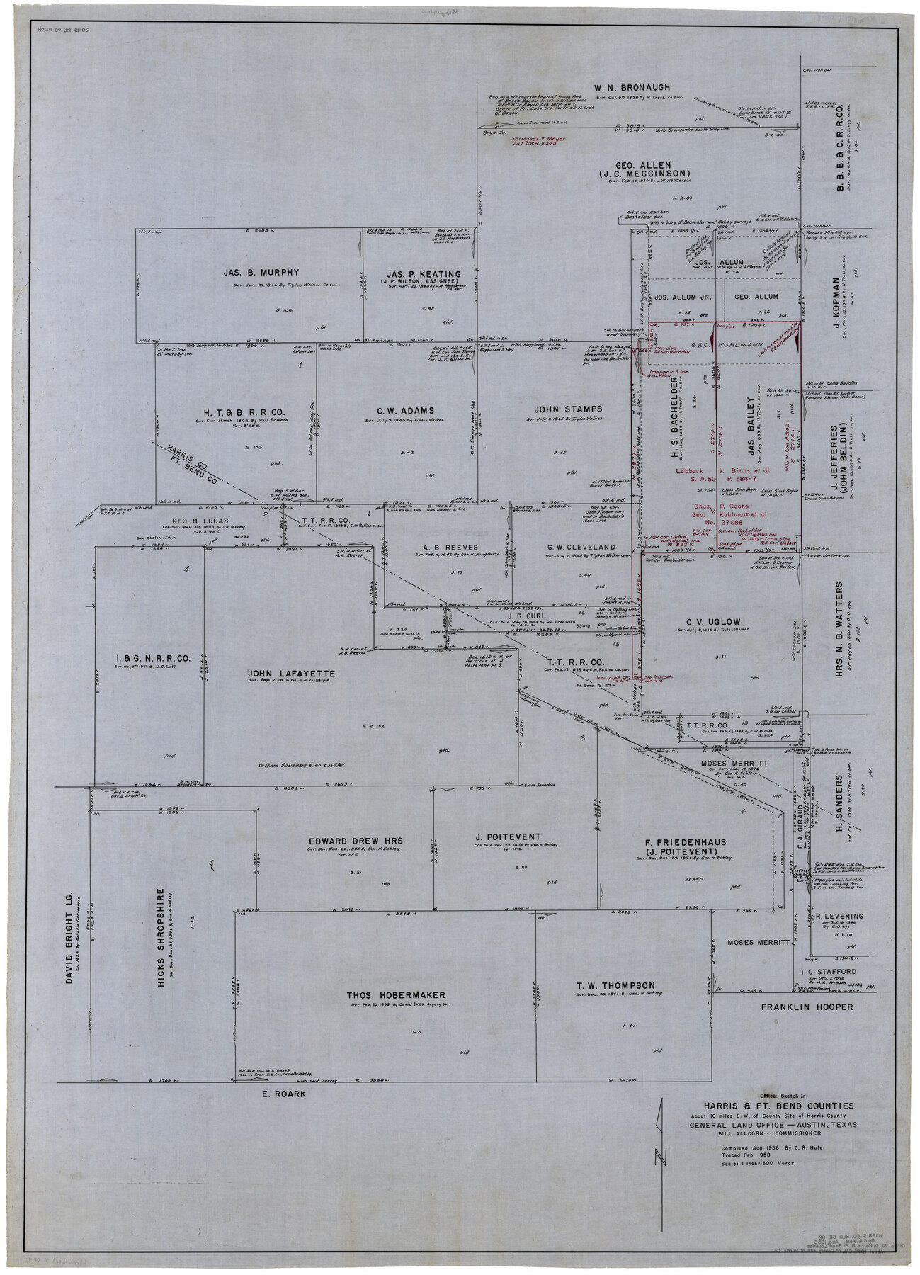
Harris County Rolled Sketch 82
Office Sketch in Harris & Ft. Bend Counties
-
Map/Doc
9138
-
Collection
General Map Collection
-
Object Dates
8/1956 (Creation Date)
2/1958 (Copy/Tracing Date)
-
People and Organizations
C.R. Hale (Compiler)
-
Counties
Harris Fort Bend
-
Subjects
Surveying Rolled Sketch
-
Height x Width
50.5 x 36.4 inches
128.3 x 92.5 cm
-
Medium
linen, manuscript
-
Scale
1" = 300 varas
Part of: General Map Collection
Bowie County Sketch File 7b

Print $10.00
- Digital $50.00
Bowie County Sketch File 7b
1927
Size 10.7 x 8.6 inches
Map/Doc 14859
Gulf, Texas & Western Railway

Print $40.00
- Digital $50.00
Gulf, Texas & Western Railway
1909
Size 18.7 x 103.5 inches
Map/Doc 64431
Montague County Working Sketch 28

Print $20.00
- Digital $50.00
Montague County Working Sketch 28
1963
Size 36.6 x 31.8 inches
Map/Doc 71094
Starr County Rolled Sketch 39

Print $20.00
- Digital $50.00
Starr County Rolled Sketch 39
1954
Size 24.9 x 27.7 inches
Map/Doc 7833
Flight Mission No. BQR-4K, Frame 58, Brazoria County

Print $20.00
- Digital $50.00
Flight Mission No. BQR-4K, Frame 58, Brazoria County
1952
Size 18.7 x 22.4 inches
Map/Doc 83991
Van Zandt County Working Sketch 9

Print $20.00
- Digital $50.00
Van Zandt County Working Sketch 9
1982
Size 12.6 x 11.7 inches
Map/Doc 72259
Map of Nacogdoches County

Print $20.00
- Digital $50.00
Map of Nacogdoches County
1857
Size 22.9 x 24.3 inches
Map/Doc 3907
PSF Field Notes for Blocks 42 1/2 and 43 in Culberson and Hudspeth Counties, and Blocks 30 through 41 in Hudspeth County

PSF Field Notes for Blocks 42 1/2 and 43 in Culberson and Hudspeth Counties, and Blocks 30 through 41 in Hudspeth County
Map/Doc 81660
Newton County Rolled Sketch 15

Print $20.00
- Digital $50.00
Newton County Rolled Sketch 15
1953
Size 26.0 x 43.7 inches
Map/Doc 6845
Presidio County Rolled Sketch 35

Print $20.00
- Digital $50.00
Presidio County Rolled Sketch 35
Size 44.7 x 32.1 inches
Map/Doc 9774

Blanco County Sketch File 28

Print $40.00
- Digital $50.00
Blanco County Sketch File 28
1888
Size 13.8 x 13.2 inches
Map/Doc 14623
You may also like
Matagorda County Working Sketch 11

Print $20.00
- Digital $50.00
Matagorda County Working Sketch 11
1957
Size 34.6 x 43.6 inches
Map/Doc 70869
[Wilson Strickland Survey]
![91378, [Wilson Strickland Survey], Twichell Survey Records](https://historictexasmaps.com/wmedia_w700/maps/91378-1.tif.jpg)
Print $20.00
- Digital $50.00
[Wilson Strickland Survey]
Size 39.7 x 29.2 inches
Map/Doc 91378
Sketch in Martin County Showing Survey 13, Block X

Print $2.00
- Digital $50.00
Sketch in Martin County Showing Survey 13, Block X
1908
Size 12.6 x 8.4 inches
Map/Doc 91286
Reeves County Working Sketch 43

Print $20.00
- Digital $50.00
Reeves County Working Sketch 43
1974
Size 43.2 x 37.1 inches
Map/Doc 63486
Wise County Sketch File 14

Print $24.00
- Digital $50.00
Wise County Sketch File 14
1855
Size 12.8 x 8.2 inches
Map/Doc 40548

Ector County Boundary File 1

Print $10.00
- Digital $50.00
Ector County Boundary File 1
Size 13.3 x 8.4 inches
Map/Doc 52829
Crockett County Rolled Sketch 50

Print $20.00
- Digital $50.00
Crockett County Rolled Sketch 50
1940
Size 31.5 x 40.7 inches
Map/Doc 8714
San Luis Pass to East Matagorda Bay

Print $20.00
- Digital $50.00
San Luis Pass to East Matagorda Bay
1957
Size 34.9 x 46.9 inches
Map/Doc 69962
Lamar County Working Sketch 4

Print $20.00
- Digital $50.00
Lamar County Working Sketch 4
1920
Size 14.4 x 25.1 inches
Map/Doc 70265
San Luis Pass to East Matagorda Bay

Print $40.00
- Digital $50.00
San Luis Pass to East Matagorda Bay
1986
Size 35.6 x 49.0 inches
Map/Doc 69971
Map of Northern Boundary Line of Texas and Pacific 80 Mile Reservation

Print $20.00
- Digital $50.00
Map of Northern Boundary Line of Texas and Pacific 80 Mile Reservation
1902
Size 16.8 x 16.7 inches
Map/Doc 65694