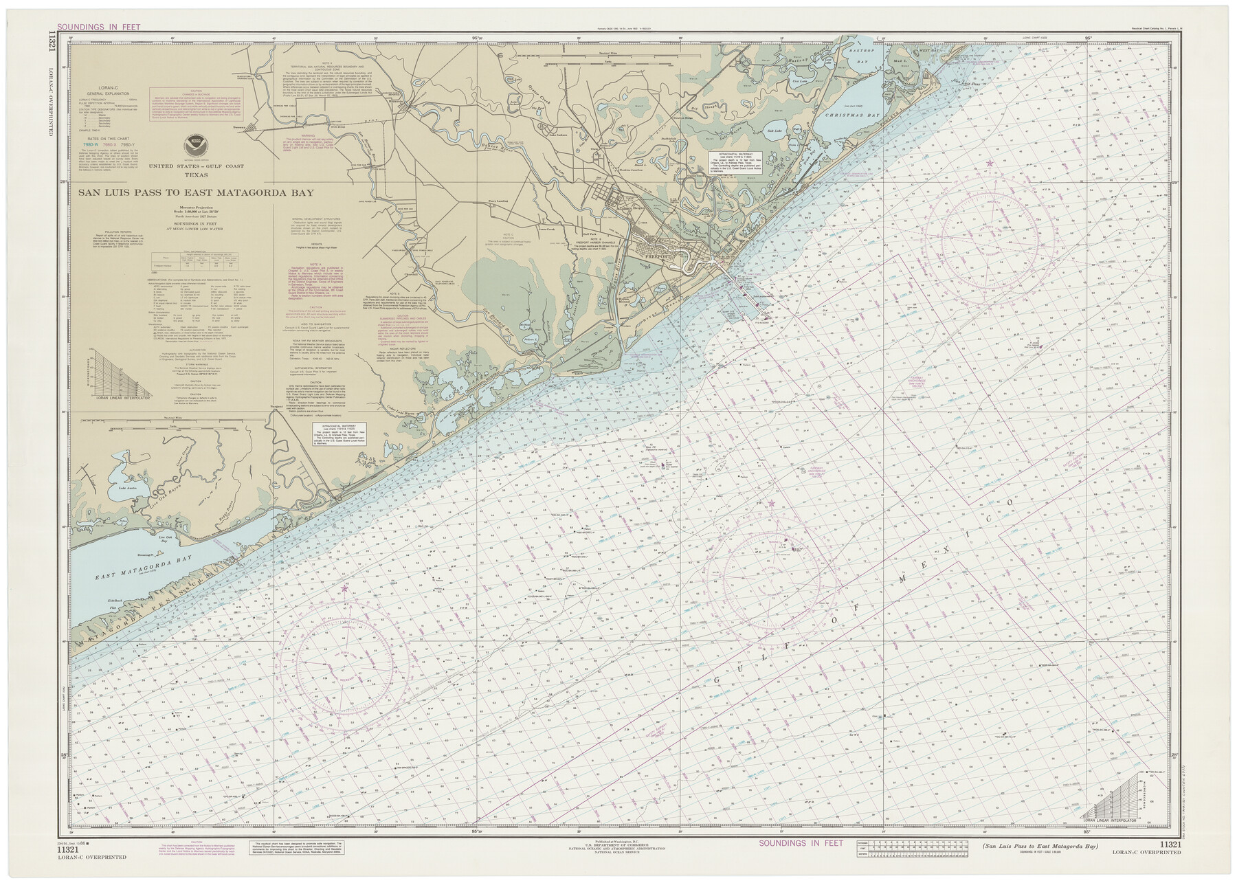
San Luis Pass to East Matagorda Bay
K-6-1283d
-
Map/Doc
69971
-
Collection
General Map Collection
-
Object Dates
9/13/1986 (Creation Date)
-
Counties
Galveston Matagorda Brazoria
-
Subjects
Nautical Charts
-
Height x Width
35.6 x 49.0 inches
90.4 x 124.5 cm
Part of: General Map Collection
Topographical Map of the Rio Grande from Roma to the Gulf of Mexico, Index Map, Sheet No. 1

Print $20.00
- Digital $50.00
Topographical Map of the Rio Grande from Roma to the Gulf of Mexico, Index Map, Sheet No. 1
1912
Map/Doc 89523
Maverick County Rolled Sketch 14A

Print $20.00
- Digital $50.00
Maverick County Rolled Sketch 14A
Size 35.4 x 18.2 inches
Map/Doc 6708
San Patricio County Sketch File 45

Print $20.00
- Digital $50.00
San Patricio County Sketch File 45
1943
Size 11.2 x 8.9 inches
Map/Doc 36273
Brooks County Rolled Sketch 16

Print $20.00
- Digital $50.00
Brooks County Rolled Sketch 16
1941
Size 18.0 x 18.8 inches
Map/Doc 5341
Montgomery County Working Sketch 57

Print $20.00
- Digital $50.00
Montgomery County Working Sketch 57
1961
Size 24.2 x 26.6 inches
Map/Doc 71164
McMullen County Working Sketch 55

Print $20.00
- Digital $50.00
McMullen County Working Sketch 55
1983
Size 15.2 x 19.2 inches
Map/Doc 70756
Edwards County

Print $20.00
- Digital $50.00
Edwards County
1893
Size 26.7 x 30.2 inches
Map/Doc 4650

Hutchinson County Boundary File 3

Print $4.00
- Digital $50.00
Hutchinson County Boundary File 3
Size 11.3 x 8.9 inches
Map/Doc 55303
Flight Mission No. DQN-7K, Frame 92, Calhoun County

Print $20.00
- Digital $50.00
Flight Mission No. DQN-7K, Frame 92, Calhoun County
1953
Size 17.2 x 19.1 inches
Map/Doc 84483
Hays County Working Sketch 3

Print $20.00
- Digital $50.00
Hays County Working Sketch 3
1925
Size 28.2 x 24.1 inches
Map/Doc 66077
Hudspeth County Working Sketch 40

Print $20.00
- Digital $50.00
Hudspeth County Working Sketch 40
1981
Size 35.6 x 43.8 inches
Map/Doc 66325
You may also like
[Block 28, Showing Edwards Ranch]
![91499, [Block 28, Showing Edwards Ranch], Twichell Survey Records](https://historictexasmaps.com/wmedia_w700/maps/91499-1.tif.jpg)
Print $3.00
- Digital $50.00
[Block 28, Showing Edwards Ranch]
Size 17.0 x 8.9 inches
Map/Doc 91499
[Affadavit regarding boundary lines between the several coastal counties from coastline to Continental Shelf]
![2089, [Affadavit regarding boundary lines between the several coastal counties from coastline to Continental Shelf], General Map Collection](https://historictexasmaps.com/wmedia_w700/maps/2089-1.tif.jpg)
Print $20.00
- Digital $50.00
[Affadavit regarding boundary lines between the several coastal counties from coastline to Continental Shelf]
1947
Size 18.1 x 12.7 inches
Map/Doc 2089
Upshur County Rolled Sketch 2

Print $20.00
- Digital $50.00
Upshur County Rolled Sketch 2
1954
Size 26.8 x 23.4 inches
Map/Doc 8061
Sutton County Working Sketch 39

Print $20.00
- Digital $50.00
Sutton County Working Sketch 39
1945
Size 29.6 x 25.8 inches
Map/Doc 62382
Wilson County Working Sketch 9

Print $20.00
- Digital $50.00
Wilson County Working Sketch 9
1979
Size 31.6 x 33.0 inches
Map/Doc 72589
Kimble County Boundary File 1

Print $4.00
- Digital $50.00
Kimble County Boundary File 1
Size 14.1 x 8.8 inches
Map/Doc 64831
Flight Mission No. DAG-21K, Frame 28, Matagorda County

Print $20.00
- Digital $50.00
Flight Mission No. DAG-21K, Frame 28, Matagorda County
1952
Size 18.6 x 22.4 inches
Map/Doc 86395
Navigation Maps of Gulf Intracoastal Waterway, Port Arthur to Brownsville, Texas

Print $4.00
- Digital $50.00
Navigation Maps of Gulf Intracoastal Waterway, Port Arthur to Brownsville, Texas
1951
Size 16.6 x 21.5 inches
Map/Doc 65440
San Augustine County Working Sketch 20

Print $20.00
- Digital $50.00
San Augustine County Working Sketch 20
1969
Size 15.1 x 24.0 inches
Map/Doc 63708
Erath County Working Sketch 24

Print $20.00
- Digital $50.00
Erath County Working Sketch 24
1967
Size 41.5 x 39.3 inches
Map/Doc 69105
Shackelford County, Map of SE part of Block No. 1, Eastern Texas RR. Co. Survey

Print $20.00
- Digital $50.00
Shackelford County, Map of SE part of Block No. 1, Eastern Texas RR. Co. Survey
Size 19.1 x 19.5 inches
Map/Doc 91899
USGS Topographic, De Kalb NW, Texas Quadrangle

Print $20.00
- Digital $50.00
USGS Topographic, De Kalb NW, Texas Quadrangle
1950
Size 26.8 x 21.6 inches
Map/Doc 77604