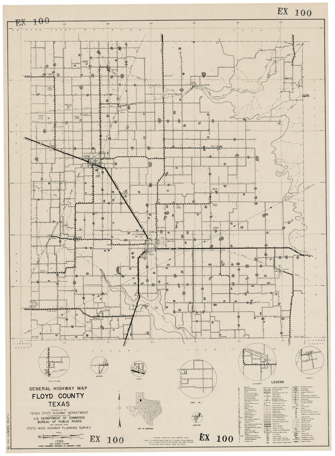
General Highway Map, Floyd County, Texas
EX100
-
Map/Doc
92973
-
Collection
Twichell Survey Records
-
Object Dates
1950 (Creation Date)
-
Counties
Floyd
-
Subjects
County
-
Height x Width
18.8 x 25.7 inches
47.8 x 65.3 cm
Part of: Twichell Survey Records
Part of Garza, Crosby, Lynn, and Lubbock Counties

Print $20.00
- Digital $50.00
Part of Garza, Crosby, Lynn, and Lubbock Counties
1912
Size 39.6 x 26.0 inches
Map/Doc 92560
[H. & G. N. Block 1]
![90943, [H. & G. N. Block 1], Twichell Survey Records](https://historictexasmaps.com/wmedia_w700/maps/90943-1.tif.jpg)
Print $20.00
- Digital $50.00
[H. & G. N. Block 1]
1873
Size 14.3 x 17.6 inches
Map/Doc 90943
[Texas Boundary Line]
![92081, [Texas Boundary Line], Twichell Survey Records](https://historictexasmaps.com/wmedia_w700/maps/92081-1.tif.jpg)
Print $20.00
- Digital $50.00
[Texas Boundary Line]
Size 21.2 x 12.4 inches
Map/Doc 92081
[Map of Portion of Pecos County as Surveyed by F. F. Friend]
![91562, [Map of Portion of Pecos County as Surveyed by F. F. Friend], Twichell Survey Records](https://historictexasmaps.com/wmedia_w700/maps/91562-1.tif.jpg)
Print $3.00
- Digital $50.00
[Map of Portion of Pecos County as Surveyed by F. F. Friend]
1926
Size 17.0 x 11.4 inches
Map/Doc 91562
[Map of Counties south of Panhandle]
![92960, [Map of Counties south of Panhandle], Twichell Survey Records](https://historictexasmaps.com/wmedia_w700/maps/92960-1.tif.jpg)
Print $20.00
- Digital $50.00
[Map of Counties south of Panhandle]
Size 22.1 x 15.8 inches
Map/Doc 92960
Slaughter Addition, Morton, Texas

Print $3.00
- Digital $50.00
Slaughter Addition, Morton, Texas
1951
Size 16.6 x 11.8 inches
Map/Doc 92541
[Sketch of Blocks Z and 194, showing tie lines with Runnels County School Land survey]
![91665, [Sketch of Blocks Z and 194, showing tie lines with Runnels County School Land survey], Twichell Survey Records](https://historictexasmaps.com/wmedia_w700/maps/91665-1.tif.jpg)
Print $20.00
- Digital $50.00
[Sketch of Blocks Z and 194, showing tie lines with Runnels County School Land survey]
Size 21.5 x 15.5 inches
Map/Doc 91665
Highland Place an Addition to City of Lubbock

Print $20.00
- Digital $50.00
Highland Place an Addition to City of Lubbock
Size 25.9 x 22.1 inches
Map/Doc 92844
[Sketch showing surveys on the north side of the Canadian River, Blocks B-11, L, O-18, and G and M 2 and 3]
![91737, [Sketch showing surveys on the north side of the Canadian River, Blocks B-11, L, O-18, and G and M 2 and 3], Twichell Survey Records](https://historictexasmaps.com/wmedia_w700/maps/91737-1.tif.jpg)
Print $20.00
- Digital $50.00
[Sketch showing surveys on the north side of the Canadian River, Blocks B-11, L, O-18, and G and M 2 and 3]
1883
Size 35.4 x 25.3 inches
Map/Doc 91737
[John S. Stephens Blk. S2, Lgs. 174-177, 186-193, 201-209]
![90104, [John S. Stephens Blk. S2, Lgs. 174-177, 186-193, 201-209], Twichell Survey Records](https://historictexasmaps.com/wmedia_w700/maps/90104-1.tif.jpg)
Print $2.00
- Digital $50.00
[John S. Stephens Blk. S2, Lgs. 174-177, 186-193, 201-209]
1912
Size 11.3 x 8.8 inches
Map/Doc 90104
Plat Showing Sections 11, 12, 19, and 20, Block A-9 Public School Land, Gaines County, Texas

Print $20.00
- Digital $50.00
Plat Showing Sections 11, 12, 19, and 20, Block A-9 Public School Land, Gaines County, Texas
1958
Size 18.2 x 21.8 inches
Map/Doc 92652
Texas Boundary Line

Print $20.00
- Digital $50.00
Texas Boundary Line
Size 21.6 x 11.9 inches
Map/Doc 92078
You may also like
Wise County Rolled Sketch 8

Print $20.00
- Digital $50.00
Wise County Rolled Sketch 8
Size 24.0 x 36.0 inches
Map/Doc 93554
Presidio County Rolled Sketch 70

Print $20.00
- Digital $50.00
Presidio County Rolled Sketch 70
1927
Size 37.1 x 13.9 inches
Map/Doc 7360
Kaufman County Sketch File 11

Print $4.00
- Digital $50.00
Kaufman County Sketch File 11
1874
Size 10.2 x 8.4 inches
Map/Doc 28645

Morris County Rolled Sketch 2A

Print $20.00
- Digital $50.00
Morris County Rolled Sketch 2A
Size 36.2 x 19.3 inches
Map/Doc 10282
Atascosa County Sketch File 42

Print $12.00
- Digital $50.00
Atascosa County Sketch File 42
1916
Size 11.2 x 8.8 inches
Map/Doc 13847
Fort Bend County Sketch File 4a

Print $40.00
- Digital $50.00
Fort Bend County Sketch File 4a
1887
Size 15.8 x 12.3 inches
Map/Doc 22887
Flight Mission No. BRA-7M, Frame 119, Jefferson County

Print $20.00
- Digital $50.00
Flight Mission No. BRA-7M, Frame 119, Jefferson County
1953
Size 18.5 x 22.4 inches
Map/Doc 85513
Goliad County Working Sketch 20

Print $20.00
- Digital $50.00
Goliad County Working Sketch 20
1955
Size 31.4 x 22.8 inches
Map/Doc 63210
Record of Field Notes in Austin's Colony

Record of Field Notes in Austin's Colony
1837
Map/Doc 96673
[Blocks A, RG, O, B, S and 11]
![92858, [Blocks A, RG, O, B, S and 11], Twichell Survey Records](https://historictexasmaps.com/wmedia_w700/maps/92858-1.tif.jpg)
Print $20.00
- Digital $50.00
[Blocks A, RG, O, B, S and 11]
1921
Size 25.2 x 15.5 inches
Map/Doc 92858
[George Gentry, Charles Welch, and Surrounding Surveys]
![91082, [George Gentry, Charles Welch, and Surrounding Surveys], Twichell Survey Records](https://historictexasmaps.com/wmedia_w700/maps/91082-1.tif.jpg)
Print $20.00
- Digital $50.00
[George Gentry, Charles Welch, and Surrounding Surveys]
1922
Size 28.6 x 32.0 inches
Map/Doc 91082