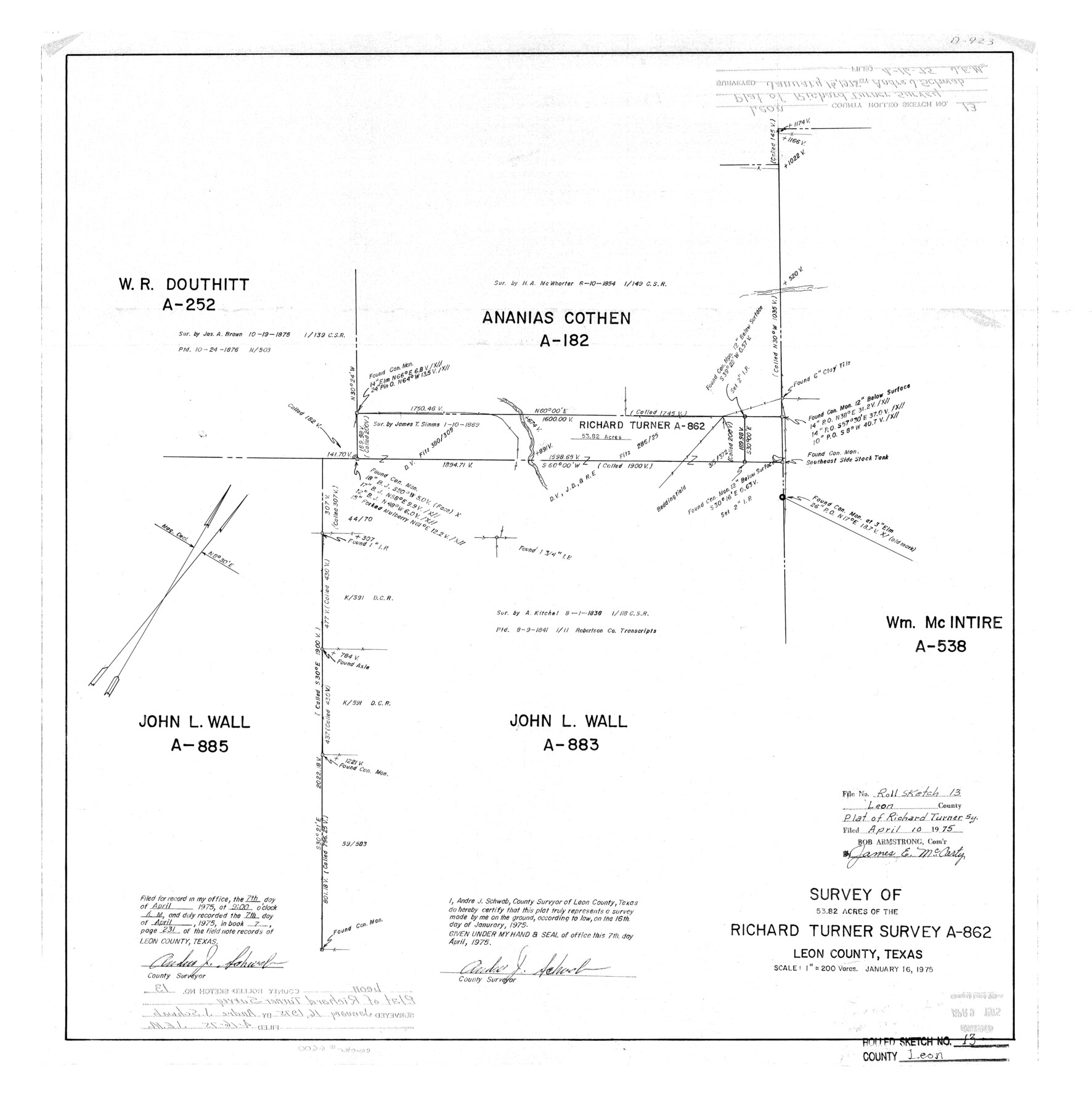
Leon County Rolled Sketch 13
Survey of 53.82 acres of the Richard Turner survey A-862, Leon County, Texas
-
Map/Doc
6600
-
Collection
General Map Collection
-
Object Dates
1975/1/16 (Survey Date)
1975/4/10 (File Date)
1975/4/7 (Creation Date)
-
People and Organizations
Andre J. Schwab (Surveyor/Engineer)
-
Counties
Leon
-
Subjects
Surveying Rolled Sketch
-
Height x Width
22.8 x 22.5 inches
57.9 x 57.2 cm
-
Scale
1" = 200 varas
Part of: General Map Collection
Leon County Rolled Sketch 22

Print $20.00
- Digital $50.00
Leon County Rolled Sketch 22
1983
Size 29.9 x 27.1 inches
Map/Doc 6608
Wichita County Sketch File E

Print $40.00
- Digital $50.00
Wichita County Sketch File E
Size 14.2 x 15.6 inches
Map/Doc 40072
Midland County Working Sketch 9

Print $20.00
- Digital $50.00
Midland County Working Sketch 9
1951
Size 42.6 x 35.9 inches
Map/Doc 70989
Uvalde County Working Sketch 11

Print $20.00
- Digital $50.00
Uvalde County Working Sketch 11
1943
Size 17.6 x 16.6 inches
Map/Doc 72081
El Paso County Rolled Sketch 52

Print $20.00
- Digital $50.00
El Paso County Rolled Sketch 52
1960
Size 18.4 x 24.4 inches
Map/Doc 5841
Trinity County Working Sketch 8

Print $3.00
- Digital $50.00
Trinity County Working Sketch 8
1941
Size 14.7 x 10.8 inches
Map/Doc 69457
Brooks County Working Sketch 9

Print $20.00
- Digital $50.00
Brooks County Working Sketch 9
1931
Size 25.7 x 38.7 inches
Map/Doc 67793
Upton County Working Sketch 50

Print $20.00
- Digital $50.00
Upton County Working Sketch 50
1980
Size 19.5 x 21.4 inches
Map/Doc 69547
Armstrong County

Print $20.00
- Digital $50.00
Armstrong County
1933
Size 42.3 x 41.0 inches
Map/Doc 73071
Brewster County Rolled Sketch 147

Print $20.00
- Digital $50.00
Brewster County Rolled Sketch 147
1986
Size 24.6 x 24.8 inches
Map/Doc 5313
Polk County Working Sketch 37

Print $20.00
- Digital $50.00
Polk County Working Sketch 37
1974
Size 31.3 x 38.2 inches
Map/Doc 71654
Edwards County Working Sketch 16

Print $20.00
- Digital $50.00
Edwards County Working Sketch 16
1929
Size 21.5 x 21.5 inches
Map/Doc 68892
You may also like
Brewster County Rolled Sketch 114

Print $20.00
- Digital $50.00
Brewster County Rolled Sketch 114
1964
Size 12.0 x 17.5 inches
Map/Doc 5291
DeWitt County Boundary File 2

Print $30.00
- Digital $50.00
DeWitt County Boundary File 2
Size 10.6 x 8.0 inches
Map/Doc 52498
Aransas County Working Sketch 15

Print $20.00
- Digital $50.00
Aransas County Working Sketch 15
1956
Size 22.2 x 19.0 inches
Map/Doc 67182
Working Sketch from Lynn & Garza Counties

Print $20.00
- Digital $50.00
Working Sketch from Lynn & Garza Counties
1902
Size 35.8 x 30.6 inches
Map/Doc 93223
[West Half of Potter County, South of River and West Half of Randall County]
![91828, [West Half of Potter County, South of River and West Half of Randall County], Twichell Survey Records](https://historictexasmaps.com/wmedia_w700/maps/91828.tif.jpg)
Print $20.00
- Digital $50.00
[West Half of Potter County, South of River and West Half of Randall County]
Size 25.9 x 43.0 inches
Map/Doc 91828
[Movements & Objectives of the 143rd & 144th Infantry & 133rd Machine Gun Battalion on October 8-9, 1918, Appendix E, No. 4] - Verso
![94134, [Movements & Objectives of the 143rd & 144th Infantry & 133rd Machine Gun Battalion on October 8-9, 1918, Appendix E, No. 4] - Verso, Non-GLO Digital Images](https://historictexasmaps.com/wmedia_w700/maps/94134-1.tif.jpg)
Print $20.00
[Movements & Objectives of the 143rd & 144th Infantry & 133rd Machine Gun Battalion on October 8-9, 1918, Appendix E, No. 4] - Verso
1918
Size 21.5 x 20.0 inches
Map/Doc 94134
Milam County Working Sketch 4

Print $20.00
- Digital $50.00
Milam County Working Sketch 4
1954
Size 26.1 x 32.4 inches
Map/Doc 71019
Kimble County

Print $40.00
- Digital $50.00
Kimble County
1930
Size 41.0 x 49.0 inches
Map/Doc 77340
Flight Mission No. CRE-2R, Frame 160, Jackson County

Print $20.00
- Digital $50.00
Flight Mission No. CRE-2R, Frame 160, Jackson County
1956
Size 18.5 x 22.3 inches
Map/Doc 85371
Angelina County Working Sketch 33

Print $20.00
- Digital $50.00
Angelina County Working Sketch 33
1955
Size 22.7 x 24.2 inches
Map/Doc 67116
Webb County Working Sketch 1

Print $20.00
- Digital $50.00
Webb County Working Sketch 1
Size 15.6 x 14.4 inches
Map/Doc 72366
Galveston Bay and Approaches

Print $20.00
- Digital $50.00
Galveston Bay and Approaches
1966
Size 43.3 x 32.6 inches
Map/Doc 69879