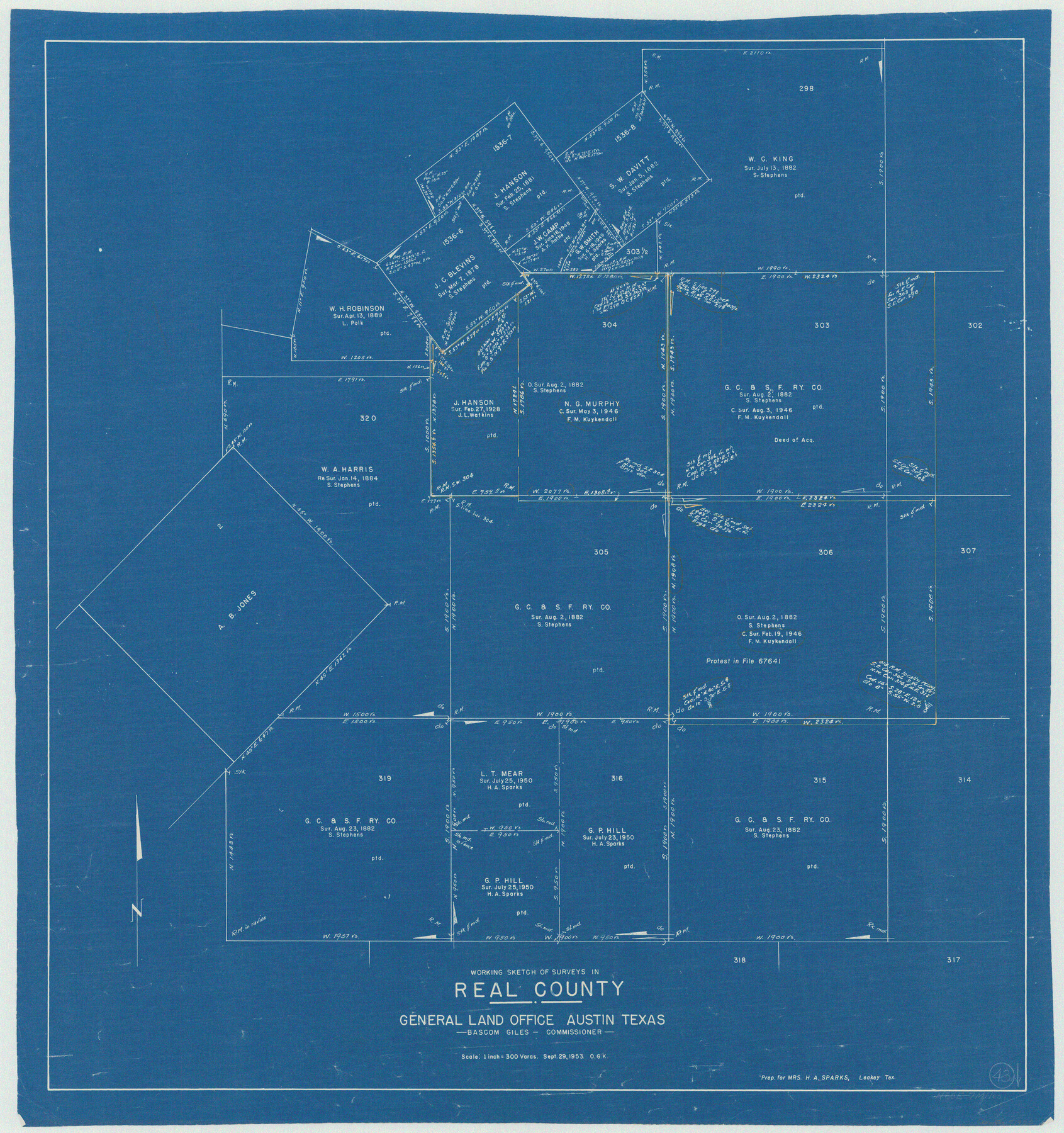
Real County Working Sketch 43
-
Map/Doc
71935
-
Collection
General Map Collection
-
Object Dates
9/29/1953 (Creation Date)
-
People and Organizations
Otto G. Kurio (Draftsman)
-
Counties
Real
-
Subjects
Surveying Working Sketch
-
Height x Width
32.4 x 30.5 inches
82.3 x 77.5 cm
-
Scale
1" = 300 varas
Part of: General Map Collection
Flight Mission No. DIX-5P, Frame 104, Aransas County

Print $20.00
- Digital $50.00
Flight Mission No. DIX-5P, Frame 104, Aransas County
1956
Size 17.8 x 18.5 inches
Map/Doc 83782
Tarrant County

Print $20.00
- Digital $50.00
Tarrant County
1857
Size 20.9 x 15.4 inches
Map/Doc 4628
Terry County Sketch File 5

Print $40.00
- Digital $50.00
Terry County Sketch File 5
1916
Size 15.6 x 58.6 inches
Map/Doc 10391
Presidio County Working Sketch 17

Print $20.00
- Digital $50.00
Presidio County Working Sketch 17
1943
Size 17.5 x 30.9 inches
Map/Doc 71693
Intracoastal Waterway in Texas - Corpus Christi to Point Isabel including Arroyo Colorado to Mo. Pac. R.R. Bridge Near Harlingen

Print $20.00
- Digital $50.00
Intracoastal Waterway in Texas - Corpus Christi to Point Isabel including Arroyo Colorado to Mo. Pac. R.R. Bridge Near Harlingen
1934
Size 21.9 x 32.5 inches
Map/Doc 61881
America's Fun-Tier: Texas 1967 Official State Highway Map

Digital $50.00
America's Fun-Tier: Texas 1967 Official State Highway Map
Size 28.2 x 36.4 inches
Map/Doc 94321
Intracoastal Waterway, Houma, LA to Corpus Christi, TX

Print $5.00
- Digital $50.00
Intracoastal Waterway, Houma, LA to Corpus Christi, TX
Size 22.3 x 28.0 inches
Map/Doc 61914
Flight Mission No. DQN-3K, Frame 32, Calhoun County

Print $20.00
- Digital $50.00
Flight Mission No. DQN-3K, Frame 32, Calhoun County
1953
Size 18.6 x 22.3 inches
Map/Doc 84345
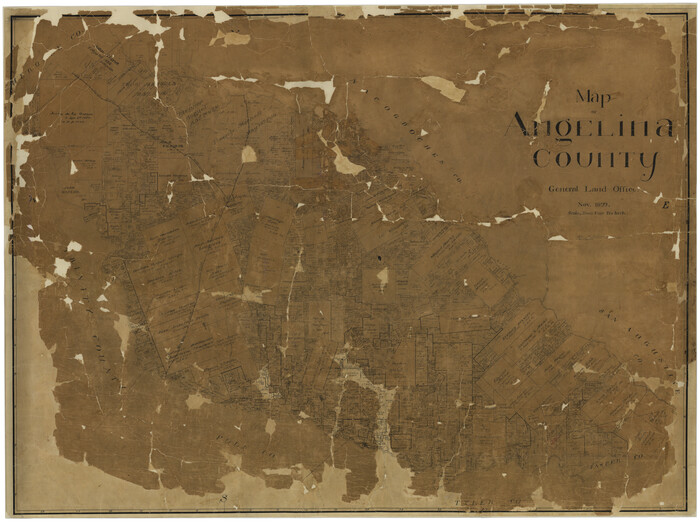
Map of Angelina County
Print $40.00
- Digital $50.00
Map of Angelina County
1899
Size 39.1 x 52.3 inches
Map/Doc 4777
Brewster County Rolled Sketch 114

Print $20.00
- Digital $50.00
Brewster County Rolled Sketch 114
1964
Size 11.5 x 17.5 inches
Map/Doc 5287
Goliad County Working Sketch 10

Print $20.00
- Digital $50.00
Goliad County Working Sketch 10
1939
Size 39.9 x 42.4 inches
Map/Doc 63200
Orange County NRC Article 33.136 Sketch 6

Print $42.00
Orange County NRC Article 33.136 Sketch 6
2025
Map/Doc 97430
You may also like
Collin County Boundary File 18d

Print $20.00
- Digital $50.00
Collin County Boundary File 18d
Size 12.8 x 8.2 inches
Map/Doc 51739
Hamilton County Working Sketch 23

Print $20.00
- Digital $50.00
Hamilton County Working Sketch 23
1955
Size 23.5 x 31.2 inches
Map/Doc 63361
Refugio County Working Sketch 3

Print $20.00
- Digital $50.00
Refugio County Working Sketch 3
1927
Size 21.9 x 24.6 inches
Map/Doc 63512
Culberson County Rolled Sketch 47

Print $20.00
- Digital $50.00
Culberson County Rolled Sketch 47
1959
Size 35.1 x 31.5 inches
Map/Doc 8755
Bandera County Working Sketch 1

Print $2.00
- Digital $50.00
Bandera County Working Sketch 1
Size 8.5 x 10.1 inches
Map/Doc 67594
Smith County Rolled Sketch 6A3

Print $40.00
- Digital $50.00
Smith County Rolled Sketch 6A3
1990
Size 48.6 x 36.8 inches
Map/Doc 10698
Mappa Geographica Americae Septentrionalis: ad emendatiora exemplaria adhuc edita jussu Acad. Reg. Scient. Et eleg. Litt. Descripta.

Print $20.00
- Digital $50.00
Mappa Geographica Americae Septentrionalis: ad emendatiora exemplaria adhuc edita jussu Acad. Reg. Scient. Et eleg. Litt. Descripta.
1753
Size 14.9 x 17.4 inches
Map/Doc 88882
Right of Way & Track Map, St. Louis, Brownsville & Mexico Ry. operated by St. Louis, Brownsville & Mexico Ry. Co.

Print $40.00
- Digital $50.00
Right of Way & Track Map, St. Louis, Brownsville & Mexico Ry. operated by St. Louis, Brownsville & Mexico Ry. Co.
1919
Size 25.4 x 56.9 inches
Map/Doc 64614
Map of El Paso County

Print $20.00
- Digital $50.00
Map of El Paso County
1888
Size 47.1 x 39.5 inches
Map/Doc 4942
Brazoria County Rolled Sketch 42

Print $20.00
- Digital $50.00
Brazoria County Rolled Sketch 42
1962
Size 35.0 x 44.5 inches
Map/Doc 8461
Coke County Sketch File 5

Print $8.00
- Digital $50.00
Coke County Sketch File 5
1886
Size 12.4 x 8.2 inches
Map/Doc 18578
Padre Island National Seashore

Print $20.00
- Digital $50.00
Padre Island National Seashore
Size 16.0 x 21.7 inches
Map/Doc 60537