Old Miscellaneous File 18
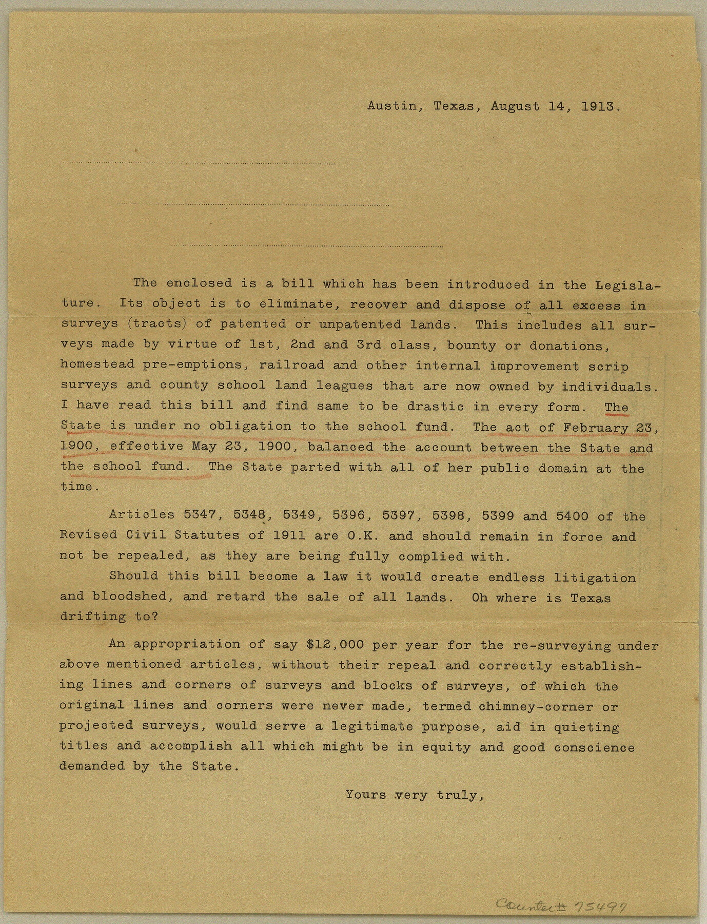
Letter regarding pending Bill on excess in surveys of patented and unpatented lands
-
Map/Doc
75497
-
Collection
General Map Collection
-
Object Dates
1913/8/14 (Creation Date)
1984/12/13 (File Date)
-
Subjects
Public School Land
-
Height x Width
11.3 x 8.6 inches
28.7 x 21.8 cm
Part of: General Map Collection
Lynn County Boundary File 9a

Print $80.00
- Digital $50.00
Lynn County Boundary File 9a
Size 9.3 x 6.4 inches
Map/Doc 56669
Panola County Working Sketch 23

Print $20.00
- Digital $50.00
Panola County Working Sketch 23
1951
Map/Doc 71432

Right of Way and Track Map Houston & Texas Central R.R. operated by the T. & N.O. R.R. Co., Austin Branch

Print $40.00
- Digital $50.00
Right of Way and Track Map Houston & Texas Central R.R. operated by the T. & N.O. R.R. Co., Austin Branch
1918
Size 25.5 x 57.7 inches
Map/Doc 64553
Uvalde County Rolled Sketch 18

Print $20.00
- Digital $50.00
Uvalde County Rolled Sketch 18
Size 33.2 x 24.8 inches
Map/Doc 8102
Sutton County Sketch File 61

Print $14.00
- Digital $50.00
Sutton County Sketch File 61
1986
Size 11.2 x 8.9 inches
Map/Doc 37557
Val Verde County Working Sketch 82

Print $20.00
- Digital $50.00
Val Verde County Working Sketch 82
1973
Size 42.1 x 33.1 inches
Map/Doc 72217
Red River County Working Sketch 34

Print $20.00
- Digital $50.00
Red River County Working Sketch 34
1963
Size 25.8 x 33.1 inches
Map/Doc 72017
Brooks County Boundary File Index

Print $2.00
- Digital $50.00
Brooks County Boundary File Index
Size 8.6 x 3.1 inches
Map/Doc 50808

Shelby County Sketch File 16 1/2

Print $4.00
- Digital $50.00
Shelby County Sketch File 16 1/2
Size 7.6 x 5.3 inches
Map/Doc 36629
Lynn County Boundary File 4

Print $4.00
- Digital $50.00
Lynn County Boundary File 4
Size 11.3 x 8.7 inches
Map/Doc 56626
You may also like
Old Miscellaneous File 21

Print $16.00
- Digital $50.00
Old Miscellaneous File 21
Size 14.3 x 8.7 inches
Map/Doc 75583
Bee County Sketch File 30

Print $6.00
- Digital $50.00
Bee County Sketch File 30
Size 14.2 x 8.9 inches
Map/Doc 14341
Flight Mission No. DQO-7K, Frame 83, Galveston County

Print $20.00
- Digital $50.00
Flight Mission No. DQO-7K, Frame 83, Galveston County
1952
Size 18.8 x 22.5 inches
Map/Doc 85110
Haskell County Boundary File 5

Print $80.00
- Digital $50.00
Haskell County Boundary File 5
Size 16.5 x 11.9 inches
Map/Doc 54578
Collingsworth County Sketch File 3

Print $20.00
- Digital $50.00
Collingsworth County Sketch File 3
1888
Size 32.5 x 27.7 inches
Map/Doc 11130
The Chief Justice County of Red River. Undated

Print $20.00
The Chief Justice County of Red River. Undated
2020
Size 16.6 x 21.8 inches
Map/Doc 96065
Flight Mission No. DQN-2K, Frame 41, Calhoun County

Print $20.00
- Digital $50.00
Flight Mission No. DQN-2K, Frame 41, Calhoun County
1953
Size 18.5 x 22.2 inches
Map/Doc 84246
Anderson County Working Sketch 42

Print $40.00
- Digital $50.00
Anderson County Working Sketch 42
1987
Size 34.4 x 51.1 inches
Map/Doc 67042
Flight Mission No. DQO-1K, Frame 117, Galveston County

Print $20.00
- Digital $50.00
Flight Mission No. DQO-1K, Frame 117, Galveston County
1952
Size 18.9 x 22.5 inches
Map/Doc 84995
Edwards County Working Sketch 80

Print $20.00
- Digital $50.00
Edwards County Working Sketch 80
1963
Size 23.4 x 23.2 inches
Map/Doc 68956
Orange County Sketch File 15

Print $6.00
- Digital $50.00
Orange County Sketch File 15
1900
Size 11.0 x 15.4 inches
Map/Doc 33330
Duval County Working Sketch 56

Print $20.00
- Digital $50.00
Duval County Working Sketch 56
1989
Size 26.7 x 27.2 inches
Map/Doc 68780