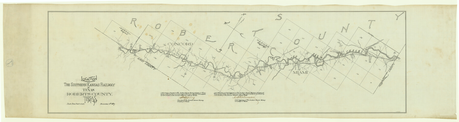
Location of the Southern Kansas Railway of Texas, Roberts County, Texas
Z-2-7
-
Map/Doc
64037
-
Collection
General Map Collection
-
Object Dates
1887/12/6 (Creation Date)
-
People and Organizations
A.A. Robinson (Surveyor/Engineer)
-
Counties
Gray Roberts
-
Subjects
Railroads
-
Height x Width
20.0 x 75.1 inches
50.8 x 190.8 cm
-
Medium
linen, manuscript
-
Scale
1"=2000 feet
-
Comments
Segment 2; see counter no. 64033 for segment 1.
See counter nos. 64035 through 64037 for other sheets. -
Features
SKR
Concord
Miami
Red Deer Creek
Part of: General Map Collection
Brewster County Rolled Sketch 15

Print $20.00
- Digital $50.00
Brewster County Rolled Sketch 15
1889
Size 32.8 x 26.4 inches
Map/Doc 5194
Blanco County Working Sketch 30

Print $20.00
- Digital $50.00
Blanco County Working Sketch 30
1971
Size 22.9 x 34.6 inches
Map/Doc 67390
Texas Gulf Coast Bay Index Map

Print $20.00
- Digital $50.00
Texas Gulf Coast Bay Index Map
Size 43.7 x 42.6 inches
Map/Doc 73599
McCulloch County Working Sketch 19

Print $20.00
- Digital $50.00
McCulloch County Working Sketch 19
2010
Size 32.6 x 27.0 inches
Map/Doc 89260
Waller County Working Sketch 3

Print $20.00
- Digital $50.00
Waller County Working Sketch 3
1959
Size 35.4 x 28.8 inches
Map/Doc 72302
Flight Mission No. CGI-3N, Frame 102, Cameron County

Print $20.00
- Digital $50.00
Flight Mission No. CGI-3N, Frame 102, Cameron County
1954
Size 18.6 x 22.2 inches
Map/Doc 84582
Nueces County Rolled Sketch 121

Print $32.00
Nueces County Rolled Sketch 121
1994
Size 18.2 x 24.5 inches
Map/Doc 7152

[Edwards Co.]
![66811, [Edwards Co.], General Map Collection](https://historictexasmaps.com/wmedia_w700/maps/66811.tif.jpg)
Print $20.00
- Digital $50.00
[Edwards Co.]
1910
Size 38.8 x 36.2 inches
Map/Doc 66811
Flight Mission No. BRA-6M, Frame 147, Jefferson County

Print $20.00
- Digital $50.00
Flight Mission No. BRA-6M, Frame 147, Jefferson County
1953
Size 18.6 x 22.4 inches
Map/Doc 85448
Presidio County Rolled Sketch 143

Print $20.00
- Digital $50.00
Presidio County Rolled Sketch 143
Size 40.2 x 36.8 inches
Map/Doc 90046
Galveston County Sketch File 27a

Print $23.00
- Digital $50.00
Galveston County Sketch File 27a
1899
Size 13.6 x 8.8 inches
Map/Doc 23399
You may also like
Kinney County Rolled Sketch 13

Print $20.00
- Digital $50.00
Kinney County Rolled Sketch 13
1949
Size 24.9 x 37.4 inches
Map/Doc 77562
Gray's New Map of Texas and the Indian Territory

Print $20.00
- Digital $50.00
Gray's New Map of Texas and the Indian Territory
1876
Size 17.4 x 27.7 inches
Map/Doc 93786
Potter County Sketch File 14

Print $20.00
- Digital $50.00
Potter County Sketch File 14
Size 16.5 x 22.5 inches
Map/Doc 12200
Guadalupe County Working Sketch Graphic Index

Print $20.00
- Digital $50.00
Guadalupe County Working Sketch Graphic Index
1977
Size 35.5 x 46.5 inches
Map/Doc 76561
Map of Comanche County

Print $20.00
Map of Comanche County
1876
Size 28.0 x 24.1 inches
Map/Doc 88919
Sketch of a part of Galveston Island

Print $3.00
- Digital $50.00
Sketch of a part of Galveston Island
Size 10.8 x 13.8 inches
Map/Doc 430
Rusk County Sketch File Z

Print $6.00
Rusk County Sketch File Z
1850
Size 15.8 x 9.0 inches
Map/Doc 35539
Gillespie County Rolled Sketch 10

Print $3.00
- Digital $50.00
Gillespie County Rolled Sketch 10
2017
Size 16.1 x 10.7 inches
Map/Doc 94413
Sketch from Reeves and Pecos Co's.

Print $20.00
- Digital $50.00
Sketch from Reeves and Pecos Co's.
Size 35.1 x 26.1 inches
Map/Doc 91779
General Highway Map, Brazoria County, Texas

Print $20.00
General Highway Map, Brazoria County, Texas
1939
Size 18.6 x 25.0 inches
Map/Doc 79024
Erath County Working Sketch 31

Print $20.00
- Digital $50.00
Erath County Working Sketch 31
1970
Size 23.2 x 26.2 inches
Map/Doc 69112
[Location, Fort Worth & Denver Railroad, through Wilbarger County]
![64345, [Location, Fort Worth & Denver Railroad, through Wilbarger County], General Map Collection](https://historictexasmaps.com/wmedia_w700/maps/64345.tif.jpg)
Print $40.00
- Digital $50.00
[Location, Fort Worth & Denver Railroad, through Wilbarger County]
Size 20.7 x 92.7 inches
Map/Doc 64345