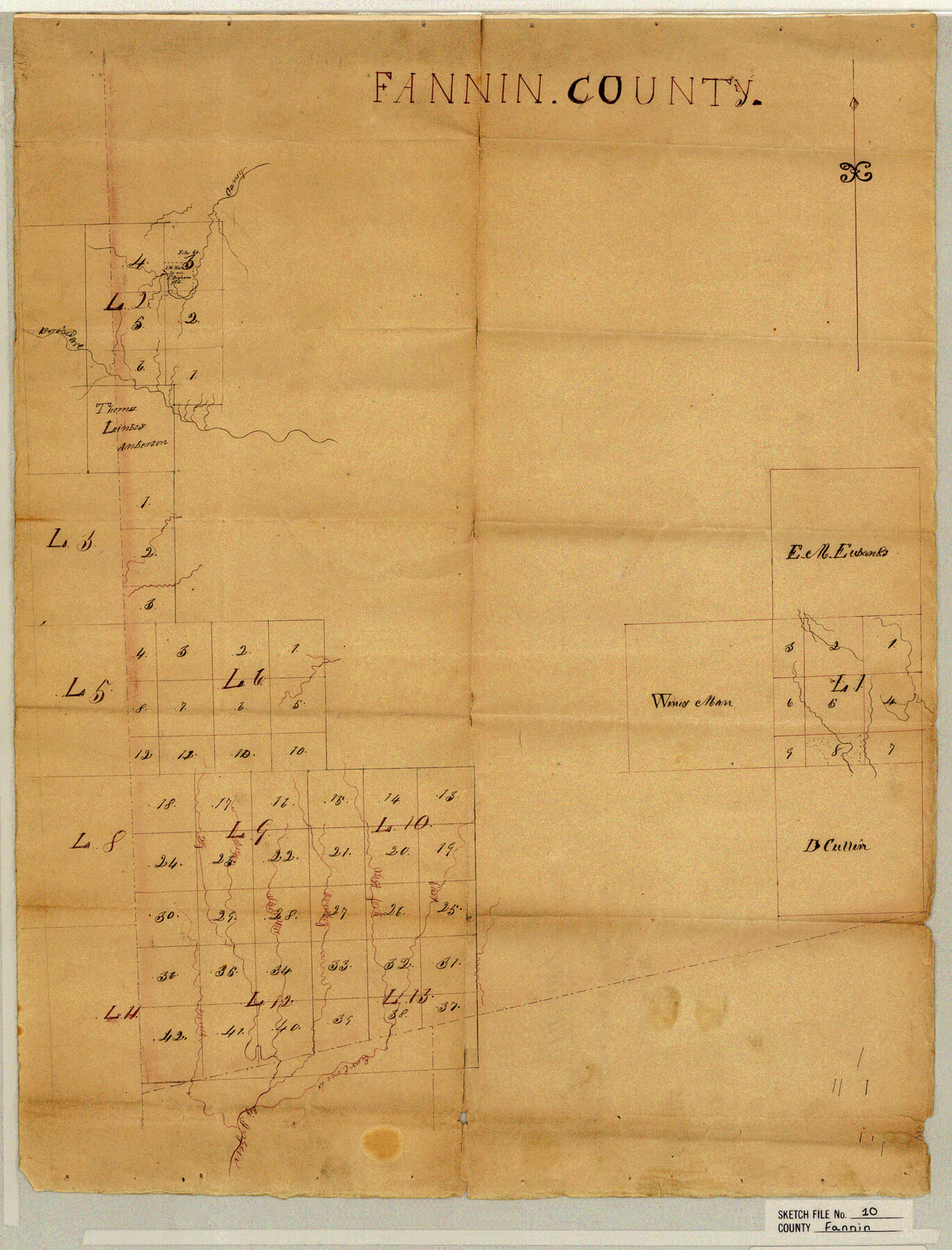
Fannin County Sketch File 10
On the south part of the Co.
-
Map/Doc
11471
-
Collection
General Map Collection
-
Counties
Fannin
-
Subjects
Surveying Sketch File
-
Height x Width
21.0 x 16.0 inches
53.3 x 40.6 cm
-
Medium
paper, manuscript
-
Features
Caney Creek
Bois D'Arc Creek
Bear Creek
East Fork [of Bear Creek]
West Fork [of Bear Creek]
Brushy Creek
Sicamore [sic] Creek
Dry Creek
Part of: General Map Collection

Flight Mission No. DAG-21K, Frame 32, Matagorda County

Print $20.00
- Digital $50.00
Flight Mission No. DAG-21K, Frame 32, Matagorda County
1952
Size 18.6 x 22.4 inches
Map/Doc 86399
Flight Mission No. DQN-5K, Frame 76, Calhoun County

Print $20.00
- Digital $50.00
Flight Mission No. DQN-5K, Frame 76, Calhoun County
1953
Size 18.7 x 22.3 inches
Map/Doc 84409
Sutton County Rolled Sketch 47

Print $20.00
- Digital $50.00
Sutton County Rolled Sketch 47
Size 17.0 x 24.3 inches
Map/Doc 7888
Map of Parker County

Print $20.00
- Digital $50.00
Map of Parker County
1879
Size 23.9 x 19.0 inches
Map/Doc 3947
Childress County

Print $20.00
- Digital $50.00
Childress County
1892
Size 36.2 x 27.1 inches
Map/Doc 3392
Matagorda Light to Aransas Pass

Print $20.00
- Digital $50.00
Matagorda Light to Aransas Pass
1981
Size 36.6 x 44.5 inches
Map/Doc 73402
Webb County Sketch File 11b-1

Print $20.00
- Digital $50.00
Webb County Sketch File 11b-1
1880
Size 21.7 x 19.3 inches
Map/Doc 12627
Flight Mission No. CRC-3R, Frame 202, Chambers County

Print $20.00
- Digital $50.00
Flight Mission No. CRC-3R, Frame 202, Chambers County
1956
Size 18.7 x 22.4 inches
Map/Doc 84857
Flight Mission No. DQO-1K, Frame 94, Galveston County

Print $20.00
- Digital $50.00
Flight Mission No. DQO-1K, Frame 94, Galveston County
1952
Size 18.9 x 22.6 inches
Map/Doc 84990
Bailey County Sketch File 12

Print $8.00
- Digital $50.00
Bailey County Sketch File 12
Size 8.3 x 12.0 inches
Map/Doc 13969
Kent County Boundary File 6

Print $4.00
- Digital $50.00
Kent County Boundary File 6
Size 14.1 x 8.8 inches
Map/Doc 55868
You may also like
Index Map No. 1 - Rio Bravo del Norte section of boundary between the United States & Mexico; agreed upon by the Joint Commission under the Treaty of Guadalupe Hidalgo

Print $20.00
- Digital $50.00
Index Map No. 1 - Rio Bravo del Norte section of boundary between the United States & Mexico; agreed upon by the Joint Commission under the Treaty of Guadalupe Hidalgo
1852
Size 18.3 x 27.5 inches
Map/Doc 72861
[Location Survey of the Southern Kansas Railway, Kiowa Extension from a point in Drake's Location, in Indian Territory 100 miles from south line of Kansas, continuing up Wolf Creek and South Canadian River to Cottonwood Creek in Hutchinson County]
![88842, [Location Survey of the Southern Kansas Railway, Kiowa Extension from a point in Drake's Location, in Indian Territory 100 miles from south line of Kansas, continuing up Wolf Creek and South Canadian River to Cottonwood Creek in Hutchinson County], General Map Collection](https://historictexasmaps.com/wmedia_w700/maps/88842.tif.jpg)
Print $20.00
- Digital $50.00
[Location Survey of the Southern Kansas Railway, Kiowa Extension from a point in Drake's Location, in Indian Territory 100 miles from south line of Kansas, continuing up Wolf Creek and South Canadian River to Cottonwood Creek in Hutchinson County]
1886
Size 39.0 x 42.0 inches
Map/Doc 88842
Flight Mission No. CUG-3P, Frame 161, Kleberg County

Print $20.00
- Digital $50.00
Flight Mission No. CUG-3P, Frame 161, Kleberg County
1956
Size 18.6 x 22.5 inches
Map/Doc 86281
Crockett County Working Sketch 21

Print $20.00
- Digital $50.00
Crockett County Working Sketch 21
1920
Size 18.5 x 24.8 inches
Map/Doc 68354
Milam County Boundary File 1

Print $8.00
- Digital $50.00
Milam County Boundary File 1
Size 12.7 x 8.2 inches
Map/Doc 57198
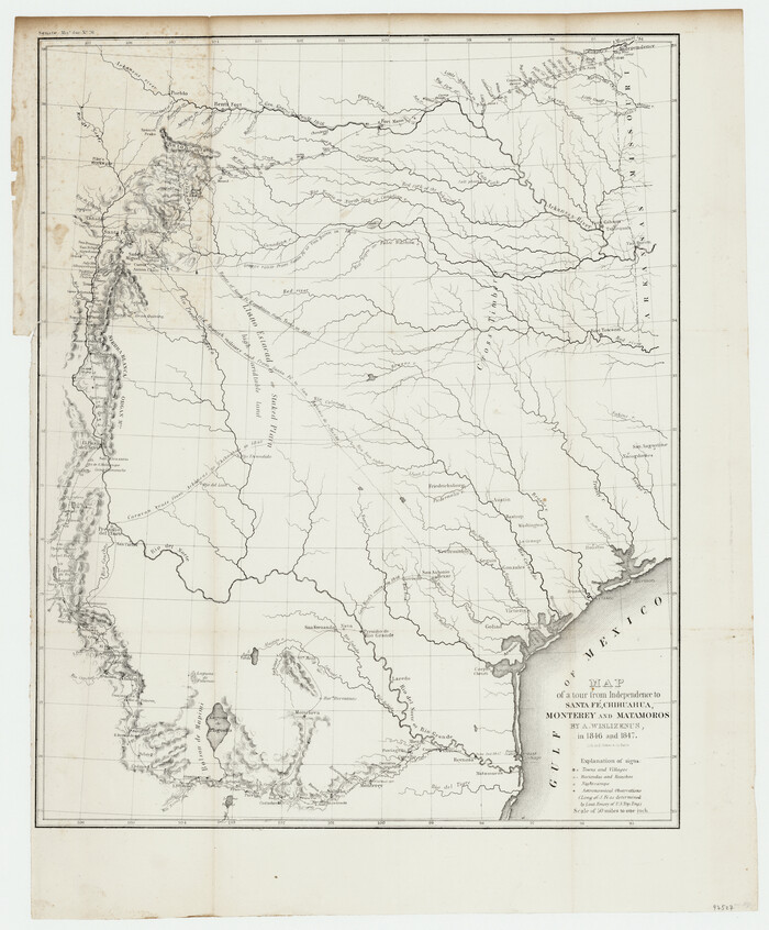
Map of a tour from Independence to Santa Fé, Chihuahua, Monterey and Matamoros by A. Wislizenus, in 1846 and 1847
Print $20.00
- Digital $50.00
Map of a tour from Independence to Santa Fé, Chihuahua, Monterey and Matamoros by A. Wislizenus, in 1846 and 1847
1848
Size 23.2 x 19.2 inches
Map/Doc 97527
Flight Mission No. CUI-1H, Frame 141, Milam County

Print $20.00
- Digital $50.00
Flight Mission No. CUI-1H, Frame 141, Milam County
1951
Size 18.4 x 22.3 inches
Map/Doc 86607
Andrews County Rolled Sketch 6

Print $40.00
- Digital $50.00
Andrews County Rolled Sketch 6
1928
Size 43.9 x 56.9 inches
Map/Doc 8363
Bandera County Working Sketch 54

Print $20.00
- Digital $50.00
Bandera County Working Sketch 54
1988
Size 30.4 x 30.1 inches
Map/Doc 67650
Hudspeth County Working Sketch 38

Print $20.00
- Digital $50.00
Hudspeth County Working Sketch 38
1978
Size 31.8 x 36.9 inches
Map/Doc 66323

Map showing S. A. & A. P. Ry. from San Antonio to Kendall County line

Print $40.00
- Digital $50.00
Map showing S. A. & A. P. Ry. from San Antonio to Kendall County line
1895
Size 25.1 x 76.7 inches
Map/Doc 64254