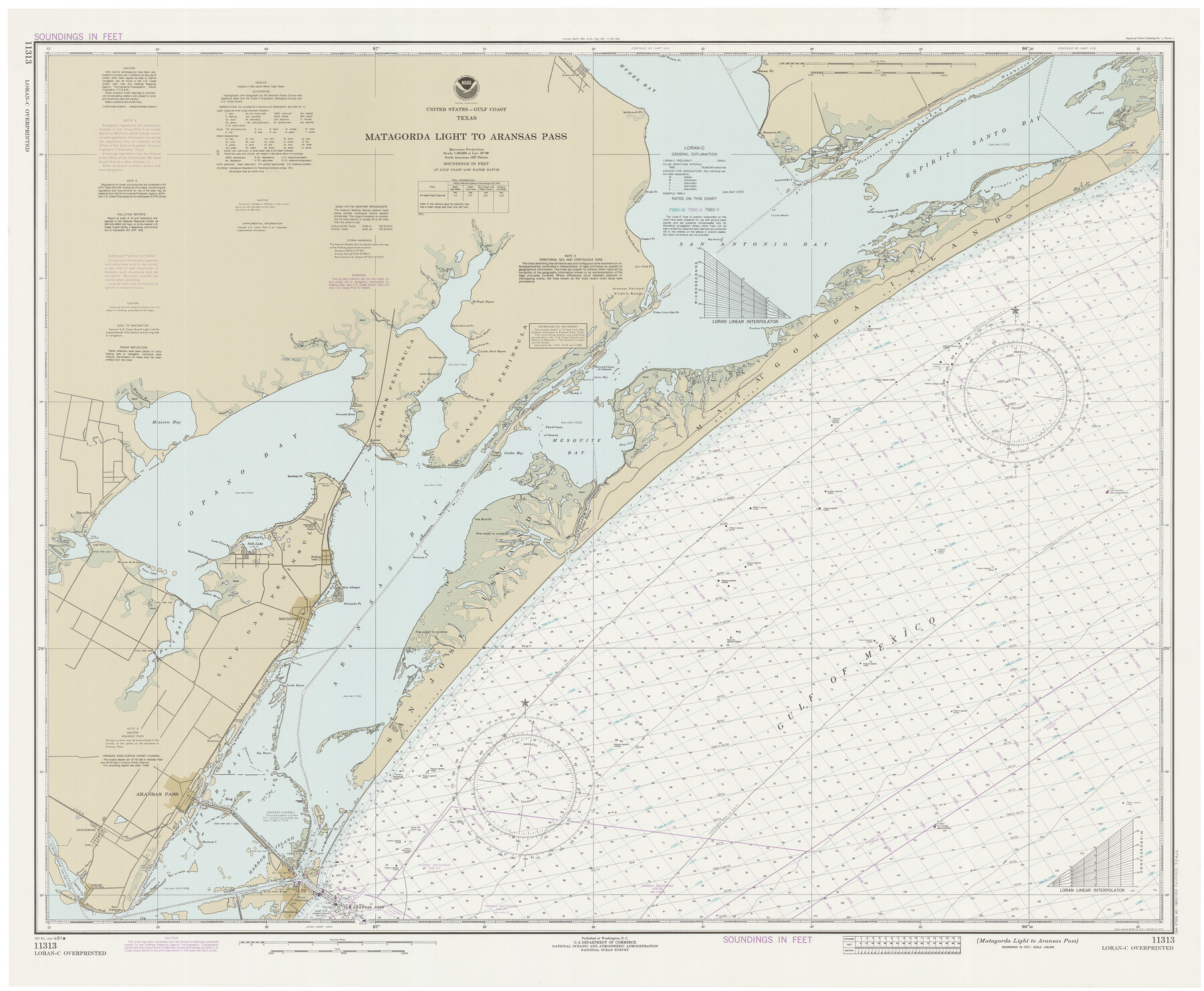
Matagorda Light to Aransas Pass
K-6-1285a
-
Map/Doc
73402
-
Collection
General Map Collection
-
Object Dates
7/18/1981 (Creation Date)
-
Counties
Refugio San Patricio Aransas
-
Subjects
Nautical Charts
-
Height x Width
36.6 x 44.5 inches
93.0 x 113.0 cm
Part of: General Map Collection
Brazoria County Sketch File 18

Print $18.00
- Digital $50.00
Brazoria County Sketch File 18
Size 14.5 x 8.9 inches
Map/Doc 14989
Maverick County Working Sketch 21

Print $20.00
- Digital $50.00
Maverick County Working Sketch 21
1977
Size 34.6 x 24.0 inches
Map/Doc 70913
Gillespie County Boundary File 3

Print $34.00
- Digital $50.00
Gillespie County Boundary File 3
Size 14.3 x 8.8 inches
Map/Doc 53736
Little River, Faubion Bridge Sheet

Print $4.00
- Digital $50.00
Little River, Faubion Bridge Sheet
1914
Size 19.0 x 27.8 inches
Map/Doc 65060
Ellis County Sketch File 1

Print $6.00
- Digital $50.00
Ellis County Sketch File 1
1849
Size 6.5 x 7.9 inches
Map/Doc 21824
Archer County Working Sketch 20

Print $20.00
- Digital $50.00
Archer County Working Sketch 20
1975
Size 31.7 x 24.4 inches
Map/Doc 67161
Lipscomb County Boundary File 7

Print $4.00
- Digital $50.00
Lipscomb County Boundary File 7
Size 6.6 x 8.1 inches
Map/Doc 56331
Gulf Oil Corp. Fishgide - Port Isabel

Gulf Oil Corp. Fishgide - Port Isabel
1960
Size 22.0 x 11.9 inches
Map/Doc 75980
Ward County Working Sketch 39

Print $20.00
- Digital $50.00
Ward County Working Sketch 39
1969
Size 24.2 x 45.5 inches
Map/Doc 72345
Pecos County Rolled Sketch 69A

Print $20.00
- Digital $50.00
Pecos County Rolled Sketch 69A
1928
Size 44.3 x 35.9 inches
Map/Doc 9702
Mason County Sketch File 5

Print $20.00
- Digital $50.00
Mason County Sketch File 5
1875
Size 15.8 x 12.9 inches
Map/Doc 12033
Callahan County Rolled Sketch 5

Print $40.00
- Digital $50.00
Callahan County Rolled Sketch 5
Size 52.0 x 44.1 inches
Map/Doc 5382
You may also like
Flight Mission No. BRE-2P, Frame 11, Nueces County

Print $20.00
- Digital $50.00
Flight Mission No. BRE-2P, Frame 11, Nueces County
1956
Size 18.6 x 22.7 inches
Map/Doc 86720
[Gulf, Colorado & Santa Fe]
![64576, [Gulf, Colorado & Santa Fe], General Map Collection](https://historictexasmaps.com/wmedia_w700/maps/64576.tif.jpg)
Print $40.00
- Digital $50.00
[Gulf, Colorado & Santa Fe]
Size 32.4 x 84.9 inches
Map/Doc 64576
[Index map of T. & P. Ry. Company’s 80-mile Trans-Pecos Reserve’s perpetuated corners - South Part]
![69766, [Index map of T. & P. Ry. Company’s 80-mile Trans-Pecos Reserve’s perpetuated corners - South Part], General Map Collection](https://historictexasmaps.com/wmedia_w700/maps/69766.tif.jpg)
Print $40.00
- Digital $50.00
[Index map of T. & P. Ry. Company’s 80-mile Trans-Pecos Reserve’s perpetuated corners - South Part]
Size 23.1 x 90.1 inches
Map/Doc 69766
Wilbarger County Working Sketch 21

Print $20.00
- Digital $50.00
Wilbarger County Working Sketch 21
1979
Size 37.4 x 37.8 inches
Map/Doc 72559
University Lands Blocks 21 to 26, Pecos County, Texas

Print $40.00
- Digital $50.00
University Lands Blocks 21 to 26, Pecos County, Texas
1939
Size 48.4 x 39.9 inches
Map/Doc 2450
Flight Mission No. BQR-3K, Frame 84, Brazoria County

Print $20.00
- Digital $50.00
Flight Mission No. BQR-3K, Frame 84, Brazoria County
1952
Size 18.8 x 22.5 inches
Map/Doc 83976
Red River County Working Sketch 51

Print $20.00
- Digital $50.00
Red River County Working Sketch 51
1970
Size 31.2 x 28.5 inches
Map/Doc 72034
Childress County Working Sketch 3

Print $20.00
- Digital $50.00
Childress County Working Sketch 3
1927
Size 22.4 x 18.6 inches
Map/Doc 68019
Clay County Sketch File 38a

Print $6.00
- Digital $50.00
Clay County Sketch File 38a
1939
Size 14.3 x 8.8 inches
Map/Doc 18469
Lavaca County Sketch File 22

Print $28.00
- Digital $50.00
Lavaca County Sketch File 22
1959
Size 14.2 x 8.7 inches
Map/Doc 29654
Johnson's New Map of the State of Texas

Print $20.00
- Digital $50.00
Johnson's New Map of the State of Texas
1859
Size 18.6 x 26.8 inches
Map/Doc 89254
Hays County Boundary File 4

Print $4.00
- Digital $50.00
Hays County Boundary File 4
Size 5.1 x 8.9 inches
Map/Doc 54607