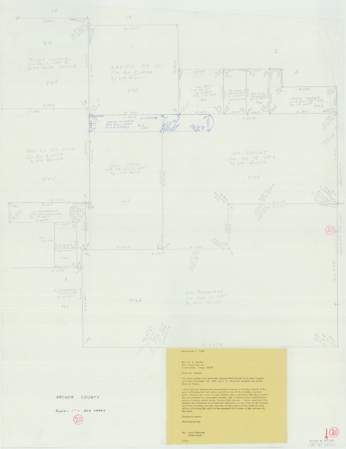
Archer County Working Sketch 20
-
Map/Doc
67161
-
Collection
General Map Collection
-
Object Dates
9/9/1975 (Creation Date)
-
People and Organizations
Bob Armstrong (GLO Commissioner)
-
Counties
Archer
-
Subjects
Surveying Working Sketch
-
Height x Width
31.7 x 24.4 inches
80.5 x 62.0 cm
-
Scale
1" = 300 varas
-
Comments
Surveys located about 13 miles South 55 degrees West of Archer City, Texas.
Part of: General Map Collection
Brewster County Sketch File 47

Print $12.00
- Digital $50.00
Brewster County Sketch File 47
1939
Size 14.1 x 8.8 inches
Map/Doc 16321
Freestone County Rolled Sketch 11

Print $20.00
- Digital $50.00
Freestone County Rolled Sketch 11
Size 23.3 x 33.9 inches
Map/Doc 5912
Culberson County Sketch File 15

Print $20.00
- Digital $50.00
Culberson County Sketch File 15
1933
Size 30.4 x 24.4 inches
Map/Doc 11267
Map of Ramon Musquiz Survey, Meanders of Lavaca & Navidad Rivers, Menefee & Redfish Lakes

Print $20.00
- Digital $50.00
Map of Ramon Musquiz Survey, Meanders of Lavaca & Navidad Rivers, Menefee & Redfish Lakes
1934
Size 23.0 x 18.6 inches
Map/Doc 65456
Calhoun County Boundary File 2

Print $50.00
- Digital $50.00
Calhoun County Boundary File 2
Size 9.1 x 7.7 inches
Map/Doc 50968
Fractional Township No. 9 South Range No. 1 East of the Indian Meridian, Indian Territory

Print $20.00
- Digital $50.00
Fractional Township No. 9 South Range No. 1 East of the Indian Meridian, Indian Territory
1898
Size 19.2 x 24.4 inches
Map/Doc 75201
Liberty County Working Sketch 49a

Print $20.00
- Digital $50.00
Liberty County Working Sketch 49a
1955
Size 32.7 x 39.9 inches
Map/Doc 70508
Fisher County

Print $40.00
- Digital $50.00
Fisher County
1944
Size 50.2 x 44.2 inches
Map/Doc 95497
Lipscomb County Working Sketch 6

Print $20.00
- Digital $50.00
Lipscomb County Working Sketch 6
1980
Size 35.7 x 20.8 inches
Map/Doc 70582
Atascosa County

Print $20.00
- Digital $50.00
Atascosa County
1948
Size 46.6 x 45.4 inches
Map/Doc 73072
San Saba County Rolled Sketch 1

Print $3.00
- Digital $50.00
San Saba County Rolled Sketch 1
Size 11.7 x 9.0 inches
Map/Doc 7742
Travis County Boundary File 32

Print $5.00
- Digital $50.00
Travis County Boundary File 32
Size 11.8 x 9.4 inches
Map/Doc 59473
You may also like
Galveston County NRC Article 33.136 Sketch 5

Print $20.00
- Digital $50.00
Galveston County NRC Article 33.136 Sketch 5
2001
Size 23.5 x 19.1 inches
Map/Doc 61587
Reeves County Sketch File 10

Print $20.00
- Digital $50.00
Reeves County Sketch File 10
Size 17.0 x 32.0 inches
Map/Doc 12244
Cass County Working Sketch 48

Print $20.00
- Digital $50.00
Cass County Working Sketch 48
1992
Size 21.3 x 36.4 inches
Map/Doc 67951
Scurry County Working Sketch 10

Print $20.00
- Digital $50.00
Scurry County Working Sketch 10
1990
Size 25.7 x 28.7 inches
Map/Doc 63839
[Part of Block GG and river sections 69-79]
![90470, [Part of Block GG and river sections 69-79], Twichell Survey Records](https://historictexasmaps.com/wmedia_w700/maps/90470-1.tif.jpg)
Print $20.00
- Digital $50.00
[Part of Block GG and river sections 69-79]
Size 43.2 x 31.2 inches
Map/Doc 90470
Flight Mission No. CGI-3N, Frame 145, Cameron County

Print $20.00
- Digital $50.00
Flight Mission No. CGI-3N, Frame 145, Cameron County
1954
Size 18.6 x 22.3 inches
Map/Doc 84618
Gonzales County Sketch File 11

Print $4.00
- Digital $50.00
Gonzales County Sketch File 11
1842
Size 12.8 x 7.9 inches
Map/Doc 24392
City of Littlefield Lamb County Texas Located on Texas State Capitol League 664

Print $20.00
- Digital $50.00
City of Littlefield Lamb County Texas Located on Texas State Capitol League 664
Size 41.0 x 37.1 inches
Map/Doc 89911
Brewster County Rolled Sketch 114

Print $20.00
- Digital $50.00
Brewster County Rolled Sketch 114
1964
Size 11.5 x 17.5 inches
Map/Doc 5287
General Highway Map, Calhoun County, Texas

Print $20.00
General Highway Map, Calhoun County, Texas
1940
Size 18.5 x 25.3 inches
Map/Doc 79036
The Land Offices. No. 10, Bexar, December 22, 1836

Print $20.00
The Land Offices. No. 10, Bexar, December 22, 1836
2020
Size 19.2 x 16.2 inches
Map/Doc 96423
[S.E. corner of Sec. 48, Blk. 35 T5N to N.E. corner of Sec. 1, Blk. 35 T5N]
![89826, [S.E. corner of Sec. 48, Blk. 35 T5N to N.E. corner of Sec. 1, Blk. 35 T5N], Twichell Survey Records](https://historictexasmaps.com/wmedia_w700/maps/89826-1.tif.jpg)
Print $40.00
- Digital $50.00
[S.E. corner of Sec. 48, Blk. 35 T5N to N.E. corner of Sec. 1, Blk. 35 T5N]
1907
Size 7.2 x 72.9 inches
Map/Doc 89826