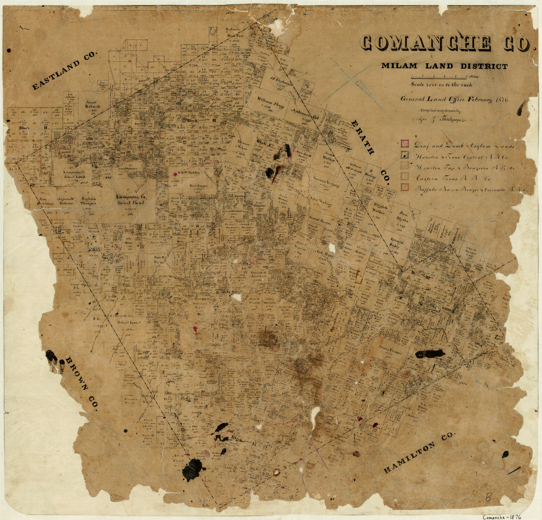
Comanche County Milam Land District
-
Map/Doc
3433
-
Collection
General Map Collection
-
Object Dates
2/1876 (Creation Date)
-
People and Organizations
Texas General Land Office (Publisher)
George J. Thielepape (Compiler)
George J. Thielepape (Draftsman)
-
Counties
Comanche
-
Subjects
County
-
Height x Width
22.1 x 23.0 inches
56.1 x 58.4 cm
-
Features
Sabano Creek
Leon River
North Leon River
South Leon River
Armstrong Creek
Sweetwater Creek
Copperas Creek
Walker Creek
Resley Creek
Duncan Creek
Rush Creek
Mercer Creek
Cowhouse Creek
Part of: General Map Collection
Ellis County Working Sketch 4

Print $40.00
- Digital $50.00
Ellis County Working Sketch 4
1997
Size 48.0 x 30.3 inches
Map/Doc 69020
Wichita County Working Sketch 27

Print $20.00
- Digital $50.00
Wichita County Working Sketch 27
1984
Size 35.6 x 34.6 inches
Map/Doc 72537
Val Verde County Working Sketch 13

Print $20.00
- Digital $50.00
Val Verde County Working Sketch 13
1922
Size 24.8 x 25.3 inches
Map/Doc 72148
Young County Sketch File 8a

Print $4.00
- Digital $50.00
Young County Sketch File 8a
1858
Size 9.8 x 8.0 inches
Map/Doc 40862
Garza County Rolled Sketch 5

Print $40.00
- Digital $50.00
Garza County Rolled Sketch 5
1906
Size 37.2 x 48.0 inches
Map/Doc 9050
Hale County Sketch File E

Print $20.00
- Digital $50.00
Hale County Sketch File E
1902
Size 15.2 x 21.5 inches
Map/Doc 11601
Blanco County Working Sketch 32

Print $20.00
- Digital $50.00
Blanco County Working Sketch 32
1972
Size 31.8 x 32.2 inches
Map/Doc 67392
Kinney County Working Sketch 55

Print $20.00
- Digital $50.00
Kinney County Working Sketch 55
1982
Size 25.1 x 24.7 inches
Map/Doc 70237
[Plat of Texas and Pacific Railroad Company Block Lines, 80 Mile Reserve]
![3124, [Plat of Texas and Pacific Railroad Company Block Lines, 80 Mile Reserve], General Map Collection](https://historictexasmaps.com/wmedia_w700/maps/3124-1.tif.jpg)
Print $40.00
- Digital $50.00
[Plat of Texas and Pacific Railroad Company Block Lines, 80 Mile Reserve]
1876
Size 43.5 x 46.3 inches
Map/Doc 3124

Matagorda County Sketch File 41

Print $6.00
- Digital $50.00
Matagorda County Sketch File 41
Size 10.2 x 12.1 inches
Map/Doc 30832
Map of the Fort Worth & Denver City Ry., Dallam County, Texas

Print $40.00
- Digital $50.00
Map of the Fort Worth & Denver City Ry., Dallam County, Texas
1887
Size 21.3 x 111.8 inches
Map/Doc 64352
You may also like
South Montgomery County, Woodlands Chamber of Commerce Street Map

South Montgomery County, Woodlands Chamber of Commerce Street Map
Size 50.0 x 37.8 inches
Map/Doc 94364
Duval County Rolled Sketch 38

Print $20.00
- Digital $50.00
Duval County Rolled Sketch 38
1937
Size 22.6 x 16.1 inches
Map/Doc 5755
Terrell County Working Sketch 9

Print $20.00
- Digital $50.00
Terrell County Working Sketch 9
1917
Size 18.9 x 23.0 inches
Map/Doc 62158
Map of Texas from the most recent authorities

Print $20.00
- Digital $50.00
Map of Texas from the most recent authorities
1845
Map/Doc 93945
Flight Mission No. DQN-2K, Frame 70, Calhoun County

Print $20.00
- Digital $50.00
Flight Mission No. DQN-2K, Frame 70, Calhoun County
1953
Size 18.7 x 22.3 inches
Map/Doc 84262
Upton County Sketch File 22

Print $4.00
- Digital $50.00
Upton County Sketch File 22
1927
Size 11.2 x 8.5 inches
Map/Doc 38877
Map of the State of Texas

Print $40.00
- Digital $50.00
Map of the State of Texas
1879
Size 102.7 x 106.6 inches
Map/Doc 16973
Stephens County Working Sketch 21

Print $20.00
- Digital $50.00
Stephens County Working Sketch 21
1975
Size 34.7 x 31.9 inches
Map/Doc 63964
[Sketch of part of G. & M. Block 5]
![93080, [Sketch of part of G. & M. Block 5], Twichell Survey Records](https://historictexasmaps.com/wmedia_w700/maps/93080-1.tif.jpg)
Print $20.00
- Digital $50.00
[Sketch of part of G. & M. Block 5]
Size 26.3 x 18.9 inches
Map/Doc 93080
King County Working Sketch 17

Print $40.00
- Digital $50.00
King County Working Sketch 17
1979
Size 32.2 x 59.3 inches
Map/Doc 70181
Kimble County Sketch File 4

Print $8.00
- Digital $50.00
Kimble County Sketch File 4
1847
Size 7.9 x 12.1 inches
Map/Doc 28912
University of Texas System University Lands

Print $20.00
- Digital $50.00
University of Texas System University Lands
1933
Size 23.0 x 17.7 inches
Map/Doc 93248