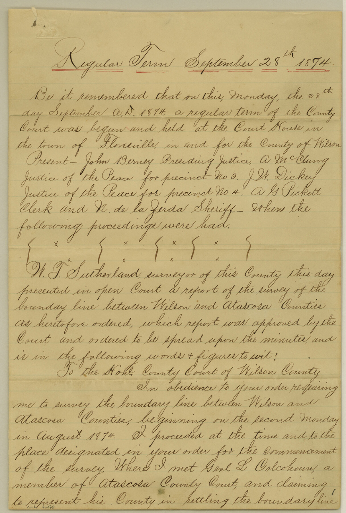
Wilson County Boundary File 2
County Line between Atascosa and Wilson
-
Map/Doc
60078
-
Collection
General Map Collection
-
Counties
Wilson
-
Subjects
County Boundaries
-
Height x Width
12.3 x 8.3 inches
31.2 x 21.1 cm
Part of: General Map Collection
Live Oak County Rolled Sketch 6

Print $20.00
- Digital $50.00
Live Oak County Rolled Sketch 6
1947
Size 43.6 x 25.9 inches
Map/Doc 6634
Real County Rolled Sketch 18

Print $20.00
- Digital $50.00
Real County Rolled Sketch 18
1986
Size 25.3 x 32.5 inches
Map/Doc 7469
Map of Nolan County

Print $20.00
- Digital $50.00
Map of Nolan County
1896
Size 28.8 x 23.5 inches
Map/Doc 3915
Jeff Davis County Sketch File 45

Print $10.00
- Digital $50.00
Jeff Davis County Sketch File 45
1890
Size 14.0 x 8.5 inches
Map/Doc 28075
Donley County Working Sketch 11

Print $20.00
- Digital $50.00
Donley County Working Sketch 11
1904
Size 43.7 x 41.1 inches
Map/Doc 68744
Flight Mission No. DAH-9M, Frame 197, Orange County

Print $20.00
- Digital $50.00
Flight Mission No. DAH-9M, Frame 197, Orange County
1953
Size 18.5 x 22.4 inches
Map/Doc 86865
Johnson County

Print $20.00
- Digital $50.00
Johnson County
1943
Size 42.0 x 38.8 inches
Map/Doc 73199

Texas Coast, No. 17

Print $20.00
- Digital $50.00
Texas Coast, No. 17
Size 18.3 x 27.6 inches
Map/Doc 72712
Mason County Rolled Sketch 4

Print $20.00
- Digital $50.00
Mason County Rolled Sketch 4
1983
Size 23.3 x 26.9 inches
Map/Doc 6677
Montague County Sketch File 13

Print $4.00
- Digital $50.00
Montague County Sketch File 13
1879
Size 8.9 x 9.0 inches
Map/Doc 31738
El Paso County Sketch File 11

Print $6.00
- Digital $50.00
El Paso County Sketch File 11
Size 14.2 x 11.0 inches
Map/Doc 22000
You may also like
Sutton County Working Sketch 2

Print $20.00
- Digital $50.00
Sutton County Working Sketch 2
1968
Size 31.2 x 29.3 inches
Map/Doc 62345
Pecos County Rolled Sketch 71

Print $20.00
- Digital $50.00
Pecos County Rolled Sketch 71
Size 21.9 x 47.6 inches
Map/Doc 9703
Shelby County Working Sketch 2

Print $20.00
- Digital $50.00
Shelby County Working Sketch 2
Size 32.9 x 37.3 inches
Map/Doc 63855

Edwards County Rolled Sketch JF

Print $20.00
- Digital $50.00
Edwards County Rolled Sketch JF
1915
Size 25.2 x 30.5 inches
Map/Doc 5819
[Ft. W. & R. G. Ry. Right of Way Map, Chapin to Bluffdale, Hood County, Texas]
![64644, [Ft. W. & R. G. Ry. Right of Way Map, Chapin to Bluffdale, Hood County, Texas], General Map Collection](https://historictexasmaps.com/wmedia_w700/maps/64644.tif.jpg)
Print $40.00
- Digital $50.00
[Ft. W. & R. G. Ry. Right of Way Map, Chapin to Bluffdale, Hood County, Texas]
1918
Size 37.7 x 84.3 inches
Map/Doc 64644
Crockett County Working Sketch 52

Print $20.00
- Digital $50.00
Crockett County Working Sketch 52
1941
Size 26.0 x 33.5 inches
Map/Doc 68385
Brewster County Sketch File D

Print $4.00
- Digital $50.00
Brewster County Sketch File D
1938
Size 14.5 x 8.8 inches
Map/Doc 15738
Edwards County Working Sketch 30

Print $20.00
- Digital $50.00
Edwards County Working Sketch 30
1947
Size 27.7 x 38.2 inches
Map/Doc 68906
Harris County Sketch File 22

Print $4.00
- Digital $50.00
Harris County Sketch File 22
1862
Size 9.1 x 9.4 inches
Map/Doc 25375
Northwest Part Crockett County

Print $40.00
- Digital $50.00
Northwest Part Crockett County
1983
Size 37.3 x 48.3 inches
Map/Doc 95470
Real County Working Sketch Graphic Index, Sheet 2 (Sketches 43 to Most Recent)

Print $20.00
- Digital $50.00
Real County Working Sketch Graphic Index, Sheet 2 (Sketches 43 to Most Recent)
1972
Size 43.2 x 31.1 inches
Map/Doc 76679