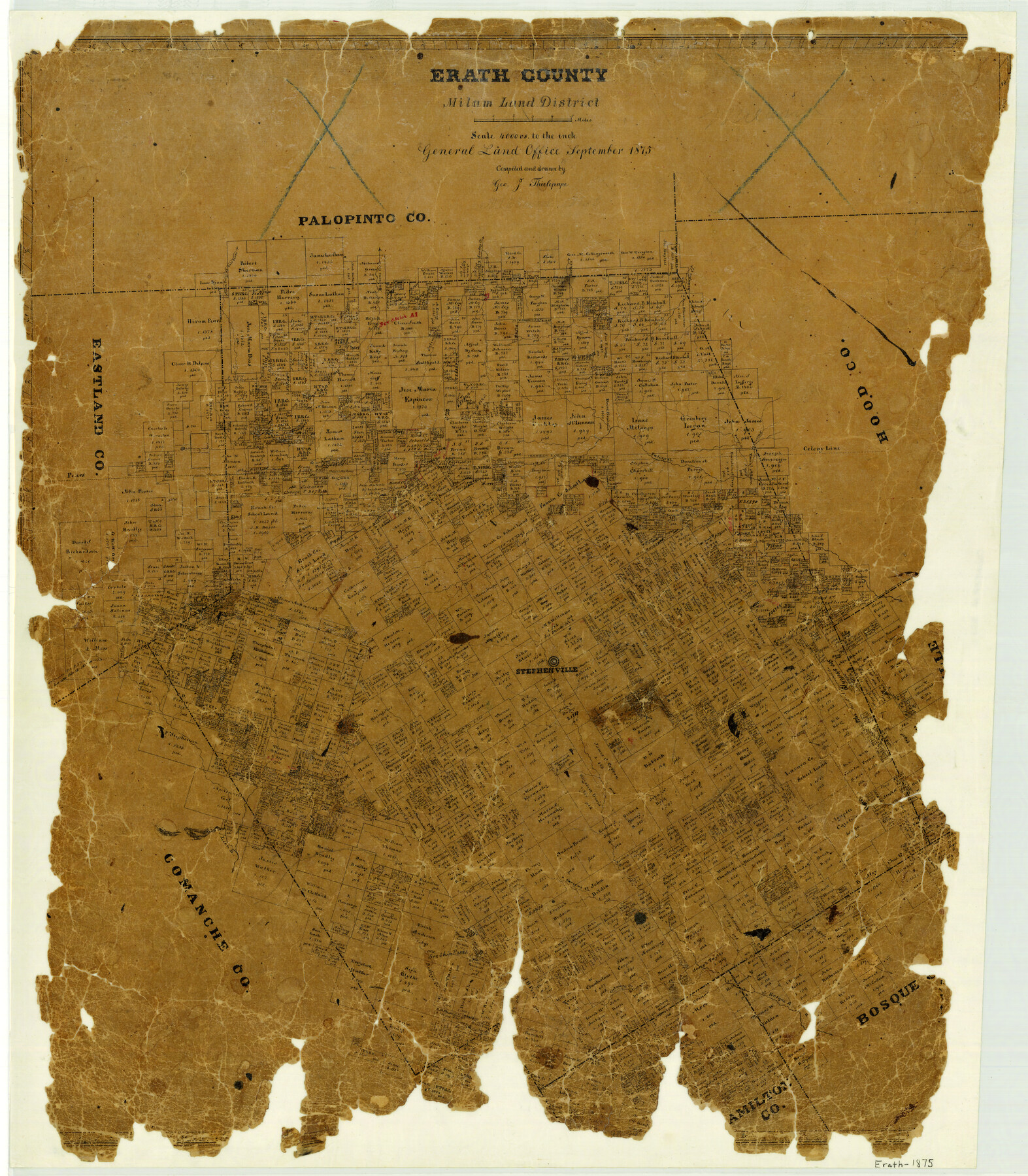
Erath County
-
Map/Doc
3522
-
Collection
General Map Collection
-
Object Dates
1875 (Creation Date)
-
People and Organizations
Texas General Land Office (Publisher)
George J. Thielepape (Draftsman)
George J. Thielepape (Compiler)
-
Counties
Erath
-
Subjects
County
-
Height x Width
28.4 x 24.9 inches
72.1 x 63.2 cm
-
Features
Stephenville
Saline Creek
Resleys Creek
Gilmore Creek
Bosque River
Duffau's Creek
Greens Creek
Leon River
Walkers Creek
Hog Creek
Armstrong's Creek
Ice Creek
East Leon River
Allcorns Creek
Perry's Creek
Paloxy Creek
Kikapoo [sic] Creek
Buck Creek
Sunday Creek
Bartons Creek
Palo Pinto Creek
South Prong of Palo Pinto Creek
Part of: General Map Collection
Dallas County Boundary File 5

Print $120.00
- Digital $50.00
Dallas County Boundary File 5
Size 11.5 x 72.2 inches
Map/Doc 52160
Mason County Sketch File 8

Print $4.00
- Digital $50.00
Mason County Sketch File 8
1876
Size 13.2 x 8.4 inches
Map/Doc 30691
Zavala County Rolled Sketch 27

Print $20.00
- Digital $50.00
Zavala County Rolled Sketch 27
1955
Size 21.2 x 20.0 inches
Map/Doc 8329
Reyno de la Nueva España a Principios del Siglo XIX

Print $20.00
- Digital $50.00
Reyno de la Nueva España a Principios del Siglo XIX
1885
Size 25.6 x 32.7 inches
Map/Doc 93751
Kerr County Working Sketch 7

Print $20.00
- Digital $50.00
Kerr County Working Sketch 7
1947
Size 38.9 x 30.8 inches
Map/Doc 70038
Real County Working Sketch 60

Print $40.00
- Digital $50.00
Real County Working Sketch 60
1963
Size 60.4 x 41.1 inches
Map/Doc 71952
Crane County Sketch File 7

Print $6.00
- Digital $50.00
Crane County Sketch File 7
1886
Size 10.3 x 11.0 inches
Map/Doc 19567
Pecos County Sketch File 49

Print $4.00
- Digital $50.00
Pecos County Sketch File 49
1900
Size 14.2 x 8.6 inches
Map/Doc 33764
Flight Mission No. BRA-7M, Frame 141, Jefferson County

Print $20.00
- Digital $50.00
Flight Mission No. BRA-7M, Frame 141, Jefferson County
1953
Size 18.6 x 22.4 inches
Map/Doc 85535
Hockley County Boundary File 3

Print $12.00
- Digital $50.00
Hockley County Boundary File 3
Size 4.1 x 8.6 inches
Map/Doc 54804
Smith County Sketch File 14

Print $4.00
- Digital $50.00
Smith County Sketch File 14
1888
Size 12.3 x 8.8 inches
Map/Doc 36775
Live Oak County Working Sketch 37

Print $40.00
- Digital $50.00
Live Oak County Working Sketch 37
2012
Size 34.4 x 48.7 inches
Map/Doc 93363
You may also like
Burnet County Sketch File 31

Print $4.00
- Digital $50.00
Burnet County Sketch File 31
1875
Size 12.7 x 8.1 inches
Map/Doc 16748
General Highway Map, Brazoria County, Texas

Print $20.00
General Highway Map, Brazoria County, Texas
1961
Size 25.0 x 18.2 inches
Map/Doc 79382
Harrison County Sketch File 11

Print $22.00
- Digital $50.00
Harrison County Sketch File 11
1904
Size 9.2 x 9.3 inches
Map/Doc 26052
DeWitt County Sketch File 4

Print $4.00
- Digital $50.00
DeWitt County Sketch File 4
1872
Size 8.3 x 13.1 inches
Map/Doc 20801
Pecos County Rolled Sketch 19 1/2

Print $20.00
- Digital $50.00
Pecos County Rolled Sketch 19 1/2
1885
Size 41.9 x 17.6 inches
Map/Doc 7208
Real County Working Sketch 64

Print $20.00
- Digital $50.00
Real County Working Sketch 64
1968
Size 31.4 x 30.0 inches
Map/Doc 71956
Concho County Boundary File 4

Print $2.00
- Digital $50.00
Concho County Boundary File 4
Size 12.7 x 8.4 inches
Map/Doc 51825
Potter County Working Sketch 10

Print $20.00
- Digital $50.00
Potter County Working Sketch 10
1964
Size 32.6 x 25.0 inches
Map/Doc 71670
Map of Jack County

Print $20.00
- Digital $50.00
Map of Jack County
1896
Size 20.3 x 17.7 inches
Map/Doc 3699
Right of Way and Track Map of The Wichita Falls & Southern Railroad Company

Print $40.00
- Digital $50.00
Right of Way and Track Map of The Wichita Falls & Southern Railroad Company
1942
Size 24.7 x 56.3 inches
Map/Doc 64521
Gulf Intracoastal Waterway, Tex. - Aransas Bay to Corpus Christi Bay - Modified Route of Main Channel/Dredging

Print $20.00
- Digital $50.00
Gulf Intracoastal Waterway, Tex. - Aransas Bay to Corpus Christi Bay - Modified Route of Main Channel/Dredging
1958
Size 31.5 x 43.0 inches
Map/Doc 61898
El Paso County Boundary File 25

Print $10.00
- Digital $50.00
El Paso County Boundary File 25
Size 13.0 x 8.9 inches
Map/Doc 53226