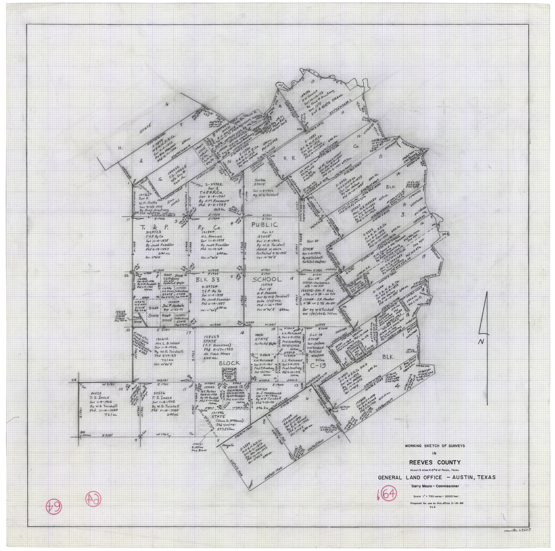
Reeves County Working Sketch 64
-
Map/Doc
63507
-
Collection
General Map Collection
-
Object Dates
2/16/1984 (Creation Date)
-
People and Organizations
Crockett L. Slover (Draftsman)
-
Counties
Reeves
-
Subjects
Surveying Working Sketch
-
Height x Width
26.3 x 26.5 inches
66.8 x 67.3 cm
-
Scale
1" = 720 varas
Part of: General Map Collection
Map of Coleman County

Print $20.00
- Digital $50.00
Map of Coleman County
Size 26.8 x 19.8 inches
Map/Doc 3408
San Antonio, Texas Street Map

San Antonio, Texas Street Map
1997
Size 36.5 x 46.7 inches
Map/Doc 96868
[Surveys in the Robertson District along the Trinity River and Richland Creek]
![104, [Surveys in the Robertson District along the Trinity River and Richland Creek], General Map Collection](https://historictexasmaps.com/wmedia_w700/maps/104.tif.jpg)
Print $20.00
- Digital $50.00
[Surveys in the Robertson District along the Trinity River and Richland Creek]
1841
Size 15.3 x 12.2 inches
Map/Doc 104
Live Oak County Rolled Sketch 7

Print $20.00
- Digital $50.00
Live Oak County Rolled Sketch 7
1951
Size 31.3 x 36.9 inches
Map/Doc 6635
Bosque County, Texas School Map

Print $20.00
- Digital $50.00
Bosque County, Texas School Map
1932
Size 40.9 x 36.6 inches
Map/Doc 81918
Throckmorton County

Print $20.00
- Digital $50.00
Throckmorton County
1943
Size 46.7 x 37.4 inches
Map/Doc 95653
Flight Mission No. DQN-7K, Frame 13, Calhoun County

Print $20.00
- Digital $50.00
Flight Mission No. DQN-7K, Frame 13, Calhoun County
1953
Size 18.4 x 22.1 inches
Map/Doc 84464
Flight Mission No. BRA-6M, Frame 78, Jefferson County

Print $20.00
- Digital $50.00
Flight Mission No. BRA-6M, Frame 78, Jefferson County
1953
Size 18.7 x 22.4 inches
Map/Doc 85422
Calhoun County Rolled Sketch 12

Print $40.00
- Digital $50.00
Calhoun County Rolled Sketch 12
1940
Size 30.2 x 54.8 inches
Map/Doc 43619
La Salle County Working Sketch 22

Print $20.00
- Digital $50.00
La Salle County Working Sketch 22
1942
Size 36.2 x 29.2 inches
Map/Doc 70323
Presidio County Rolled Sketch 93A

Print $20.00
- Digital $50.00
Presidio County Rolled Sketch 93A
Size 29.6 x 28.2 inches
Map/Doc 7379
Oldham County Working Sketch 9

Print $20.00
- Digital $50.00
Oldham County Working Sketch 9
1982
Size 33.3 x 37.2 inches
Map/Doc 71331
You may also like
Lubbock County

Print $20.00
- Digital $50.00
Lubbock County
1892
Size 20.1 x 19.3 inches
Map/Doc 3828
Uvalde County Working Sketch 52

Print $20.00
- Digital $50.00
Uvalde County Working Sketch 52
1982
Size 45.2 x 35.8 inches
Map/Doc 72122
Henderson County Sketch File 9

Print $8.00
- Digital $50.00
Henderson County Sketch File 9
Size 8.3 x 7.8 inches
Map/Doc 26343
Nueces County Sketch File 21

Print $8.00
- Digital $50.00
Nueces County Sketch File 21
1880
Size 5.9 x 5.5 inches
Map/Doc 32557
Gregg County Boundary File 8

Print $8.00
- Digital $50.00
Gregg County Boundary File 8
Size 14.0 x 8.6 inches
Map/Doc 54019
Real County Working Sketch 36

Print $20.00
- Digital $50.00
Real County Working Sketch 36
1950
Size 24.7 x 35.9 inches
Map/Doc 71928
Kerr County Working Sketch 11

Print $20.00
- Digital $50.00
Kerr County Working Sketch 11
1951
Size 30.3 x 29.9 inches
Map/Doc 70042
Presidio County Rolled Sketch 117

Print $20.00
- Digital $50.00
Presidio County Rolled Sketch 117
Size 29.1 x 28.8 inches
Map/Doc 7392
Wise County Sketch File 34

Print $6.00
- Digital $50.00
Wise County Sketch File 34
1856
Size 6.3 x 9.6 inches
Map/Doc 40592
Duval County Sketch File 87

Print $12.00
- Digital $50.00
Duval County Sketch File 87
1991
Size 11.0 x 8.5 inches
Map/Doc 21549
Richardson's New Map of the State of Texas, corrected for the Texas Almanac to 1872

Print $20.00
- Digital $50.00
Richardson's New Map of the State of Texas, corrected for the Texas Almanac to 1872
1872
Size 18.4 x 26.4 inches
Map/Doc 93647
Terrell County Working Sketch 85

Print $20.00
- Digital $50.00
Terrell County Working Sketch 85
1994
Size 31.3 x 42.8 inches
Map/Doc 69609