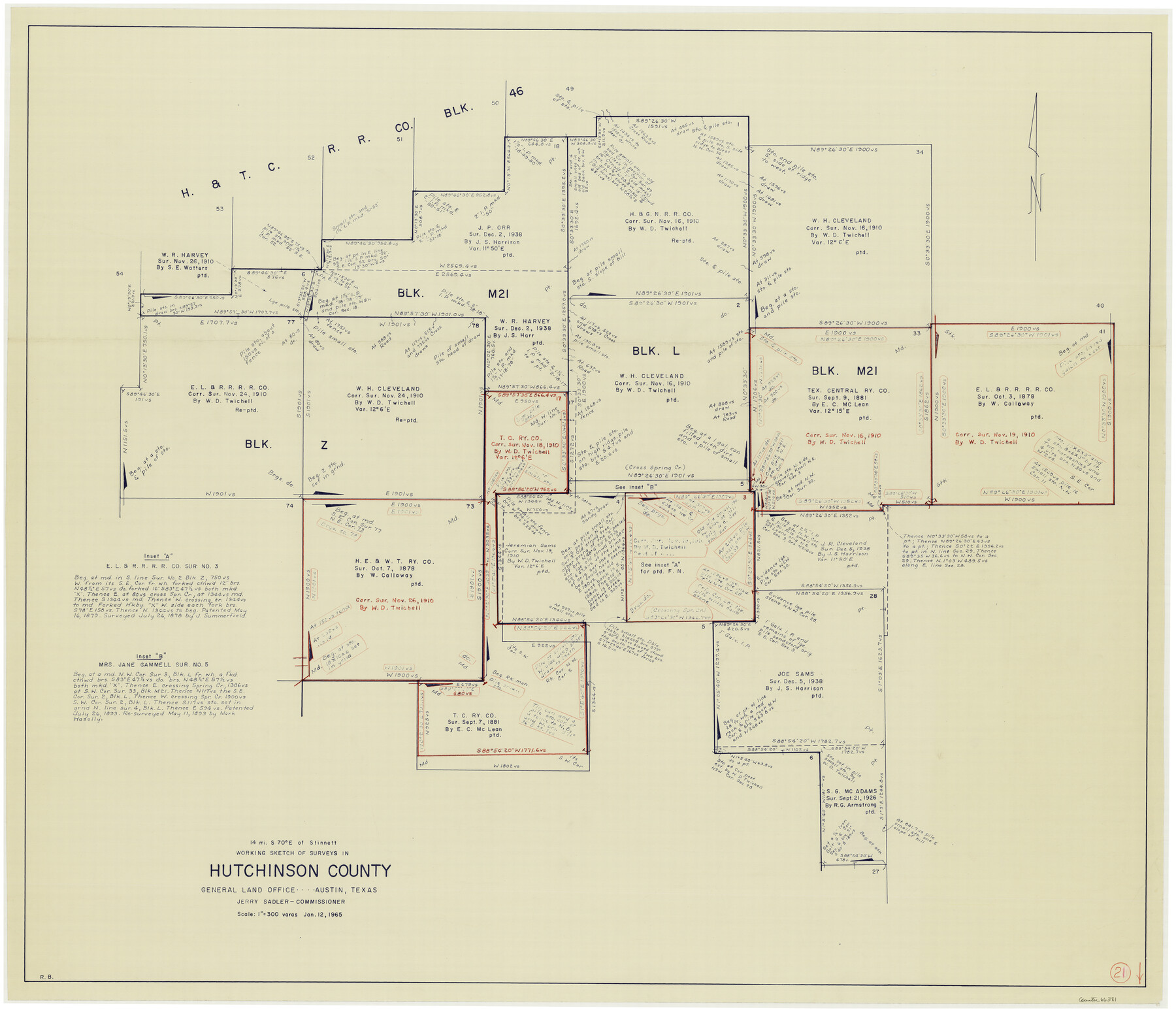
Hutchinson County Working Sketch 21
-
Map/Doc
66381
-
Collection
General Map Collection
-
Object Dates
1/12/1965 (Creation Date)
-
People and Organizations
Roy Buckholts (Draftsman)
-
Counties
Hutchinson
-
Subjects
Surveying Working Sketch
-
Height x Width
35.0 x 40.8 inches
88.9 x 103.6 cm
-
Scale
1" = 300 varas
Part of: General Map Collection
Hidalgo County Rolled Sketch 12

Print $20.00
- Digital $50.00
Hidalgo County Rolled Sketch 12
1908
Size 21.3 x 27.9 inches
Map/Doc 6211
San Jacinto County Working Sketch 22

Print $20.00
- Digital $50.00
San Jacinto County Working Sketch 22
1940
Size 21.3 x 25.3 inches
Map/Doc 63735
Brewster County Rolled Sketch 154

Print $20.00
- Digital $50.00
Brewster County Rolled Sketch 154
2001
Size 36.3 x 28.0 inches
Map/Doc 5325
Kimble County Working Sketch 27

Print $20.00
- Digital $50.00
Kimble County Working Sketch 27
1934
Size 16.1 x 17.3 inches
Map/Doc 70095
Ward County State of Texas

Print $20.00
- Digital $50.00
Ward County State of Texas
1888
Size 22.6 x 26.0 inches
Map/Doc 4641
Wood County Working Sketch 3

Print $2.00
- Digital $50.00
Wood County Working Sketch 3
1916
Size 9.8 x 8.4 inches
Map/Doc 62003
Brewster County Rolled Sketch 143

Print $20.00
- Digital $50.00
Brewster County Rolled Sketch 143
1985
Size 18.3 x 28.0 inches
Map/Doc 5311
Flight Mission No. BRA-6M, Frame 144, Jefferson County

Print $20.00
- Digital $50.00
Flight Mission No. BRA-6M, Frame 144, Jefferson County
1953
Size 18.5 x 22.3 inches
Map/Doc 85445
Hall County Sketch File 35

Print $22.00
- Digital $50.00
Hall County Sketch File 35
1913
Size 11.2 x 8.8 inches
Map/Doc 24884
The Oil and Gas Journal's Oil Map of Texas

Print $20.00
- Digital $50.00
The Oil and Gas Journal's Oil Map of Texas
1938
Size 38.3 x 39.4 inches
Map/Doc 96970
Delta County Sketch File 1a

Print $4.00
- Digital $50.00
Delta County Sketch File 1a
Size 8.3 x 8.9 inches
Map/Doc 20668
Nueces County Sketch File 12A

Print $20.00
- Digital $50.00
Nueces County Sketch File 12A
1889
Size 28.1 x 23.0 inches
Map/Doc 42177
You may also like
Flight Mission No. DQO-12K, Frame 36, Galveston County

Print $20.00
- Digital $50.00
Flight Mission No. DQO-12K, Frame 36, Galveston County
1952
Size 18.8 x 22.6 inches
Map/Doc 85227
Map of Parker County

Print $20.00
- Digital $50.00
Map of Parker County
1871
Size 20.1 x 17.0 inches
Map/Doc 3944
Flight Mission No. BRA-16M, Frame 140, Jefferson County

Print $20.00
- Digital $50.00
Flight Mission No. BRA-16M, Frame 140, Jefferson County
1953
Size 18.6 x 22.2 inches
Map/Doc 85746
Fannin County Sketch File 9

Print $20.00
- Digital $50.00
Fannin County Sketch File 9
Size 20.7 x 16.0 inches
Map/Doc 11470
Northwest Part of Webb County

Print $40.00
- Digital $50.00
Northwest Part of Webb County
1984
Size 42.6 x 52.2 inches
Map/Doc 73319
The Republic County of Fannin. December 29, 1845

Print $20.00
The Republic County of Fannin. December 29, 1845
2020
Size 12.9 x 21.7 inches
Map/Doc 96130
Stephens County Working Sketch 3

Print $3.00
- Digital $50.00
Stephens County Working Sketch 3
1919
Size 11.3 x 9.9 inches
Map/Doc 63946
Hemphill County Working Sketch 34

Print $40.00
- Digital $50.00
Hemphill County Working Sketch 34
1976
Size 33.9 x 64.2 inches
Map/Doc 66129
Zavala County Working Sketch 25

Print $20.00
- Digital $50.00
Zavala County Working Sketch 25
1984
Size 37.7 x 30.0 inches
Map/Doc 62100
Aransas County NRC Article 33.136 Sketch 17

Print $206.00
- Digital $50.00
Aransas County NRC Article 33.136 Sketch 17
2019
Size 22.4 x 35.8 inches
Map/Doc 96475
Texas Intracoastal Waterway - Matagorda Bay, Cedar Lakes to Oyster Lake

Print $20.00
- Digital $50.00
Texas Intracoastal Waterway - Matagorda Bay, Cedar Lakes to Oyster Lake
1960
Size 27.1 x 38.9 inches
Map/Doc 73370
Pecos County Working Sketch 115

Print $40.00
- Digital $50.00
Pecos County Working Sketch 115
1973
Size 54.6 x 31.8 inches
Map/Doc 71588