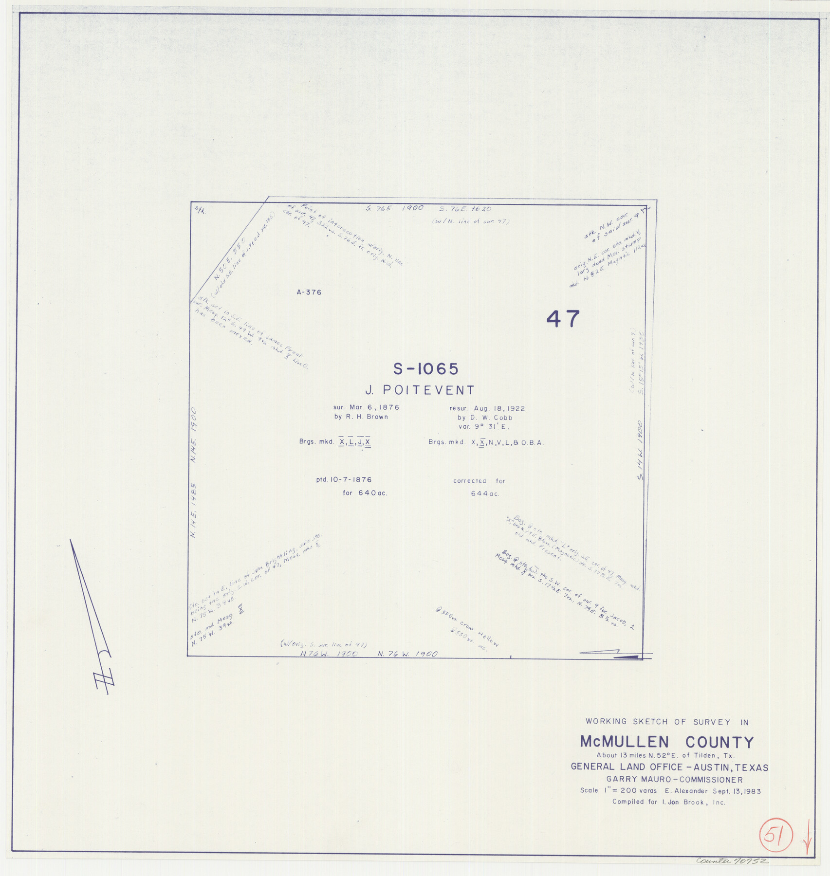
McMullen County Working Sketch 51
-
Map/Doc
70752
-
Collection
General Map Collection
-
Object Dates
9/13/1983 (Creation Date)
-
Counties
McMullen
-
Subjects
Surveying Working Sketch
-
Height x Width
18.3 x 17.4 inches
46.5 x 44.2 cm
-
Scale
1" = 200 varas
Part of: General Map Collection
Texas Intracoastal Waterway - Port O'Connor to San Antonio Bay, Including Pass Cavallo

Print $20.00
- Digital $50.00
Texas Intracoastal Waterway - Port O'Connor to San Antonio Bay, Including Pass Cavallo
1957
Size 28.1 x 40.0 inches
Map/Doc 73372
Map of the State of Texas

Print $40.00
- Digital $50.00
Map of the State of Texas
1879
Size 102.7 x 57.6 inches
Map/Doc 93383
Hall County Rolled Sketch 8

Print $20.00
- Digital $50.00
Hall County Rolled Sketch 8
1942
Size 24.7 x 41.6 inches
Map/Doc 6052
Webb County Rolled Sketch 33

Print $20.00
- Digital $50.00
Webb County Rolled Sketch 33
1939
Size 22.8 x 23.9 inches
Map/Doc 8189
Gillespie County Working Sketch 1

Print $20.00
- Digital $50.00
Gillespie County Working Sketch 1
1950
Size 23.9 x 18.7 inches
Map/Doc 63164
Harris County State Real Property Sketch 5

Print $20.00
- Digital $50.00
Harris County State Real Property Sketch 5
2003
Size 24.5 x 36.0 inches
Map/Doc 82007
Flight Mission No. DIX-10P, Frame 147, Aransas County

Print $20.00
- Digital $50.00
Flight Mission No. DIX-10P, Frame 147, Aransas County
1956
Size 18.7 x 22.4 inches
Map/Doc 83949
Flight Mission No. CUG-1P, Frame 80, Kleberg County

Print $20.00
- Digital $50.00
Flight Mission No. CUG-1P, Frame 80, Kleberg County
1956
Size 18.8 x 22.4 inches
Map/Doc 86145
Collin County Boundary File 18 and 18a

Print $8.00
- Digital $50.00
Collin County Boundary File 18 and 18a
Size 7.8 x 4.0 inches
Map/Doc 51717
Kendall County Working Sketch 20

Print $20.00
- Digital $50.00
Kendall County Working Sketch 20
1970
Size 37.7 x 44.8 inches
Map/Doc 66692
Flight Mission No. BRE-3P, Frame 78, Nueces County

Print $20.00
- Digital $50.00
Flight Mission No. BRE-3P, Frame 78, Nueces County
1956
Size 18.5 x 22.2 inches
Map/Doc 86819
Kimble County Working Sketch 91

Print $20.00
- Digital $50.00
Kimble County Working Sketch 91
1979
Size 26.8 x 25.5 inches
Map/Doc 70159
You may also like
[Sketch for Mineral Application 16787 - Pecos River Bed, A. T. Freet]
![2815, [Sketch for Mineral Application 16787 - Pecos River Bed, A. T. Freet], General Map Collection](https://historictexasmaps.com/wmedia_w700/maps/2815-1.tif.jpg)
Print $20.00
- Digital $50.00
[Sketch for Mineral Application 16787 - Pecos River Bed, A. T. Freet]
1927
Size 20.0 x 46.7 inches
Map/Doc 2815
Atascosa County Rolled Sketch 22

Print $40.00
- Digital $50.00
Atascosa County Rolled Sketch 22
1917
Size 26.1 x 57.2 inches
Map/Doc 8918
Flight Mission No. CRC-3R, Frame 32, Chambers County

Print $20.00
- Digital $50.00
Flight Mission No. CRC-3R, Frame 32, Chambers County
1956
Size 18.6 x 22.3 inches
Map/Doc 84805
Winkler County Working Sketch 18

Print $40.00
- Digital $50.00
Winkler County Working Sketch 18
1980
Size 33.7 x 49.9 inches
Map/Doc 72612
General Highway Map. Detail of Cities and Towns in Dallas County, Texas [Dallas and vicinity]
![79067, General Highway Map. Detail of Cities and Towns in Dallas County, Texas [Dallas and vicinity], Texas State Library and Archives](https://historictexasmaps.com/wmedia_w700/maps/79067.tif.jpg)
Print $20.00
General Highway Map. Detail of Cities and Towns in Dallas County, Texas [Dallas and vicinity]
1936
Size 18.3 x 25.1 inches
Map/Doc 79067
Lampasas County Boundary File 6

Print $40.00
- Digital $50.00
Lampasas County Boundary File 6
Size 9.1 x 7.8 inches
Map/Doc 56136
Nueces County Sketch File 55

Print $16.00
- Digital $50.00
Nueces County Sketch File 55
1999
Size 11.3 x 8.8 inches
Map/Doc 32867
Map of Aransas Co.

Print $20.00
- Digital $50.00
Map of Aransas Co.
1896
Size 38.8 x 36.8 inches
Map/Doc 4874
[Location Survey of the Southern Kansas Railway, Kiowa Extension from a point in Drake's Location, in Indian Territory 100 miles from south line of Kansas, continuing up Wolf Creek and South Canadian River to Cottonwood Creek in Hutchinson County]
![88841, [Location Survey of the Southern Kansas Railway, Kiowa Extension from a point in Drake's Location, in Indian Territory 100 miles from south line of Kansas, continuing up Wolf Creek and South Canadian River to Cottonwood Creek in Hutchinson County], General Map Collection](https://historictexasmaps.com/wmedia_w700/maps/88841.tif.jpg)
Print $20.00
- Digital $50.00
[Location Survey of the Southern Kansas Railway, Kiowa Extension from a point in Drake's Location, in Indian Territory 100 miles from south line of Kansas, continuing up Wolf Creek and South Canadian River to Cottonwood Creek in Hutchinson County]
1886
Size 39.1 x 42.0 inches
Map/Doc 88841
Comanche County Working Sketch 29

Print $20.00
- Digital $50.00
Comanche County Working Sketch 29
1986
Size 29.3 x 37.8 inches
Map/Doc 68163
Upton County Working Sketch 19

Print $40.00
- Digital $50.00
Upton County Working Sketch 19
1949
Size 51.7 x 43.3 inches
Map/Doc 69515
Reagan County Sketch File 27

Print $8.00
- Digital $50.00
Reagan County Sketch File 27
1949
Size 11.4 x 8.7 inches
Map/Doc 35021