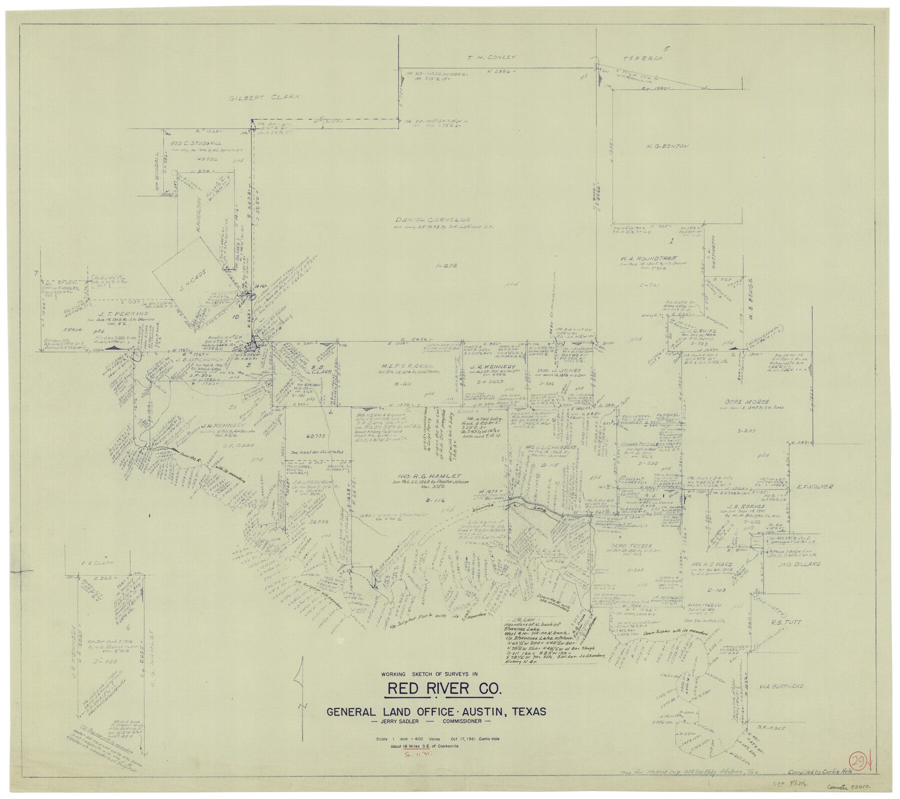
Red River County Working Sketch 29
-
Map/Doc
72012
-
Collection
General Map Collection
-
Object Dates
10/17/1961 (Creation Date)
-
People and Organizations
Curtis R. Hale (Draftsman)
-
Counties
Red River
-
Subjects
Surveying Working Sketch
-
Height x Width
29.5 x 33.3 inches
74.9 x 84.6 cm
-
Scale
1" = 400 varas
Part of: General Map Collection
Grimes County Working Sketch 14

Print $20.00
- Digital $50.00
Grimes County Working Sketch 14
1983
Size 33.0 x 34.1 inches
Map/Doc 63305
Upshur County Sketch File 5

Print $4.00
- Digital $50.00
Upshur County Sketch File 5
1855
Size 8.3 x 12.9 inches
Map/Doc 38740

Wheeler County Sketch File 11

Print $47.00
- Digital $50.00
Wheeler County Sketch File 11
1992
Size 11.5 x 9.0 inches
Map/Doc 40014
Texas, Aransas Bay, Aransas Pass to Nine Mile Point

Print $40.00
- Digital $50.00
Texas, Aransas Bay, Aransas Pass to Nine Mile Point
1934
Size 35.2 x 48.4 inches
Map/Doc 73431
United States Bathymetric and Fishing Maps including Topographic/Bathymetric Maps

Print $40.00
- Digital $50.00
United States Bathymetric and Fishing Maps including Topographic/Bathymetric Maps
1992
Size 21.5 x 54.9 inches
Map/Doc 76128
Hale County Sketch File D

Print $40.00
- Digital $50.00
Hale County Sketch File D
1901
Size 16.5 x 12.2 inches
Map/Doc 24721
Ector County Working Sketch Graphic Index - sheet B

Print $20.00
- Digital $50.00
Ector County Working Sketch Graphic Index - sheet B
1943
Size 43.9 x 37.7 inches
Map/Doc 76531
Val Verde County Rolled Sketch 79

Print $20.00
- Digital $50.00
Val Verde County Rolled Sketch 79
1983
Size 25.6 x 21.7 inches
Map/Doc 8141
Rusk County Working Sketch 34

Print $20.00
- Digital $50.00
Rusk County Working Sketch 34
1994
Size 43.5 x 33.1 inches
Map/Doc 63671
Map of Nacogdoches County

Print $20.00
- Digital $50.00
Map of Nacogdoches County
1846
Size 43.9 x 39.7 inches
Map/Doc 87356
Flight Mission No. BRE-2P, Frame 15, Nueces County

Print $20.00
- Digital $50.00
Flight Mission No. BRE-2P, Frame 15, Nueces County
1956
Size 18.4 x 22.4 inches
Map/Doc 86724
You may also like
[Located Line of the Panhandle & Gulf Ry. through State Lands]
![64103, [Located Line of the Panhandle & Gulf Ry. through State Lands], General Map Collection](https://historictexasmaps.com/wmedia_w700/maps/64103.tif.jpg)
Print $40.00
- Digital $50.00
[Located Line of the Panhandle & Gulf Ry. through State Lands]
1904
Size 12.4 x 121.6 inches
Map/Doc 64103
The Republic County of Lamar. Spring 1842

Print $20.00
The Republic County of Lamar. Spring 1842
2020
Size 16.4 x 21.7 inches
Map/Doc 96204
Gaines County Working Sketch Graphic Index

Print $40.00
- Digital $50.00
Gaines County Working Sketch Graphic Index
1956
Size 42.7 x 54.0 inches
Map/Doc 76550
Northeast Part Pecos County

Print $20.00
- Digital $50.00
Northeast Part Pecos County
1975
Size 35.8 x 42.3 inches
Map/Doc 73260
Flight Mission No. DIX-10P, Frame 71, Aransas County

Print $20.00
- Digital $50.00
Flight Mission No. DIX-10P, Frame 71, Aransas County
1956
Size 18.6 x 22.3 inches
Map/Doc 83932
Angelina County Working Sketch 38

Print $20.00
- Digital $50.00
Angelina County Working Sketch 38
1958
Size 26.4 x 33.0 inches
Map/Doc 67121
Brewster County Sketch File NS-6

Print $40.00
- Digital $50.00
Brewster County Sketch File NS-6
1944
Size 31.8 x 18.6 inches
Map/Doc 10989
Hockley County Sketch File 3

Print $20.00
- Digital $50.00
Hockley County Sketch File 3
Size 43.1 x 35.4 inches
Map/Doc 10490
City of San Antonio, Texas

Print $20.00
City of San Antonio, Texas
1889
Size 34.2 x 34.1 inches
Map/Doc 76187
Zavalla County

Print $20.00
- Digital $50.00
Zavalla County
1879
Size 21.2 x 25.4 inches
Map/Doc 4183

El Paso County Working Sketch 59

Print $20.00
- Digital $50.00
El Paso County Working Sketch 59
2000
Size 28.1 x 35.7 inches
Map/Doc 69081