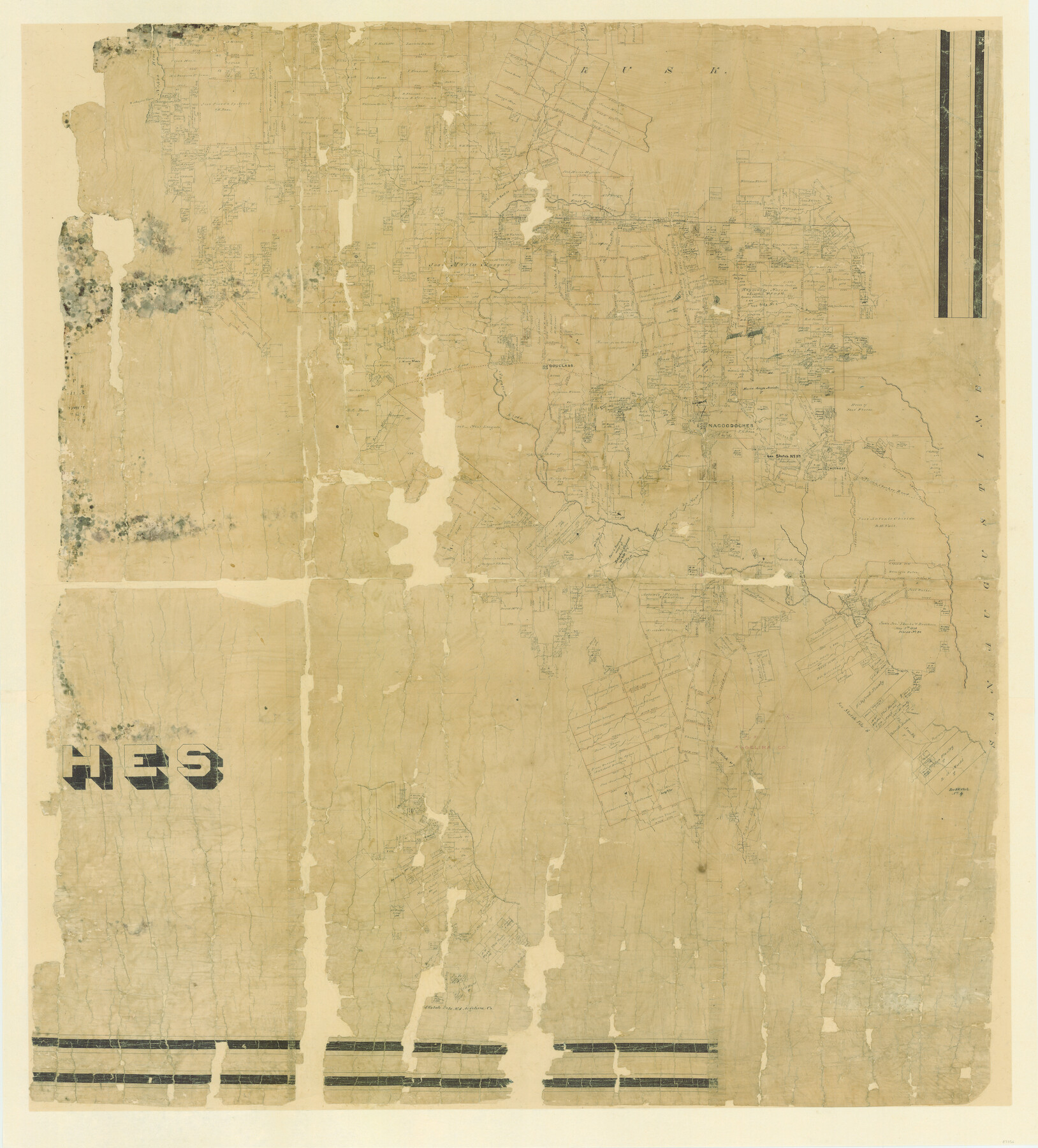
Map of Nacogdoches County
-
Map/Doc
87356
-
Collection
General Map Collection
-
Object Dates
1846 (Creation Date)
-
People and Organizations
H.L. Upshur (Draftsman)
A.A. Nelson (Surveyor/Engineer)
-
Counties
Nacogdoches
-
Subjects
County
-
Height x Width
43.9 x 39.7 inches
111.5 x 100.8 cm
-
Comments
Adopted in 2006 in Memory of Charles Wallace Pratt by loved ones and conservation funded in 2007.
Digital composition of counter numbers 87355, 87356, 87357 and 87358.
Prints made at 65%.
Related maps
Map of Nacogdoches County

Print $20.00
- Digital $50.00
Map of Nacogdoches County
1846
Size 44.7 x 40.0 inches
Map/Doc 87355
Map of Nacogdoches County

Print $20.00
- Digital $50.00
Map of Nacogdoches County
1846
Size 43.8 x 39.2 inches
Map/Doc 87357
Map of Nacogdoches County

Print $20.00
- Digital $50.00
Map of Nacogdoches County
1846
Size 42.7 x 40.0 inches
Map/Doc 87358
Part of: General Map Collection
Louisiana and Texas Intracoastal Waterway, Section 7, Galveston Bay to Brazos River and Section 8, Brazos River to Matagorda Bay

Print $20.00
- Digital $50.00
Louisiana and Texas Intracoastal Waterway, Section 7, Galveston Bay to Brazos River and Section 8, Brazos River to Matagorda Bay
1937
Size 31.0 x 42.8 inches
Map/Doc 61843
Atascosa County Working Sketch 21

Print $20.00
- Digital $50.00
Atascosa County Working Sketch 21
1954
Size 26.0 x 22.4 inches
Map/Doc 67217
Rockwall County

Print $20.00
- Digital $50.00
Rockwall County
1874
Size 20.3 x 18.6 inches
Map/Doc 3998
Scurry County Working Sketch 10

Print $20.00
- Digital $50.00
Scurry County Working Sketch 10
1990
Size 25.7 x 28.7 inches
Map/Doc 63839
Bastrop County Boundary File 2

Print $12.00
- Digital $50.00
Bastrop County Boundary File 2
Size 9.1 x 6.9 inches
Map/Doc 50315
Randall County Sketch File 2

Print $4.00
- Digital $50.00
Randall County Sketch File 2
1913
Size 7.3 x 8.8 inches
Map/Doc 34961
Harris County Working Sketch 54

Print $20.00
- Digital $50.00
Harris County Working Sketch 54
1950
Size 21.3 x 24.1 inches
Map/Doc 65946
Flight Mission No. BRE-1P, Frame 144, Nueces County

Print $20.00
- Digital $50.00
Flight Mission No. BRE-1P, Frame 144, Nueces County
1956
Size 18.3 x 22.3 inches
Map/Doc 86704
Right of Way & Track Map, St. Louis, Brownsville & Mexico Ry. operated by St. Louis, Brownsville & Mexico Ry. Co.

Print $40.00
- Digital $50.00
Right of Way & Track Map, St. Louis, Brownsville & Mexico Ry. operated by St. Louis, Brownsville & Mexico Ry. Co.
1919
Size 25.4 x 56.9 inches
Map/Doc 64614
Gray County Sketch File A

Print $20.00
- Digital $50.00
Gray County Sketch File A
1889
Size 14.2 x 14.6 inches
Map/Doc 24456
Flight Mission No. CUG-3P, Frame 91, Kleberg County

Print $20.00
- Digital $50.00
Flight Mission No. CUG-3P, Frame 91, Kleberg County
1956
Size 18.4 x 22.2 inches
Map/Doc 86261

You may also like
Bobalet Heights

Print $20.00
- Digital $50.00
Bobalet Heights
1941
Size 35.6 x 36.5 inches
Map/Doc 92787
[Sketch showing Potter County Block 2] / [Sketch showing F. W. & D. C. Round House]
![91710, [Sketch showing Potter County Block 2] / [Sketch showing F. W. & D. C. Round House], Twichell Survey Records](https://historictexasmaps.com/wmedia_w700/maps/91710-1.tif.jpg)
Print $20.00
- Digital $50.00
[Sketch showing Potter County Block 2] / [Sketch showing F. W. & D. C. Round House]
Size 14.6 x 12.1 inches
Map/Doc 91710
Montgomery County Working Sketch 69

Print $20.00
- Digital $50.00
Montgomery County Working Sketch 69
1973
Size 27.3 x 37.7 inches
Map/Doc 71176
Live Oak County Sketch File 3

Print $22.00
- Digital $50.00
Live Oak County Sketch File 3
1848
Size 12.6 x 16.1 inches
Map/Doc 30255
Hudspeth County Working Sketch 50

Print $20.00
- Digital $50.00
Hudspeth County Working Sketch 50
Size 24.6 x 37.2 inches
Map/Doc 66335
[B. S. & F. Block 9 and surrounding area]
![93070, [B. S. & F. Block 9 and surrounding area], Twichell Survey Records](https://historictexasmaps.com/wmedia_w700/maps/93070-1.tif.jpg)
Print $20.00
- Digital $50.00
[B. S. & F. Block 9 and surrounding area]
Size 18.3 x 26.1 inches
Map/Doc 93070
Webb County Working Sketch 22

Print $20.00
- Digital $50.00
Webb County Working Sketch 22
1926
Size 22.7 x 20.8 inches
Map/Doc 72387
Menard County Sketch File 12

Print $12.00
- Digital $50.00
Menard County Sketch File 12
1892
Size 11.1 x 8.2 inches
Map/Doc 31500
Coleman County Working Sketch 23

Print $20.00
- Digital $50.00
Coleman County Working Sketch 23
1958
Size 30.4 x 29.5 inches
Map/Doc 68276
Maverick County Sketch File 26

Print $14.00
- Digital $50.00
Maverick County Sketch File 26
1955
Size 11.3 x 8.7 inches
Map/Doc 31153
Nueces County Sketch File 82

Print $4.00
- Digital $50.00
Nueces County Sketch File 82
2000
Size 11.0 x 8.8 inches
Map/Doc 33165
Henderson County Rolled Sketch 11

Print $20.00
- Digital $50.00
Henderson County Rolled Sketch 11
1915
Size 29.2 x 41.6 inches
Map/Doc 76147