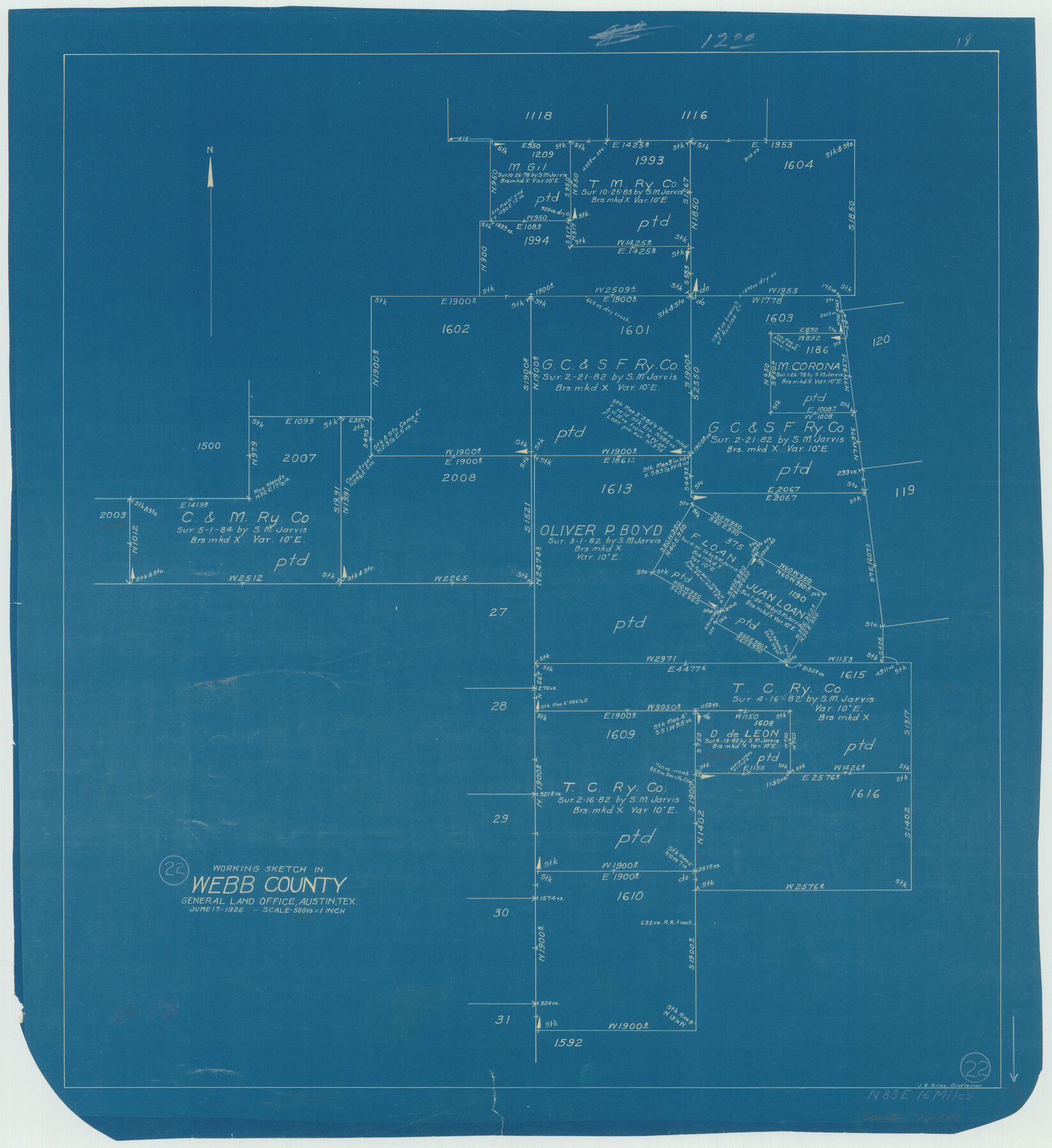
Webb County Working Sketch 22
-
Map/Doc
72387
-
Collection
General Map Collection
-
Object Dates
6/17/1926 (Creation Date)
-
People and Organizations
J. Bascom Giles (Draftsman)
-
Counties
Webb
-
Subjects
Surveying Working Sketch
-
Height x Width
22.7 x 20.8 inches
57.7 x 52.8 cm
-
Scale
1" = 500 varas
Part of: General Map Collection
Map of Webb County

Print $20.00
- Digital $50.00
Map of Webb County
1888
Size 33.6 x 27.7 inches
Map/Doc 4128
Flight Mission No. BRA-7M, Frame 206, Jefferson County

Print $20.00
- Digital $50.00
Flight Mission No. BRA-7M, Frame 206, Jefferson County
1953
Size 18.6 x 22.2 inches
Map/Doc 85574
The United States and the Relative Position of the Oregon and Texas

Print $20.00
- Digital $50.00
The United States and the Relative Position of the Oregon and Texas
1850
Size 16.8 x 23.1 inches
Map/Doc 93666
Hudspeth County Rolled Sketch 46

Print $40.00
- Digital $50.00
Hudspeth County Rolled Sketch 46
Size 10.6 x 123.7 inches
Map/Doc 9221
Limestone County Working Sketch 23

Print $20.00
- Digital $50.00
Limestone County Working Sketch 23
1980
Size 37.3 x 37.5 inches
Map/Doc 70573
Reagan County Sketch File 34

Print $4.00
- Digital $50.00
Reagan County Sketch File 34
Size 11.5 x 8.9 inches
Map/Doc 35030
Cherokee County Working Sketch 22

Print $20.00
- Digital $50.00
Cherokee County Working Sketch 22
1972
Size 24.0 x 19.2 inches
Map/Doc 67977
Flight Mission No. CGI-3N, Frame 173, Cameron County

Print $20.00
- Digital $50.00
Flight Mission No. CGI-3N, Frame 173, Cameron County
1954
Size 18.5 x 22.3 inches
Map/Doc 84637
Map of Liberty County

Print $40.00
- Digital $50.00
Map of Liberty County
1903
Size 54.9 x 53.6 inches
Map/Doc 16878
Surveys on the Coleto Creek, Goliad County

Print $20.00
- Digital $50.00
Surveys on the Coleto Creek, Goliad County
1841
Size 13.8 x 14.9 inches
Map/Doc 10
Kendall County

Print $20.00
- Digital $50.00
Kendall County
1946
Size 41.1 x 35.3 inches
Map/Doc 77336
Kendall County Sketch File 22

Print $20.00
- Digital $50.00
Kendall County Sketch File 22
1926
Size 17.0 x 25.8 inches
Map/Doc 11910
You may also like
Haskell County Sketch File 10

Print $8.00
- Digital $50.00
Haskell County Sketch File 10
Size 13.0 x 8.2 inches
Map/Doc 26136
Fisher County Working Sketch 1

Print $20.00
- Digital $50.00
Fisher County Working Sketch 1
1911
Size 37.6 x 26.4 inches
Map/Doc 69135
Denison, Texas, Grayson County 1886

Print $20.00
Denison, Texas, Grayson County 1886
1886
Size 21.1 x 30.5 inches
Map/Doc 93466
King County Sketch File 8

Print $46.00
- Digital $50.00
King County Sketch File 8
Size 8.8 x 8.9 inches
Map/Doc 29060
Rockwall County Working Sketch 2

Print $20.00
- Digital $50.00
Rockwall County Working Sketch 2
1923
Size 20.9 x 16.8 inches
Map/Doc 63594
PSL Field Notes for Blocks G, L, P, and Q in Cochran and Yoakum Counties and Blocks U, V, W, Y, and Z in Cochran County

PSL Field Notes for Blocks G, L, P, and Q in Cochran and Yoakum Counties and Blocks U, V, W, Y, and Z in Cochran County
Map/Doc 81645
Enochs Land situated in Bailey and Cochran Counties, Texas

Print $20.00
- Digital $50.00
Enochs Land situated in Bailey and Cochran Counties, Texas
Size 28.9 x 35.6 inches
Map/Doc 90194
Brewster County Working Sketch 49

Print $20.00
- Digital $50.00
Brewster County Working Sketch 49
1949
Size 37.1 x 22.6 inches
Map/Doc 67583
University Lands Blocks 21 to 26, Pecos County, Texas

Print $20.00
- Digital $50.00
University Lands Blocks 21 to 26, Pecos County, Texas
1939
Size 46.1 x 36.8 inches
Map/Doc 2416
Flight Mission No. CGI-3N, Frame 184, Cameron County

Print $20.00
- Digital $50.00
Flight Mission No. CGI-3N, Frame 184, Cameron County
1954
Size 18.5 x 22.3 inches
Map/Doc 84648
Dimmit County Working Sketch 35

Print $20.00
- Digital $50.00
Dimmit County Working Sketch 35
1961
Size 22.4 x 24.4 inches
Map/Doc 68696
Henderson County Working Sketch 13

Print $20.00
- Digital $50.00
Henderson County Working Sketch 13
1918
Size 23.2 x 24.7 inches
Map/Doc 66146