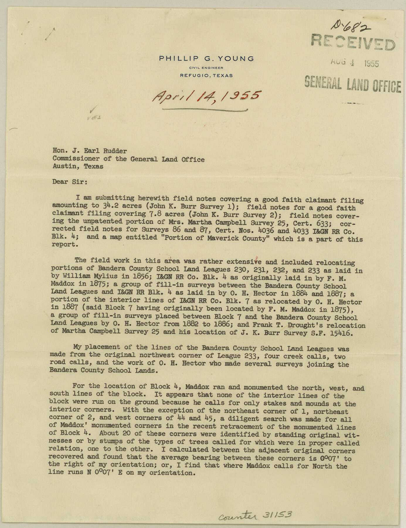
Maverick County Sketch File 26
[Surveyor's report of a resurvey of Bandera County School Land surveys no. 231, 232, and 233 and parts of I. & G. N. R.R. Co. Blocks 4 and 7]
-
Map/Doc
31153
-
Collection
General Map Collection
-
Object Dates
4/14/1955 (Creation Date)
8/4/1955 (File Date)
-
People and Organizations
Phillip G. Young (Surveyor/Engineer)
-
Counties
Maverick
-
Subjects
Surveying Sketch File
-
Height x Width
11.3 x 8.7 inches
28.7 x 22.1 cm
-
Medium
paper, print
-
Comments
See Maverick County Rolled Sketch 19 (9494) for sketch.
-
Features
Eagle Pass Road
Saus Creek
Related maps
Maverick County Rolled Sketch 19

Print $20.00
- Digital $50.00
Maverick County Rolled Sketch 19
1955
Size 33.5 x 44.1 inches
Map/Doc 9494
Part of: General Map Collection
Jasper County Sketch File 33

Print $20.00
- Digital $50.00
Jasper County Sketch File 33
1938
Size 23.0 x 17.6 inches
Map/Doc 11854
Calhoun County NRC Article 33.136 Sketch 11

Digital $50.00
Calhoun County NRC Article 33.136 Sketch 11
2023
Map/Doc 97255
Map and Profile of the Denison and Pacific Railway from Denison to Whitesboro

Print $40.00
- Digital $50.00
Map and Profile of the Denison and Pacific Railway from Denison to Whitesboro
1878
Size 42.5 x 57.5 inches
Map/Doc 64284
Galveston County Aerial Photograph Index Sheet 1

Print $20.00
- Digital $50.00
Galveston County Aerial Photograph Index Sheet 1
1953
Size 23.4 x 19.2 inches
Map/Doc 83692
Harris County Working Sketch 50

Print $20.00
- Digital $50.00
Harris County Working Sketch 50
1947
Size 38.7 x 35.6 inches
Map/Doc 65942
Township 3 North Range 14 West, North Western District, Louisiana

Print $20.00
- Digital $50.00
Township 3 North Range 14 West, North Western District, Louisiana
1844
Size 19.8 x 24.7 inches
Map/Doc 65862
[Sketch for Mineral Application 33721 - 33725 Incl. - Padre and Mustang Island]
![2874, [Sketch for Mineral Application 33721 - 33725 Incl. - Padre and Mustang Island], General Map Collection](https://historictexasmaps.com/wmedia_w700/maps/2874.tif.jpg)
Print $20.00
- Digital $50.00
[Sketch for Mineral Application 33721 - 33725 Incl. - Padre and Mustang Island]
1941
Size 40.2 x 22.8 inches
Map/Doc 2874
Kent County Sketch File 13

Print $6.00
- Digital $50.00
Kent County Sketch File 13
1921
Size 11.1 x 8.7 inches
Map/Doc 28839
Presidio County Working Sketch 5

Print $20.00
- Digital $50.00
Presidio County Working Sketch 5
1917
Size 14.0 x 17.5 inches
Map/Doc 71679
Reagan County Rolled Sketch 20

Print $20.00
- Digital $50.00
Reagan County Rolled Sketch 20
1948
Size 45.8 x 45.0 inches
Map/Doc 9814
Hudspeth County Rolled Sketch 17

Print $40.00
- Digital $50.00
Hudspeth County Rolled Sketch 17
1886
Size 22.3 x 118.5 inches
Map/Doc 9203
Brooks County Working Sketch 3

Print $20.00
- Digital $50.00
Brooks County Working Sketch 3
Size 16.2 x 21.3 inches
Map/Doc 67787
You may also like
Culberson County Working Sketch 30

Print $20.00
- Digital $50.00
Culberson County Working Sketch 30
1958
Size 29.3 x 30.2 inches
Map/Doc 68483
La Salle County Rolled Sketch 34

Print $20.00
- Digital $50.00
La Salle County Rolled Sketch 34
2019
Size 22.3 x 35.5 inches
Map/Doc 95702
Brewster County Sketch File 14

Print $26.00
- Digital $50.00
Brewster County Sketch File 14
Size 11.2 x 8.8 inches
Map/Doc 15746
Kleberg County

Print $20.00
- Digital $50.00
Kleberg County
1913
Size 27.0 x 33.9 inches
Map/Doc 95560
Andrews County Sketch File 4

Print $40.00
- Digital $50.00
Andrews County Sketch File 4
1930
Size 18.5 x 24.2 inches
Map/Doc 10809
[Township 3 North, Block 34]
![91227, [Township 3 North, Block 34], Twichell Survey Records](https://historictexasmaps.com/wmedia_w700/maps/91227-1.tif.jpg)
Print $2.00
- Digital $50.00
[Township 3 North, Block 34]
Size 9.2 x 11.7 inches
Map/Doc 91227
Rains County Rolled Sketch 1

Print $40.00
- Digital $50.00
Rains County Rolled Sketch 1
1958
Size 42.0 x 65.2 inches
Map/Doc 9806
[Morris County School Land and vicinity]
![90360, [Morris County School Land and vicinity], Twichell Survey Records](https://historictexasmaps.com/wmedia_w700/maps/90360-1.tif.jpg)
Print $20.00
- Digital $50.00
[Morris County School Land and vicinity]
Size 14.2 x 13.0 inches
Map/Doc 90360
Jackson County Rolled Sketch 12

Print $20.00
- Digital $50.00
Jackson County Rolled Sketch 12
1956
Size 23.9 x 32.7 inches
Map/Doc 6344
Pecos County Rolled Sketch 19

Print $21.00
- Digital $50.00
Pecos County Rolled Sketch 19
1885
Size 9.4 x 14.7 inches
Map/Doc 48082
Harris County Sketch File 101

Print $104.00
- Digital $50.00
Harris County Sketch File 101
1991
Size 11.3 x 8.9 inches
Map/Doc 25873
Hudspeth County Working Sketch 24

Print $40.00
- Digital $50.00
Hudspeth County Working Sketch 24
1967
Size 46.0 x 54.9 inches
Map/Doc 66306