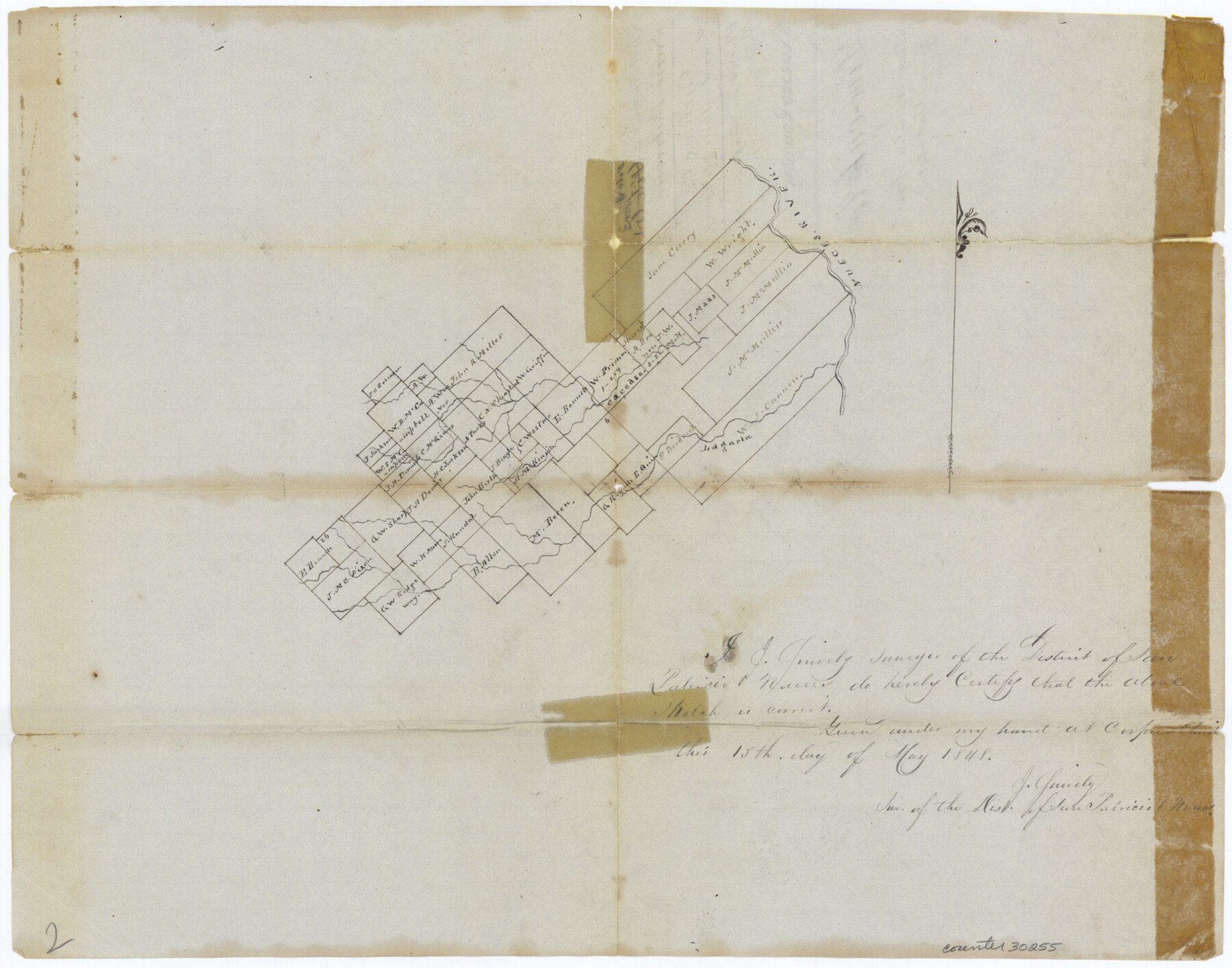
Live Oak County Sketch File 3
[Sketch southeast of Oakville]
-
Map/Doc
30255
-
Collection
General Map Collection
-
Object Dates
6/26/1848 (File Date)
5/13/1848 (Creation Date)
-
People and Organizations
J. Snively (Surveyor/Engineer)
-
Counties
Live Oak Jim Wells
-
Subjects
Surveying Sketch File
-
Height x Width
12.6 x 16.1 inches
32.0 x 40.9 cm
-
Medium
paper, manuscript
-
Features
Nueces River
Carrease Creek
Lagarla Creek
Part of: General Map Collection


San Saba County

Print $20.00
- Digital $50.00
San Saba County
1877
Size 20.2 x 22.0 inches
Map/Doc 4020
Panola County Sketch File 27

Print $8.00
- Digital $50.00
Panola County Sketch File 27
1850
Size 5.4 x 7.7 inches
Map/Doc 33498
Cottle County Working Sketch 8

Print $20.00
- Digital $50.00
Cottle County Working Sketch 8
1917
Size 26.9 x 29.7 inches
Map/Doc 68318
Hudspeth County Rolled Sketch 19

Print $20.00
- Digital $50.00
Hudspeth County Rolled Sketch 19
Size 47.8 x 44.6 inches
Map/Doc 9205
Fractional Township No. 8 South Range No. 4 East of the Indian Meridian, Indian Territory

Print $20.00
- Digital $50.00
Fractional Township No. 8 South Range No. 4 East of the Indian Meridian, Indian Territory
1898
Size 19.2 x 24.4 inches
Map/Doc 75208
Lavaca County Working Sketch 14

Print $20.00
- Digital $50.00
Lavaca County Working Sketch 14
1962
Size 28.4 x 29.7 inches
Map/Doc 70367
Harris County Working Sketch 115

Print $40.00
- Digital $50.00
Harris County Working Sketch 115
1983
Size 48.8 x 44.5 inches
Map/Doc 66007

Duval County Sketch File 4a

Print $6.00
- Digital $50.00
Duval County Sketch File 4a
1875
Size 13.3 x 10.8 inches
Map/Doc 21280
Chambers County NRC Article 33.136 Sketch 5

Print $22.00
- Digital $50.00
Chambers County NRC Article 33.136 Sketch 5
2003
Size 24.2 x 18.3 inches
Map/Doc 78608
You may also like
Brown County Sketch File 2

Print $4.00
- Digital $50.00
Brown County Sketch File 2
Size 11.8 x 8.1 inches
Map/Doc 16582
Collin County

Print $20.00
- Digital $50.00
Collin County
1975
Size 42.2 x 39.4 inches
Map/Doc 77242
Kenedy County Rolled Sketch 10

Print $20.00
- Digital $50.00
Kenedy County Rolled Sketch 10
1915
Size 21.7 x 35.7 inches
Map/Doc 6470

Map of Briscoe County, Texas

Print $20.00
- Digital $50.00
Map of Briscoe County, Texas
1879
Size 22.6 x 18.0 inches
Map/Doc 614
Millennium in Maps - Exploration

Millennium in Maps - Exploration
Size 20.6 x 31.5 inches
Map/Doc 95931
[W. T. Brewer: M. McDonald, Ralph Gilpin, A. Vanhooser, John Baker, John R. Taylor Surveys]
![90957, [W. T. Brewer: M. McDonald, Ralph Gilpin, A. Vanhooser, John Baker, John R. Taylor Surveys], Twichell Survey Records](https://historictexasmaps.com/wmedia_w700/maps/90957-1.tif.jpg)
Print $2.00
- Digital $50.00
[W. T. Brewer: M. McDonald, Ralph Gilpin, A. Vanhooser, John Baker, John R. Taylor Surveys]
Size 8.7 x 11.3 inches
Map/Doc 90957
General Highway Map, Kenedy County, Texas

Print $20.00
General Highway Map, Kenedy County, Texas
1940
Size 18.5 x 24.9 inches
Map/Doc 79154

Bee County Sketch File 29

Print $6.00
- Digital $50.00
Bee County Sketch File 29
1887
Size 14.0 x 8.8 inches
Map/Doc 14338
[Leagues 7, 8, 9, and 10]
![92219, [Leagues 7, 8, 9, and 10], Twichell Survey Records](https://historictexasmaps.com/wmedia_w700/maps/92219-1.tif.jpg)
Print $20.00
- Digital $50.00
[Leagues 7, 8, 9, and 10]
1943
Size 20.6 x 12.5 inches
Map/Doc 92219
[Township 3 North, Block 33]
![91214, [Township 3 North, Block 33], Twichell Survey Records](https://historictexasmaps.com/wmedia_w700/maps/91214-1.tif.jpg)
Print $3.00
- Digital $50.00
[Township 3 North, Block 33]
Size 11.0 x 11.3 inches
Map/Doc 91214