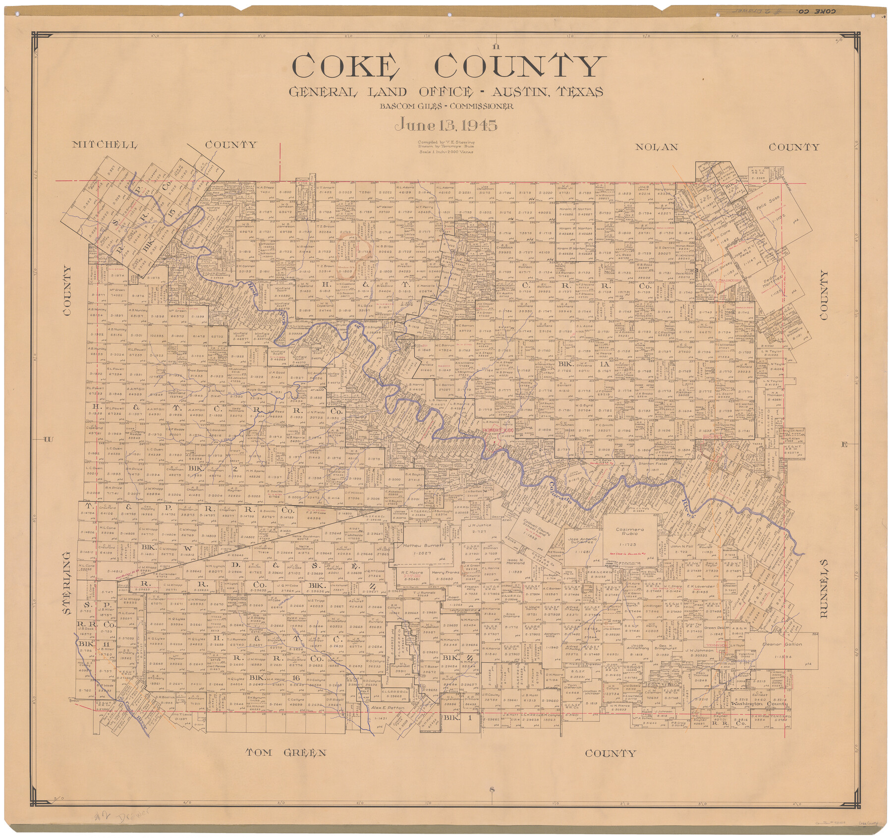
Coke County
-
Map/Doc
73108
-
Collection
General Map Collection
-
Object Dates
1945/6/13 (Creation Date)
-
People and Organizations
Texas General Land Office (Publisher)
Bascom Giles (GLO Commissioner)
Tommye Buie (Draftsman)
Victor E. Sterzing (Compiler)
-
Counties
Coke
-
Subjects
County
-
Height x Width
40.4 x 42.3 inches
102.6 x 107.4 cm
-
Comments
Hand lettered.
Note on reverse side: "Compilation completed June 13, 1945. Inking completed November 10, 1945. Tracing completed December 19, 1945. Placed in official use December 20, 1945. Replaced [on sticks] by copy August 12, 1946." -
Features
Cow Creek
Bronte
Kickapoo Creek
KCM&O
Turkey Creek
Indian Creek
Metash Creek
Colorado River
Paint Creek
South Pecan Creek
P&SF
West Grape Creek
Grape Creek
Tennyson
Gobbler Creek
Mule Creek
Concho River
Sandy Creek
Salt Creek
Robert Lee
Mountain Creek
Mess Box Creek
Yellow Wolf Creek
North Pecan Creek
Rough Creek
Red Fork
Meadow Mountain
Fort Chadbourne
Mount Wilson
Horse Creek
Holmes Creek
Gasconade Creek
Silver Creek
Part of: General Map Collection
Flight Mission No. DCL-7C, Frame 57, Kenedy County

Print $20.00
- Digital $50.00
Flight Mission No. DCL-7C, Frame 57, Kenedy County
1943
Size 15.4 x 15.2 inches
Map/Doc 86045
Brewster County Rolled Sketch 28

Print $20.00
- Digital $50.00
Brewster County Rolled Sketch 28
1910
Size 25.6 x 29.4 inches
Map/Doc 5215
Flight Mission No. CLL-1N, Frame 37, Willacy County

Print $20.00
- Digital $50.00
Flight Mission No. CLL-1N, Frame 37, Willacy County
1954
Size 18.4 x 22.0 inches
Map/Doc 87018
Flight Mission No. BRA-16M, Frame 49, Jefferson County

Print $20.00
- Digital $50.00
Flight Mission No. BRA-16M, Frame 49, Jefferson County
1953
Size 18.4 x 22.5 inches
Map/Doc 85666
Parker County Sketch File 4

Print $6.00
- Digital $50.00
Parker County Sketch File 4
1856
Size 6.2 x 5.8 inches
Map/Doc 33525
[Surveys along the Sabine River made under G.W. Smyth, Commissioner]
![90, [Surveys along the Sabine River made under G.W. Smyth, Commissioner], General Map Collection](https://historictexasmaps.com/wmedia_w700/maps/90.tif.jpg)
Print $20.00
- Digital $50.00
[Surveys along the Sabine River made under G.W. Smyth, Commissioner]
1837
Size 13.9 x 17.0 inches
Map/Doc 90
Comanche County Rolled Sketch 1

Print $20.00
- Digital $50.00
Comanche County Rolled Sketch 1
1985
Size 24.1 x 18.7 inches
Map/Doc 5542

Johnson County Sketch File 5

Print $20.00
- Digital $50.00
Johnson County Sketch File 5
1874
Size 33.3 x 14.3 inches
Map/Doc 11890
Harris County Sketch File 20a

Print $4.00
- Digital $50.00
Harris County Sketch File 20a
Size 8.8 x 14.4 inches
Map/Doc 25371
Maps of Gulf Intracoastal Waterway, Texas - Sabine River to the Rio Grande and connecting waterways including ship channels

Print $20.00
- Digital $50.00
Maps of Gulf Intracoastal Waterway, Texas - Sabine River to the Rio Grande and connecting waterways including ship channels
1966
Size 14.5 x 22.4 inches
Map/Doc 61929
Kimble County Working Sketch 89

Print $20.00
- Digital $50.00
Kimble County Working Sketch 89
1979
Size 41.2 x 33.2 inches
Map/Doc 70157
You may also like
Orange County Working Sketch 31

Print $20.00
- Digital $50.00
Orange County Working Sketch 31
1955
Size 24.2 x 13.8 inches
Map/Doc 71363
Menard County Sketch File 14

Print $4.00
- Digital $50.00
Menard County Sketch File 14
1892
Size 12.8 x 8.2 inches
Map/Doc 31508
[Sketch for Mineral Application 24072, San Jacinto River]
![65599, [Sketch for Mineral Application 24072, San Jacinto River], General Map Collection](https://historictexasmaps.com/wmedia_w700/maps/65599.tif.jpg)
Print $20.00
- Digital $50.00
[Sketch for Mineral Application 24072, San Jacinto River]
1929
Size 23.5 x 18.0 inches
Map/Doc 65599
Real County Sketch File 14

Print $20.00
- Digital $50.00
Real County Sketch File 14
1933
Size 16.5 x 16.7 inches
Map/Doc 12233
Kinney County Sketch File 31

Print $40.00
- Digital $50.00
Kinney County Sketch File 31
1934
Size 15.3 x 13.6 inches
Map/Doc 29176
Bexar County Working Sketch 5

Print $20.00
- Digital $50.00
Bexar County Working Sketch 5
1943
Size 25.3 x 25.0 inches
Map/Doc 67321
Edwards County Working Sketch 59

Print $20.00
- Digital $50.00
Edwards County Working Sketch 59
1954
Size 22.7 x 22.4 inches
Map/Doc 68935
Greater Fort Worth New City Map

Print $20.00
Greater Fort Worth New City Map
1925
Size 33.5 x 22.6 inches
Map/Doc 76286
Reagan County Working Sketch 45

Print $20.00
- Digital $50.00
Reagan County Working Sketch 45
1987
Size 30.1 x 43.1 inches
Map/Doc 71887
Crockett County Rolled Sketch 28

Print $20.00
- Digital $50.00
Crockett County Rolled Sketch 28
1884
Size 42.5 x 25.8 inches
Map/Doc 5587
Liberty County Sketch File X

Print $20.00
- Digital $50.00
Liberty County Sketch File X
Size 39.0 x 24.9 inches
Map/Doc 76769
Map of the State of Texas

Print $40.00
- Digital $50.00
Map of the State of Texas
1879
Size 102.7 x 57.6 inches
Map/Doc 93383