Menard County Sketch File 14
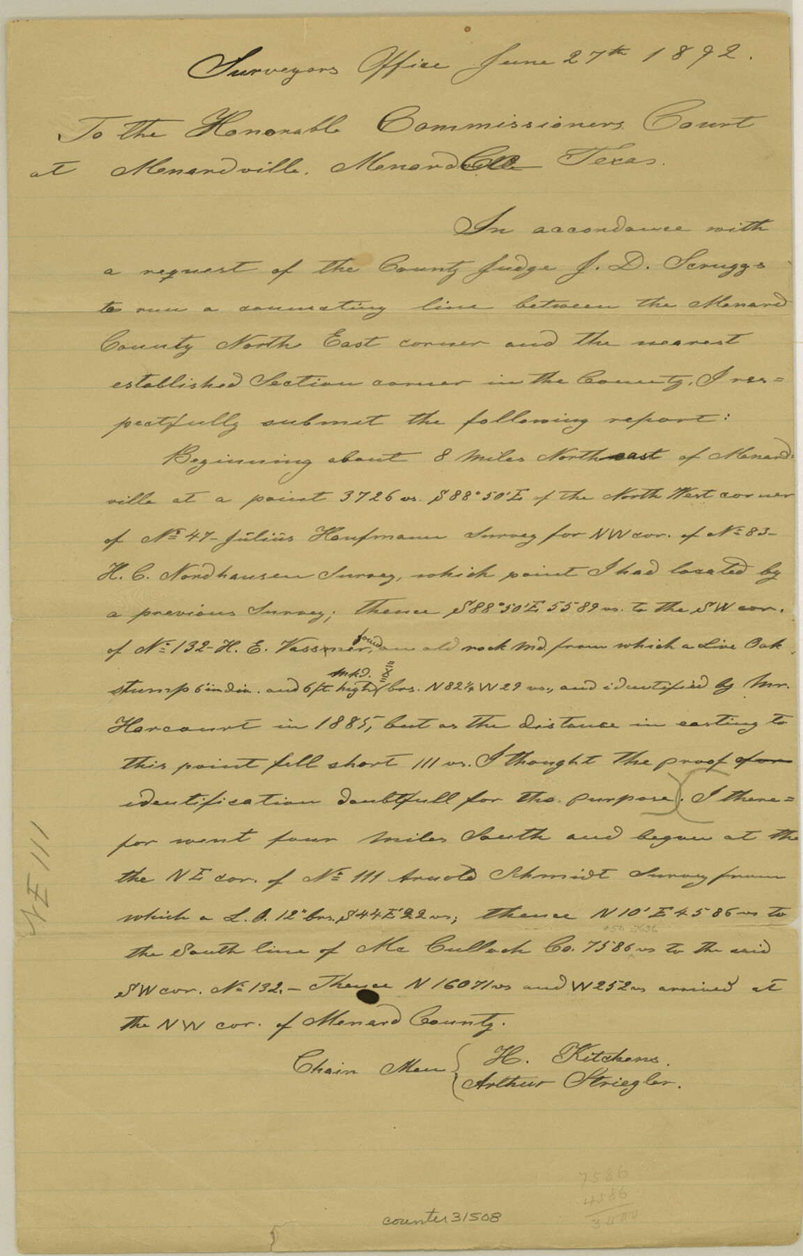
[Report on connecting line between northeast corner of Menard County and the nearest established section corner]
-
Map/Doc
31508
-
Collection
General Map Collection
-
Object Dates
6/27/1892 (Creation Date)
-
People and Organizations
Arthur Striegler (Surveyor/Engineer)
H. Kitchens (Chainman/Field Personnel)
Arthur Striegler (Chainman/Field Personnel)
-
Counties
Menard
-
Subjects
Surveying Sketch File
-
Height x Width
12.8 x 8.2 inches
32.5 x 20.8 cm
-
Medium
paper, manuscript
Part of: General Map Collection
Lee County Sketch File 5

Print $40.00
- Digital $50.00
Lee County Sketch File 5
Size 12.2 x 15.8 inches
Map/Doc 29686
Hockley County

Print $20.00
- Digital $50.00
Hockley County
1897
Size 19.1 x 20.5 inches
Map/Doc 3675

Pecos County Sketch File 27

Print $20.00
- Digital $50.00
Pecos County Sketch File 27
1900
Size 18.1 x 14.5 inches
Map/Doc 12165
Dickens County Rolled Sketch 11

Print $21.00
- Digital $50.00
Dickens County Rolled Sketch 11
1918
Size 10.6 x 15.6 inches
Map/Doc 44285
Travis County Rolled Sketch 13

Print $20.00
- Digital $50.00
Travis County Rolled Sketch 13
Size 28.0 x 20.4 inches
Map/Doc 8016
Harrison County Working Sketch 12

Print $20.00
- Digital $50.00
Harrison County Working Sketch 12
1960
Size 26.6 x 31.4 inches
Map/Doc 66032
Harris County Sketch File 18

Print $6.00
- Digital $50.00
Harris County Sketch File 18
1860
Size 8.0 x 3.4 inches
Map/Doc 25363
El Paso County Working Sketch 33

Print $20.00
- Digital $50.00
El Paso County Working Sketch 33
1974
Size 33.7 x 20.3 inches
Map/Doc 69055
Hardin County Rolled Sketch W

Print $40.00
- Digital $50.00
Hardin County Rolled Sketch W
1937
Size 48.6 x 44.4 inches
Map/Doc 9105
Hutchinson County Rolled Sketch 44-14

Print $20.00
- Digital $50.00
Hutchinson County Rolled Sketch 44-14
2002
Size 24.0 x 36.0 inches
Map/Doc 77550
Hudspeth County Rolled Sketch 69

Print $20.00
- Digital $50.00
Hudspeth County Rolled Sketch 69
1973
Size 12.2 x 20.8 inches
Map/Doc 7717
You may also like

Live Oak County

Print $40.00
- Digital $50.00
Live Oak County
1899
Size 52.1 x 37.5 inches
Map/Doc 78423
Denton County Boundary File 4 and 4a and 4b and 4c

Print $2.00
- Digital $50.00
Denton County Boundary File 4 and 4a and 4b and 4c
Size 11.0 x 8.7 inches
Map/Doc 52470
Hamilton County Working Sketch 29

Print $20.00
- Digital $50.00
Hamilton County Working Sketch 29
1981
Size 43.3 x 38.0 inches
Map/Doc 63367
Hardin County Sketch File 59

Print $6.00
- Digital $50.00
Hardin County Sketch File 59
Size 16.8 x 11.6 inches
Map/Doc 25233
General Highway Map, Swisher County, Texas

Print $20.00
General Highway Map, Swisher County, Texas
1961
Size 18.3 x 25.0 inches
Map/Doc 79663
Armstrong County Working Sketch 2

Print $20.00
- Digital $50.00
Armstrong County Working Sketch 2
1904
Size 29.0 x 23.4 inches
Map/Doc 67233
Flight Mission No. BRA-16M, Frame 106, Jefferson County

Print $20.00
- Digital $50.00
Flight Mission No. BRA-16M, Frame 106, Jefferson County
1953
Size 18.6 x 22.3 inches
Map/Doc 85718
Goliad County Working Sketch 12

Print $20.00
- Digital $50.00
Goliad County Working Sketch 12
1942
Size 42.5 x 44.6 inches
Map/Doc 63202
Brazos Santiago, Texas

Print $20.00
- Digital $50.00
Brazos Santiago, Texas
1882
Size 18.3 x 26.1 inches
Map/Doc 72987
Flight Mission No. BRE-2P, Frame 18, Nueces County

Print $20.00
- Digital $50.00
Flight Mission No. BRE-2P, Frame 18, Nueces County
1956
Size 18.5 x 22.7 inches
Map/Doc 86727
El Paso County State Real Property Sketch 2

Print $20.00
- Digital $50.00
El Paso County State Real Property Sketch 2
2007
Size 24.4 x 36.2 inches
Map/Doc 88671