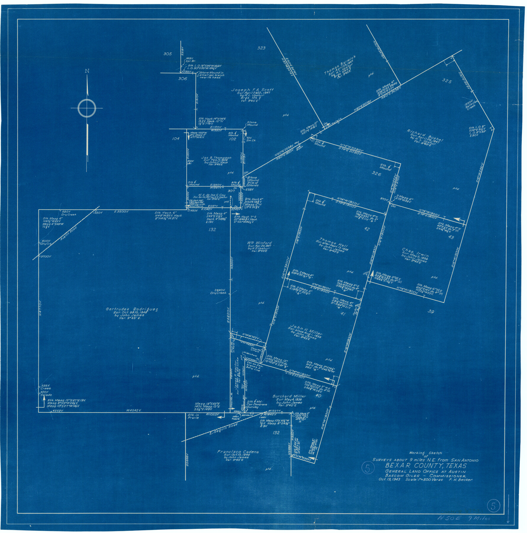
Bexar County Working Sketch 5
-
Map/Doc
67321
-
Collection
General Map Collection
-
Object Dates
10/19/1943 (Creation Date)
-
People and Organizations
Bascom Giles (GLO Commissioner)
F.H. Becker (Draftsman)
-
Counties
Bexar
-
Subjects
Surveying Working Sketch
-
Height x Width
25.3 x 25.0 inches
64.3 x 63.5 cm
-
Scale
1" = 500 varas
-
Comments
Surveys located about nine miles North 50 degrees East of San Antonio, Texas.
Part of: General Map Collection
Flight Mission No. DQN-5K, Frame 24, Calhoun County

Print $20.00
- Digital $50.00
Flight Mission No. DQN-5K, Frame 24, Calhoun County
1953
Size 18.5 x 22.1 inches
Map/Doc 84375
Collingsworth County Working Sketch 6

Print $20.00
- Digital $50.00
Collingsworth County Working Sketch 6
1990
Size 37.7 x 41.8 inches
Map/Doc 68094
Lipscomb County Working Sketch 2

Print $20.00
- Digital $50.00
Lipscomb County Working Sketch 2
1959
Size 33.4 x 36.6 inches
Map/Doc 70578
[Beaumont, Sour Lake and Western Ry. Right of Way and Alignment - Frisco]
![64119, [Beaumont, Sour Lake and Western Ry. Right of Way and Alignment - Frisco], General Map Collection](https://historictexasmaps.com/wmedia_w700/maps/64119.tif.jpg)
Print $20.00
- Digital $50.00
[Beaumont, Sour Lake and Western Ry. Right of Way and Alignment - Frisco]
1910
Size 20.0 x 45.8 inches
Map/Doc 64119
Cameron County Rolled Sketch 25

Print $20.00
- Digital $50.00
Cameron County Rolled Sketch 25
1977
Size 24.8 x 36.6 inches
Map/Doc 5798
Denton County Sketch File 15

Print $8.00
- Digital $50.00
Denton County Sketch File 15
1857
Size 13.1 x 8.2 inches
Map/Doc 20724
Red River County Working Sketch 81-1

Print $20.00
- Digital $50.00
Red River County Working Sketch 81-1
1987
Size 14.6 x 18.4 inches
Map/Doc 72064
Map of Winkler County

Print $20.00
- Digital $50.00
Map of Winkler County
1901
Size 43.1 x 36.6 inches
Map/Doc 4158
Webb County Rolled Sketch 38

Print $20.00
- Digital $50.00
Webb County Rolled Sketch 38
1940
Size 22.2 x 16.0 inches
Map/Doc 8193
Upton County Working Sketch 31

Print $40.00
- Digital $50.00
Upton County Working Sketch 31
1956
Size 33.7 x 49.3 inches
Map/Doc 69527
Flight Mission No. CON-4R, Frame 88, Stonewall County

Print $20.00
- Digital $50.00
Flight Mission No. CON-4R, Frame 88, Stonewall County
1957
Size 18.2 x 22.0 inches
Map/Doc 86992
Walker County Working Sketch 10

Print $20.00
- Digital $50.00
Walker County Working Sketch 10
1935
Size 19.3 x 19.9 inches
Map/Doc 72290
You may also like
Olton Independent School District Lamb County, Texas

Print $20.00
- Digital $50.00
Olton Independent School District Lamb County, Texas
Size 22.3 x 28.5 inches
Map/Doc 92202
Grayson County Working Sketch 8

Print $20.00
- Digital $50.00
Grayson County Working Sketch 8
1944
Size 19.8 x 16.7 inches
Map/Doc 63247

Amistad International Reservoir on Rio Grande 107

Print $20.00
- Digital $50.00
Amistad International Reservoir on Rio Grande 107
1950
Size 28.4 x 40.9 inches
Map/Doc 75538
Map of McCulloch County

Print $20.00
- Digital $50.00
Map of McCulloch County
1874
Size 26.7 x 20.7 inches
Map/Doc 3857
Anderson County Working Sketch 10

Print $20.00
- Digital $50.00
Anderson County Working Sketch 10
1933
Size 31.0 x 48.5 inches
Map/Doc 67009
Revised Map of Calvert, Robertson County, Texas

Print $20.00
- Digital $50.00
Revised Map of Calvert, Robertson County, Texas
Size 25.4 x 19.4 inches
Map/Doc 88741
Leon County Working Sketch 14

Print $40.00
- Digital $50.00
Leon County Working Sketch 14
1956
Size 48.8 x 34.5 inches
Map/Doc 70413
Val Verde County Working Sketch 36

Print $20.00
- Digital $50.00
Val Verde County Working Sketch 36
1942
Size 34.5 x 44.9 inches
Map/Doc 72171
Flight Mission No. BRA-7M, Frame 33, Jefferson County

Print $20.00
- Digital $50.00
Flight Mission No. BRA-7M, Frame 33, Jefferson County
1953
Size 18.6 x 22.4 inches
Map/Doc 85484
Map of Tom Green County

Print $20.00
- Digital $50.00
Map of Tom Green County
1892
Size 44.1 x 47.5 inches
Map/Doc 78389
Pecos County Rolled Sketch 60

Print $20.00
- Digital $50.00
Pecos County Rolled Sketch 60
1926
Size 18.3 x 24.2 inches
Map/Doc 7232