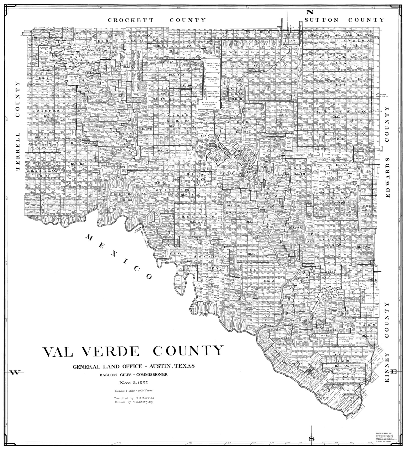
Val Verde County
-
Map/Doc
77445
-
Collection
General Map Collection
-
Object Dates
1944/11/2 (Creation Date)
-
People and Organizations
G.C. Morriss (Compiler)
Victor E. Sterzing (Draftsman)
-
Counties
Val Verde
-
Subjects
County
-
Height x Width
40.0 x 36.2 inches
101.6 x 91.9 cm
Part of: General Map Collection
Lampasas River, City of Lampasas, Lampasas Sheet/Sulphur & Burleson Creeks

Print $20.00
- Digital $50.00
Lampasas River, City of Lampasas, Lampasas Sheet/Sulphur & Burleson Creeks
1937
Size 33.4 x 19.3 inches
Map/Doc 16956
Hutchinson County Working Sketch 47

Print $20.00
- Digital $50.00
Hutchinson County Working Sketch 47
1980
Size 35.2 x 19.9 inches
Map/Doc 66407
Webb County Working Sketch 69

Print $20.00
- Digital $50.00
Webb County Working Sketch 69
1968
Size 38.6 x 37.4 inches
Map/Doc 72436
Brooks County Working Sketch 5

Print $20.00
- Digital $50.00
Brooks County Working Sketch 5
1906
Size 29.8 x 16.3 inches
Map/Doc 67789
Flight Mission No. DCL-7C, Frame 9, Kenedy County

Print $20.00
- Digital $50.00
Flight Mission No. DCL-7C, Frame 9, Kenedy County
1943
Size 15.3 x 15.2 inches
Map/Doc 86001
Sterling County Rolled Sketch 13

Print $20.00
- Digital $50.00
Sterling County Rolled Sketch 13
1945
Size 34.9 x 27.3 inches
Map/Doc 7847
Colorado County Working Sketch 23

Print $20.00
- Digital $50.00
Colorado County Working Sketch 23
1967
Size 38.0 x 32.9 inches
Map/Doc 68123
Baylor County Sketch File 21

Print $40.00
- Digital $50.00
Baylor County Sketch File 21
Size 17.5 x 30.7 inches
Map/Doc 10908
Fisher County Sketch File 21

Print $6.00
- Digital $50.00
Fisher County Sketch File 21
Size 10.3 x 17.0 inches
Map/Doc 22649
Kent County Working Sketch 19

Print $40.00
- Digital $50.00
Kent County Working Sketch 19
1980
Size 36.8 x 51.5 inches
Map/Doc 70026
Red River County Working Sketch 24

Print $20.00
- Digital $50.00
Red River County Working Sketch 24
1958
Size 29.3 x 23.7 inches
Map/Doc 72007
Webb County Working Sketch 55

Print $40.00
- Digital $50.00
Webb County Working Sketch 55
1955
Size 15.9 x 53.2 inches
Map/Doc 72421
You may also like
Guadalupe County Sketch File 5

Print $4.00
- Digital $50.00
Guadalupe County Sketch File 5
1871
Size 8.1 x 10.0 inches
Map/Doc 24659
Rusk County Sketch File Z

Print $6.00
Rusk County Sketch File Z
1850
Size 15.8 x 9.0 inches
Map/Doc 35539
Karnes County Rolled Sketch 1

Print $20.00
- Digital $50.00
Karnes County Rolled Sketch 1
1943
Size 27.5 x 25.7 inches
Map/Doc 6452
Travis County Sketch File 61

Print $8.00
- Digital $50.00
Travis County Sketch File 61
1948
Size 14.4 x 8.8 inches
Map/Doc 38427
[John H. Gibson Block D Showing Patented Sections]
![92450, [John H. Gibson Block D Showing Patented Sections], Twichell Survey Records](https://historictexasmaps.com/wmedia_w700/maps/92450-1.tif.jpg)
Print $20.00
- Digital $50.00
[John H. Gibson Block D Showing Patented Sections]
Size 14.7 x 16.1 inches
Map/Doc 92450
Sherman County Sketch File D

Print $5.00
- Digital $50.00
Sherman County Sketch File D
1959
Size 10.6 x 8.9 inches
Map/Doc 36721
Brown County Working Sketch 20

Print $20.00
- Digital $50.00
Brown County Working Sketch 20
2011
Size 32.8 x 34.8 inches
Map/Doc 89999
Flight Mission No. CRC-2R, Frame 197, Chambers County

Print $20.00
- Digital $50.00
Flight Mission No. CRC-2R, Frame 197, Chambers County
1956
Size 18.7 x 22.5 inches
Map/Doc 84775
Stephens County Working Sketch 12

Print $20.00
- Digital $50.00
Stephens County Working Sketch 12
1947
Size 20.9 x 22.2 inches
Map/Doc 63955
Briscoe County Sketch File 12

Print $4.00
- Digital $50.00
Briscoe County Sketch File 12
1927
Size 11.2 x 8.8 inches
Map/Doc 16426
Flight Mission No. DIX-5P, Frame 151, Aransas County

Print $20.00
- Digital $50.00
Flight Mission No. DIX-5P, Frame 151, Aransas County
1956
Size 17.8 x 18.2 inches
Map/Doc 83813
Randall County

Print $20.00
- Digital $50.00
Randall County
1958
Size 46.2 x 39.9 inches
Map/Doc 95620