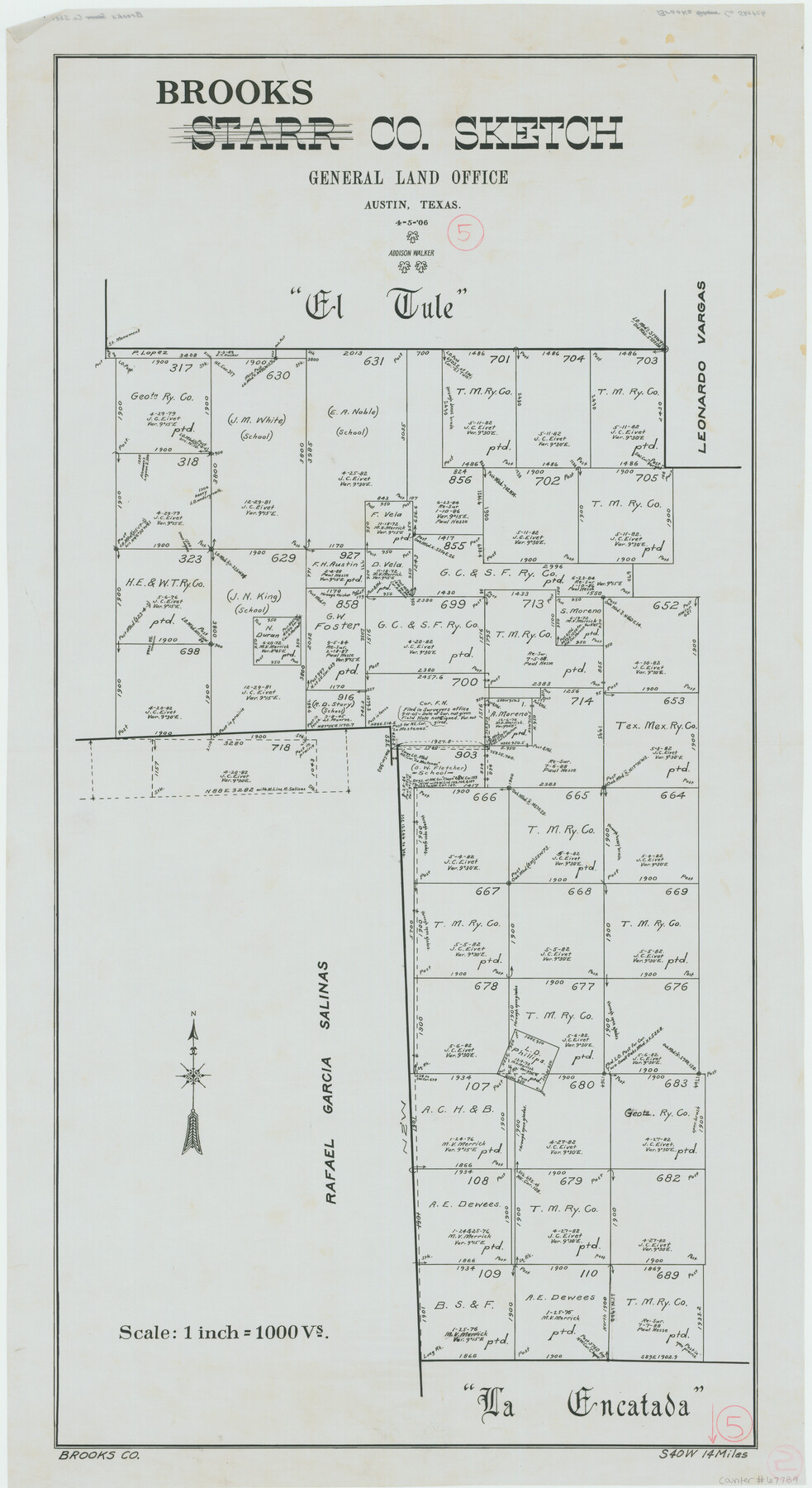
Brooks County Working Sketch 5
-
Map/Doc
67789
-
Collection
General Map Collection
-
Object Dates
4/5/1906 (Creation Date)
-
People and Organizations
Addison Walker (Draftsman)
-
Counties
Brooks
-
Subjects
Surveying Working Sketch
-
Height x Width
29.8 x 16.3 inches
75.7 x 41.4 cm
-
Scale
1" = 1000 varas
Part of: General Map Collection
McCulloch County Working Sketch 7

Print $20.00
- Digital $50.00
McCulloch County Working Sketch 7
1976
Size 35.9 x 30.4 inches
Map/Doc 70682
Flight Mission No. CGI-3N, Frame 143, Cameron County

Print $20.00
- Digital $50.00
Flight Mission No. CGI-3N, Frame 143, Cameron County
1954
Size 18.5 x 22.1 inches
Map/Doc 84616
![94183, Texas [Recto], General Map Collection](https://historictexasmaps.com/wmedia_w700/maps/94183.tif.jpg)
Pecos County Rolled Sketch 18

Print $20.00
- Digital $50.00
Pecos County Rolled Sketch 18
1882
Size 34.4 x 44.1 inches
Map/Doc 9683
Harris County Working Sketch 75

Print $20.00
- Digital $50.00
Harris County Working Sketch 75
1964
Size 29.7 x 32.3 inches
Map/Doc 65967
Mason County Working Sketch 15

Print $40.00
- Digital $50.00
Mason County Working Sketch 15
1976
Size 61.9 x 45.4 inches
Map/Doc 70851
Flight Mission No. DQO-8K, Frame 57, Galveston County

Print $20.00
- Digital $50.00
Flight Mission No. DQO-8K, Frame 57, Galveston County
1952
Size 18.9 x 22.6 inches
Map/Doc 85164

Harris County State Real Property Sketch 4

Print $20.00
- Digital $50.00
Harris County State Real Property Sketch 4
2004
Size 24.4 x 36.0 inches
Map/Doc 82445
Red River County Working Sketch 38

Print $20.00
- Digital $50.00
Red River County Working Sketch 38
1965
Size 24.0 x 24.9 inches
Map/Doc 72021
Lampasas County Sketch File 1

Print $4.00
- Digital $50.00
Lampasas County Sketch File 1
Size 12.6 x 8.1 inches
Map/Doc 29388
Harris County Rolled Sketch 26

Print $20.00
- Digital $50.00
Harris County Rolled Sketch 26
Size 28.2 x 41.3 inches
Map/Doc 6094
You may also like
Reagan County Sketch File 13

Print $40.00
- Digital $50.00
Reagan County Sketch File 13
1931
Size 15.6 x 15.1 inches
Map/Doc 34991
Brazoria County Working Sketch 22

Print $20.00
- Digital $50.00
Brazoria County Working Sketch 22
1959
Size 27.0 x 25.3 inches
Map/Doc 67507
Marion County Working Sketch 26

Print $20.00
- Digital $50.00
Marion County Working Sketch 26
1970
Size 32.3 x 43.1 inches
Map/Doc 70802
South Part Brewster Co.

Print $40.00
- Digital $50.00
South Part Brewster Co.
1915
Size 39.2 x 51.8 inches
Map/Doc 4760
Upton County Working Sketch 10

Print $20.00
- Digital $50.00
Upton County Working Sketch 10
1926
Size 28.1 x 30.6 inches
Map/Doc 69506
Stephens County Sketch File 1B

Print $20.00
- Digital $50.00
Stephens County Sketch File 1B
Size 12.9 x 28.2 inches
Map/Doc 12348
Collin County Working Sketch 1

Print $20.00
- Digital $50.00
Collin County Working Sketch 1
1921
Size 26.6 x 23.4 inches
Map/Doc 68095
King County Rolled Sketch 11

Print $20.00
- Digital $50.00
King County Rolled Sketch 11
1955
Size 40.2 x 46.6 inches
Map/Doc 9351
Map of the Middle States and part of the Southern engraved to illustrate Mitchell's school and family geography

Print $20.00
- Digital $50.00
Map of the Middle States and part of the Southern engraved to illustrate Mitchell's school and family geography
1839
Size 17.8 x 11.8 inches
Map/Doc 93496
Marshall Ford Dam right of way survey, General Ownership Map

Print $40.00
- Digital $50.00
Marshall Ford Dam right of way survey, General Ownership Map
1942
Size 36.6 x 55.9 inches
Map/Doc 60402
Bowie County Working Sketch 2

Print $20.00
- Digital $50.00
Bowie County Working Sketch 2
Size 35.0 x 40.8 inches
Map/Doc 67406
Atlantic Coast to the Rocky Mountains

Atlantic Coast to the Rocky Mountains
1956
Size 42.3 x 29.5 inches
Map/Doc 94410