Atascosa County Rolled Sketch 5A
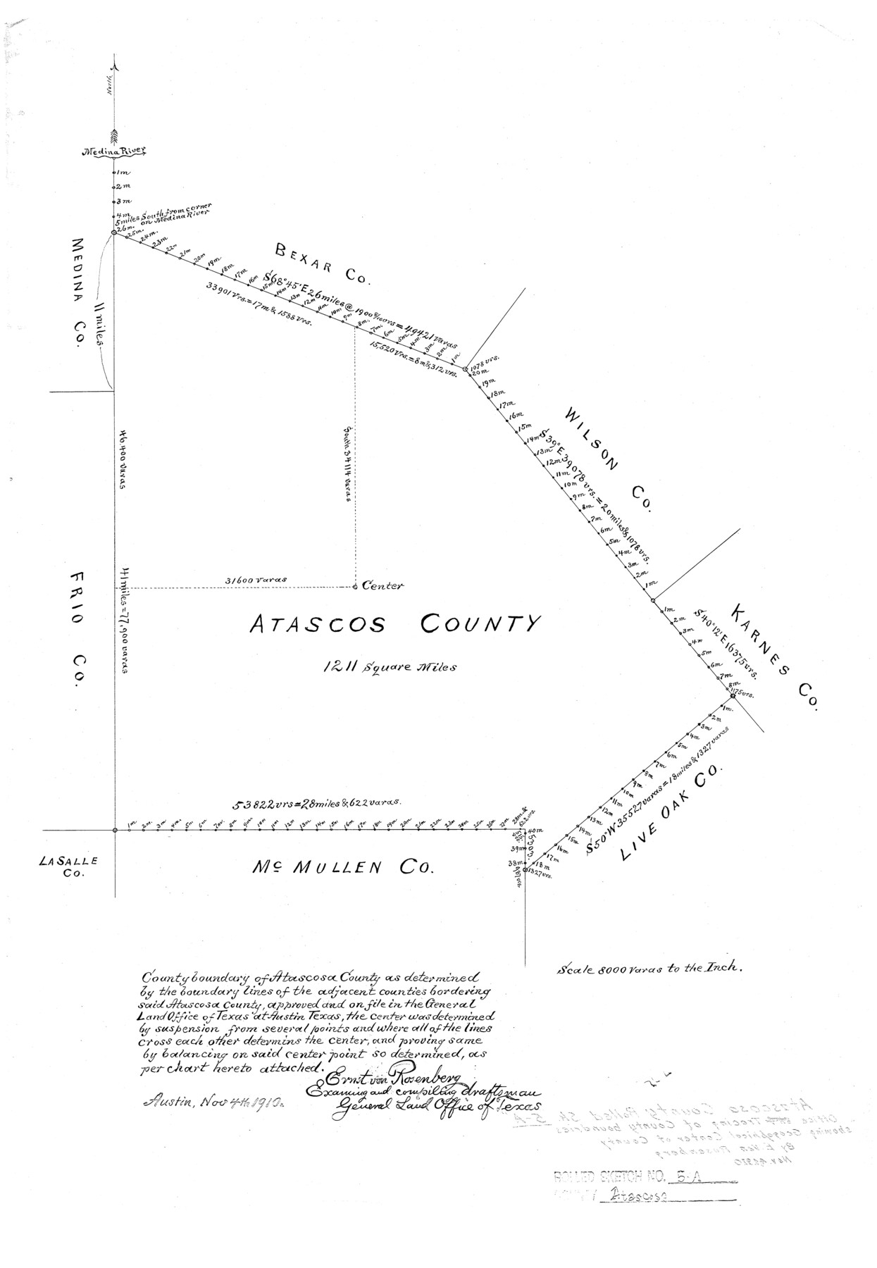
County boundary of Atascosa County as determined by the boundary lines of the adjacent counties bordering said Atascosa County, approved and on file in the General Land Office of Texas at Austin, Texas
-
Map/Doc
5089
-
Collection
General Map Collection
-
Object Dates
1910/11/4 (Creation Date)
-
People and Organizations
Ernst Von Rosenberg (Draftsman)
-
Counties
Atascosa
-
Subjects
County Surveying Rolled Sketch
-
Height x Width
20.8 x 14.4 inches
52.8 x 36.6 cm
-
Medium
linen, manuscript
-
Scale
1" = 8000 varas
-
Comments
Tracing of Atascosa County Rolled Sketch 5 (5088).
Related maps
Atascosa County Rolled Sketch 5

Print $20.00
- Digital $50.00
Atascosa County Rolled Sketch 5
1910
Size 22.1 x 15.8 inches
Map/Doc 5088
Part of: General Map Collection
Midland County Working Sketch 16

Print $40.00
- Digital $50.00
Midland County Working Sketch 16
1953
Size 61.7 x 32.6 inches
Map/Doc 70996
Smith County Sketch File 14

Print $4.00
- Digital $50.00
Smith County Sketch File 14
1888
Size 12.3 x 8.8 inches
Map/Doc 36775
Lynn County Rolled Sketch H

Print $20.00
- Digital $50.00
Lynn County Rolled Sketch H
1902
Size 43.6 x 38.4 inches
Map/Doc 9472
Map of Nolan County

Print $20.00
- Digital $50.00
Map of Nolan County
1902
Size 45.9 x 38.4 inches
Map/Doc 16780
Trinity County Working Sketch 3

Print $20.00
- Digital $50.00
Trinity County Working Sketch 3
1905
Size 26.7 x 19.2 inches
Map/Doc 69451
Tarrant County Working Sketch 6

Print $20.00
- Digital $50.00
Tarrant County Working Sketch 6
1979
Size 29.3 x 18.7 inches
Map/Doc 62423
Culberson County Working Sketch 58

Print $20.00
- Digital $50.00
Culberson County Working Sketch 58
1974
Size 45.2 x 35.1 inches
Map/Doc 68512

Ector County Working Sketch 15

Print $20.00
- Digital $50.00
Ector County Working Sketch 15
1956
Size 44.7 x 39.6 inches
Map/Doc 68858
Randall County

Print $20.00
- Digital $50.00
Randall County
1958
Size 41.0 x 33.0 inches
Map/Doc 77402
Parker County Sketch File 23

Print $20.00
- Digital $50.00
Parker County Sketch File 23
1876
Size 18.8 x 22.8 inches
Map/Doc 12145
Cochran County Sketch File 6

Print $10.00
- Digital $50.00
Cochran County Sketch File 6
1938
Size 11.2 x 8.6 inches
Map/Doc 18545
You may also like
Tahoka Consolidated Independent School District

Print $20.00
- Digital $50.00
Tahoka Consolidated Independent School District
Size 34.1 x 22.1 inches
Map/Doc 92943

Mills County Sketch File 14

Print $4.00
- Digital $50.00
Mills County Sketch File 14
1871
Size 6.8 x 8.0 inches
Map/Doc 31661
Calhoun County Rolled Sketch 30

Print $20.00
- Digital $50.00
Calhoun County Rolled Sketch 30
1974
Size 18.5 x 27.6 inches
Map/Doc 5489
Dimmit County Rolled Sketch 14

Print $40.00
- Digital $50.00
Dimmit County Rolled Sketch 14
1945
Size 56.6 x 36.0 inches
Map/Doc 8797
Crockett County Working Sketch 98

Print $20.00
- Digital $50.00
Crockett County Working Sketch 98
1980
Size 42.8 x 35.9 inches
Map/Doc 68431
Ector County Working Sketch 10

Print $20.00
- Digital $50.00
Ector County Working Sketch 10
1953
Size 25.4 x 39.0 inches
Map/Doc 68853
Primera parte del Mapa, que comprende la Frontera, de los Dominios del Rey, en la America Septentrional

Print $40.00
- Digital $50.00
Primera parte del Mapa, que comprende la Frontera, de los Dominios del Rey, en la America Septentrional
1769
Size 25.8 x 63.2 inches
Map/Doc 3062
Denton County Rolled Sketch 2

Print $40.00
- Digital $50.00
Denton County Rolled Sketch 2
1933
Size 47.1 x 53.5 inches
Map/Doc 8338
Edwards County Working Sketch 138

Print $20.00
- Digital $50.00
Edwards County Working Sketch 138
1999
Size 30.5 x 35.7 inches
Map/Doc 69015
Corpus Christi Harbor

Print $40.00
- Digital $50.00
Corpus Christi Harbor
1976
Size 37.1 x 51.5 inches
Map/Doc 73480
[H. & T. C. Blocks 46 and A along Canadian River]
![91797, [H. & T. C. Blocks 46 and A along Canadian River], Twichell Survey Records](https://historictexasmaps.com/wmedia_w700/maps/91797-1.tif.jpg)
Print $3.00
- Digital $50.00
[H. & T. C. Blocks 46 and A along Canadian River]
Size 13.2 x 9.4 inches
Map/Doc 91797