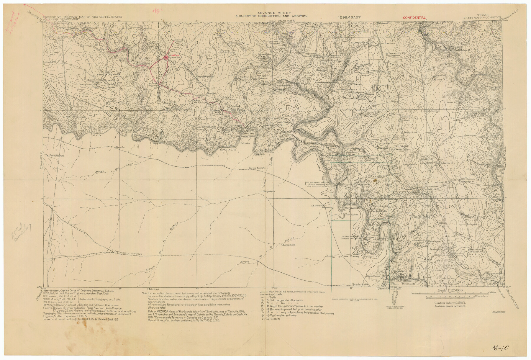
Progressive Military Map of the United States, Southern Department, Sheet 403N, Comstock
M-10
-
Map/Doc
92062
-
Collection
Twichell Survey Records
-
Object Dates
9/1916 (Creation Date)
-
Counties
Terrell Val Verde
-
Subjects
Military Topographic
-
Height x Width
35.0 x 23.9 inches
88.9 x 60.7 cm
Part of: Twichell Survey Records
[Sketch showing surveys in the south half of Potter County, Blocks 6, 20-E, JAD, M-3, S, B. S. & F. Blocks 1 and 9, and A. B. and M. Block 2]
![91741, [Sketch showing surveys in the south half of Potter County, Blocks 6, 20-E, JAD, M-3, S, B. S. & F. Blocks 1 and 9, and A. B. and M. Block 2], Twichell Survey Records](https://historictexasmaps.com/wmedia_w700/maps/91741-1.tif.jpg)
Print $20.00
- Digital $50.00
[Sketch showing surveys in the south half of Potter County, Blocks 6, 20-E, JAD, M-3, S, B. S. & F. Blocks 1 and 9, and A. B. and M. Block 2]
Size 40.5 x 18.1 inches
Map/Doc 91741
[Block 1, B. S. & F.]
![90492, [Block 1, B. S. & F.], Twichell Survey Records](https://historictexasmaps.com/wmedia_w700/maps/90492-1.tif.jpg)
Print $2.00
- Digital $50.00
[Block 1, B. S. & F.]
1904
Size 8.3 x 10.5 inches
Map/Doc 90492
[H. & G. N. Block 1, G. C. & S. F. Block Z]
![91168, [H. & G. N. Block 1, G. C. & S. F. Block Z], Twichell Survey Records](https://historictexasmaps.com/wmedia_w700/maps/91168-1.tif.jpg)
Print $3.00
- Digital $50.00
[H. & G. N. Block 1, G. C. & S. F. Block Z]
Size 16.8 x 10.5 inches
Map/Doc 91168
Map of Young County

Print $20.00
- Digital $50.00
Map of Young County
Size 25.6 x 29.8 inches
Map/Doc 92023
Selected List of Wells accompanying Map of Wyoming showing Test Wells for Oil and Gas, Anticlinal Axes, Oil and Gas Fields, Pipelines, Unit Areas, and Land 3 District Boundaries, 1949

Print $20.00
- Digital $50.00
Selected List of Wells accompanying Map of Wyoming showing Test Wells for Oil and Gas, Anticlinal Axes, Oil and Gas Fields, Pipelines, Unit Areas, and Land 3 District Boundaries, 1949
1949
Size 26.2 x 41.5 inches
Map/Doc 89690
Sketch in Parmer County

Print $20.00
- Digital $50.00
Sketch in Parmer County
1901
Size 15.1 x 23.8 inches
Map/Doc 91644
Carden L. Green Farm Part Sections 13 & 22, Block JS

Print $20.00
- Digital $50.00
Carden L. Green Farm Part Sections 13 & 22, Block JS
Size 14.0 x 24.1 inches
Map/Doc 92324

[I. & G. N. Block 1]
![91592, [I. & G. N. Block 1], Twichell Survey Records](https://historictexasmaps.com/wmedia_w700/maps/91592-1.tif.jpg)
Print $20.00
- Digital $50.00
[I. & G. N. Block 1]
Size 17.2 x 18.1 inches
Map/Doc 91592

Official Map, City of Lubbock, Lubbock County, Texas

Print $20.00
- Digital $50.00
Official Map, City of Lubbock, Lubbock County, Texas
1927
Size 24.1 x 32.9 inches
Map/Doc 91329
Roach Estate Ranch, Gaines County, Texas

Print $20.00
- Digital $50.00
Roach Estate Ranch, Gaines County, Texas
Size 18.0 x 34.6 inches
Map/Doc 92681
You may also like
Cottle County Working Sketch 2

Print $3.00
- Digital $50.00
Cottle County Working Sketch 2
1902
Size 9.9 x 13.2 inches
Map/Doc 68312
Menard County Boundary File 10

Print $4.00
- Digital $50.00
Menard County Boundary File 10
Size 14.2 x 8.7 inches
Map/Doc 57096
Trinity County Sketch File 26

Print $8.00
- Digital $50.00
Trinity County Sketch File 26
1885
Size 13.1 x 8.4 inches
Map/Doc 38558
Midland County Working Sketch 16

Print $40.00
- Digital $50.00
Midland County Working Sketch 16
1953
Size 61.7 x 32.6 inches
Map/Doc 70996
![3295, [Bell County], General Map Collection](https://historictexasmaps.com/wmedia_w700/maps/3295-1.tif.jpg)
Calhoun County Sketch File 10

Print $11.00
- Digital $50.00
Calhoun County Sketch File 10
1956
Size 14.3 x 8.8 inches
Map/Doc 35940
Flight Mission No. BRA-16M, Frame 131, Jefferson County

Print $20.00
- Digital $50.00
Flight Mission No. BRA-16M, Frame 131, Jefferson County
1953
Size 18.4 x 22.5 inches
Map/Doc 85741
Mills County Boundary File 1

Print $28.00
- Digital $50.00
Mills County Boundary File 1
Size 8.3 x 8.0 inches
Map/Doc 57259
Township No. 7 South Range No. 4 West of the Indian Meridian, Chickasaw Lands

Print $4.00
- Digital $50.00
Township No. 7 South Range No. 4 West of the Indian Meridian, Chickasaw Lands
1871
Size 18.2 x 22.4 inches
Map/Doc 75146
A Traveler's Map of Spain and Portugal

A Traveler's Map of Spain and Portugal
Size 20.4 x 31.2 inches
Map/Doc 95929
San Jacinto County Working Sketch 20

Print $20.00
- Digital $50.00
San Jacinto County Working Sketch 20
1939
Size 30.3 x 24.0 inches
Map/Doc 63733
Hamilton County Boundary File 2

Print $4.00
- Digital $50.00
Hamilton County Boundary File 2
Size 14.2 x 8.8 inches
Map/Doc 54195